HIGH MOUNTAIN DRYFORK WV 26263, Davis, WV 26263 - Randolph County
7.27 Acres for Sale in Randolph County West Virginia for $399 a month!!
7.27 Acres for Sale in Randolph County West Virginia for $399 a month!!
Owner Financing May Be Available!
Contact us Today!!
If you are interested in purchasing this property, call, text or E-mail us now to sign the contract, and send the deposit! (540) 824-3372
Owner financing may be available upon transfer of title.
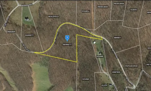
Feel free to visit the property any time, no need to set up an appointment, this property has no address.
Special ad notes:This property has covenants and restrictions. And is in an HOA. Contact for the HOA is as follows:
John Jelinski Secretary, High Mountain Owners Association
703- 609- 7001
All the lots pay the same fee since the fee for HOA, it is primarily used for road maintenance. The single fee arrangement is locked in the covenants and can't be changed. The annual assessment for 2021 was $700.This was the first increase in about 5 years.
Address: HIGH MOUNTAIN DRYFORK WV 26263
Cash Discount Price: $9,900.00
Financed Price (includes all interest, property taxes and loan servicing fees): $33,728.00
Owner Financing Terms: $5,000 down and $399 per month for 72 months
County: Randolph
Acres: 7.27 Acres (Raw Land)
Coordinates: 38.91339, -79.48579
Parcel #: 04-146-00790000
Tax account #: 00128904
Yearly Taxes: $202.06
Legal Description: All of that certain tract of real estate situate in Dry Fork District, Randolph County, west Virginia, described by survey prepared by Valley Surveying, Licensed Land Surveyors, dated JuneAugust, 1989, as follows:
Lot No. 8 of the High Mountain Development, containing 7.27 acres, more or less, and shown on that certain plat of survey for High Mountain Corporation which is recorded in the Office of the Clerk of the County Commission of Randolph County, West Virginia, in Plat Cabinet No. C, at Slid 19, and to which reference is made for a more particular description of said lot. Included therein are the roadways and rights of way and metes and bounds description of the lot herein conveyed and reference is made to said plat for all pertinent purposes. There is further granted to the said Grantees, their successors and assigns, the right of ingress, egress and regress from West Virginia State Route 33 to the aforesaid lot on and over the roadways shown on the aforesaid plat, and as well on and over the roadway shown and described on that certain plat of existing and proposed roads for High Mountain Corporation, which said plat of record in the aforesaid Clerks Office in Plat Cabinet C, at Slide No. 19. Said right of ingress, egress and egress shall be non-exclusive in nature and shall be in common with other owners of lots in High Mountain Development. This conveyance is subject to the Declaration of Protective Covenants and Restrictions for Tracts 1-24 and 26-36 of the High Mountain Development, dated the 10th day of October, 1989, and recorded in the aforesaid Clerks Office in Deed Book 400, at page 566. Said covenants and restrictions are considered as covenants to run with the land herein conveyed and the same are incorporated herein by reference and to have the same force and effect as though textually incorporated as being within the body of this deed. There was specifically reserved to High Mountain Corporation, its successors and assigns, in previous instruments of record, easements upon, over, through, along, or under each tract, together with the right of ingress and egress to the extent reasonably necessary to exercise such easements, as are more particularly described in the Declaration of Protective Covenants and Restrictions aforesaid. This conveyance is expressly made subject to all prior reservations, restrictions, exceptions, easements, right of way, covenants, conditions and limitations that may be found in instruments of record in the chain of title and said real estate. APN#: 04-146-0079-0000-0000
Elevation: 3299 ft.
County Planning and zoning phone #: (304) 636-2114
Elementary school: HARMAN ELEMENTARY/HIGH SCHOOL
Middle school: HARMAN ELEMENTARY/HIGH SCHOOL
High school: HARMAN ELEMENTARY/HIGH SCHOOL
If this property is not what you are looking for, go to our website and sign up for our deal alerts; you will be notified whenever we have a new property for sale! Or, e-mail, call or text us, and we may be able to find the property you are looking for.
From elevation to risk assessment
Search for detailed parcel information including; Elevation & Vegetation Maps, Ownership Information, Detailed Parcel Information, Crop History Map, Soil Survey Productivity Data, and more.
Research Parcel InformationDirections
Davis
West Virginia 26260
Head east on WV-32 S/William Ave toward 3rd St
Continue to follow WV-32 S
18.7 mi
Turn left onto WV-32
0.1 mi
Slight left onto US-33 E
2.3 mi
Turn left
0.2 mi
Slight right onto High Mountain Rd
0.7 mi
Turn left onto High Mountain
Destination will be on the left
0.4 mi
Resources
Land for Sale by Luke Harris
Randolph County Properties By Type
- Farms for Sale in Randolph County, West Virginia
- Undeveloped Land for Sale in Randolph County, West Virginia
- Hunting Land for Sale in Randolph County, West Virginia
- Riverfront Property for Sale in Randolph County, West Virginia
- Recreational Property for Sale in Randolph County, West Virginia
- Residential Property for Sale in Randolph County, West Virginia
- Commercial Property for Sale in Randolph County, West Virginia
- Timberland for Sale in Randolph County, West Virginia
- Lakefront Property for Sale in Randolph County, West Virginia
- Ranches for Sale in Randolph County, West Virginia
- Horse Property for Sale in Randolph County, West Virginia
- Beachfront Property for Sale in Randolph County, West Virginia
Properties for Sale Nearby Counties
- Barbour County, West Virginia Land for Sale
- Grant County, West Virginia Land for Sale
- Pendleton County, West Virginia Land for Sale
- Pocahontas County, West Virginia Land for Sale
- Tucker County, West Virginia Land for Sale
- Upshur County, West Virginia Land for Sale
- Webster County, West Virginia Land for Sale
Randolph County Properties By City
- Beverly, West Virginia Land for Sale
- Bowden, West Virginia Land for Sale
- Coalton, West Virginia Land for Sale
- Dailey, West Virginia Land for Sale
- Dryfork, West Virginia Land for Sale
- Elkins, West Virginia Land for Sale
- Ellamore, West Virginia Land for Sale
- Glady, West Virginia Land for Sale
- Harman, West Virginia Land for Sale
- Helvetia, West Virginia Land for Sale
- Huttonsville, West Virginia Land for Sale
- Kerens, West Virginia Land for Sale
- More
- Mabie, West Virginia Land for Sale
- Mill Creek, West Virginia Land for Sale
- Monterville, West Virginia Land for Sale
- Montrose, West Virginia Land for Sale
- Norton, West Virginia Land for Sale
- Pickens, West Virginia Land for Sale
- Valley Bend, West Virginia Land for Sale
- Valley Head, West Virginia Land for Sale
- Whitmer, West Virginia Land for Sale
- Job, West Virginia Land for Sale
- Mingo, West Virginia Land for Sale
- Wymer, West Virginia Land for Sale
- Adolph, West Virginia Land for Sale
- Aggregates, West Virginia Land for Sale
- Alpena, West Virginia Land for Sale
- Arnold Hill, West Virginia Land for Sale
- Arvondale, West Virginia Land for Sale
- Bemis, West Virginia Land for Sale
- Beulah, West Virginia Land for Sale
- Blue Rock, West Virginia Land for Sale
- Blue Spring, West Virginia Land for Sale
- Brady Gate, West Virginia Land for Sale
- Brush Camp Low Place, West Virginia Land for Sale
- Bruxton, West Virginia Land for Sale
- Canaan Crossing, West Virginia Land for Sale
- Cassity, West Virginia Land for Sale
- Cheat Junction, West Virginia Land for Sale
- Crystal Springs, West Virginia Land for Sale
- Cubana, West Virginia Land for Sale
- Czar, West Virginia Land for Sale
- East Dailey, West Virginia Land for Sale
- Elk River Junction, West Virginia Land for Sale
- Elkins Junction, West Virginia Land for Sale
- Elkwater, West Virginia Land for Sale
- Evenwood, West Virginia Land for Sale
- Faulkner, West Virginia Land for Sale
- Flint, West Virginia Land for Sale
- Gandy, West Virginia Land for Sale
- Gilman, West Virginia Land for Sale
- Glenmore, West Virginia Land for Sale
- Greenbrier Junction, West Virginia Land for Sale
- Harding, West Virginia Land for Sale
- Harperton, West Virginia Land for Sale
- Harpertown, West Virginia Land for Sale
- Hazelwood, West Virginia Land for Sale
- Highland Park, West Virginia Land for Sale
- Horton, West Virginia Land for Sale
- Kingsville, West Virginia Land for Sale
- Leadsville, West Virginia Land for Sale
- Lee Bell, West Virginia Land for Sale
- Loda, West Virginia Land for Sale
- Meadows, West Virginia Land for Sale
- Middlebrook, West Virginia Land for Sale
- Midland, West Virginia Land for Sale
- Osceola, West Virginia Land for Sale
- Pumpkintown, West Virginia Land for Sale
- Read, West Virginia Land for Sale
- Roaring Creek Junction, West Virginia Land for Sale
- Silica, West Virginia Land for Sale
- Smith Crossing, West Virginia Land for Sale
- Spangler, West Virginia Land for Sale
- Sullivan, West Virginia Land for Sale
- Sully, West Virginia Land for Sale
- Upper Mingo, West Virginia Land for Sale
- Weese, West Virginia Land for Sale
- Whyte, West Virginia Land for Sale