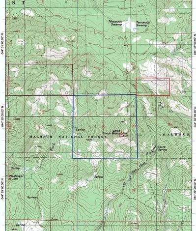
720 acres in Grant County, Oregon
Little Black Butte
Size: This property is composed of 720 acres which is in effect 2 parcels that kitty corner each other.
Location: From Mt. Vernon, Or. You will go 14 miles northwest and from Long Creek, Or. You will go 14 miles southwest to the property. It is on the south side of Fox Valley.
Elevation: 4600’-5400’
Access: Access will be through Fox Valley and the USFS roads that lead through to it. It will be limited in the winter time and available usually only with snowmobiles for that time of year.
Timber: Fir and Pine forests inhabit these parcels and constitutes about 1 Million Board Feet. It is pretty well north slope forest in some of these areas.
Water: Water is plentiful with springs and Fall Creek. Fall Creek runs for about a quarter mile in the property.
Wildlife: Elk, deer, turkeys all abound in this West Northside Unit. You will be able to receive your LOPs for it by applying to the Oregon Department of Fish and Wildlife. The Northside draw is sometimes difficult to get so it is a coveted tag. There is a 3 season 8 month cow tag for this area. That really shows the number of elk here. There is also coyote, bobcat, cougar, grouse, and birds of prey.
General Thoughts: This property has USFS on three sides of it. It has saddles, buttes, deep draws, and some open hillsides. It is a bowhunter’s dream. It is not fenced. Primary Forest is the zoning and is buildable according to the land use laws of Grant County.
Price: $689,000
All information is deemed reliable and correct from the owners and representatives. No guarantees are made or implied. A prospective purchaser is expected to carefully investigate and verify the above information as well as all matters affecting the property.
Wilburn Ranch Brokerage
From elevation to risk assessment
Search for detailed parcel information including; Elevation & Vegetation Maps, Ownership Information, Detailed Parcel Information, Crop History Map, Soil Survey Productivity Data, and more.
Research Parcel InformationLand for Sale by Andy Wilburn
Grant County Properties By Type
- Ranches for Sale in Grant County, Oregon
- Undeveloped Land for Sale in Grant County, Oregon
- Residential Property for Sale in Grant County, Oregon
- Farms for Sale in Grant County, Oregon
- Hunting Land for Sale in Grant County, Oregon
- Lakefront Property for Sale in Grant County, Oregon
- Riverfront Property for Sale in Grant County, Oregon
- Commercial Property for Sale in Grant County, Oregon
- Recreational Property for Sale in Grant County, Oregon
- Timberland for Sale in Grant County, Oregon
- Horse Property for Sale in Grant County, Oregon
- Beachfront Property for Sale in Grant County, Oregon
Properties for Sale Nearby Counties
Grant County Properties By City
- Bates, Oregon Land for Sale
- Canyon City, Oregon Land for Sale
- Dayville, Oregon Land for Sale
- John Day, Oregon Land for Sale
- Kimberly, Oregon Land for Sale
- Long Creek, Oregon Land for Sale
- Monument, Oregon Land for Sale
- Mount Vernon, Oregon Land for Sale
- Prairie City, Oregon Land for Sale
- Seneca, Oregon Land for Sale
- Fox, Oregon Land for Sale
- Ritter, Oregon Land for Sale
- More
- Austin, Oregon Land for Sale
- Beech Creek, Oregon Land for Sale
- Cabell City, Oregon Land for Sale
- Courtrock, Oregon Land for Sale
- Galena, Oregon Land for Sale
- Hamilton, Oregon Land for Sale
- Izee, Oregon Land for Sale
- Range, Oregon Land for Sale
- Robinsonville, Oregon Land for Sale
- Silvies, Oregon Land for Sale
- Susanville, Oregon Land for Sale
- Three Forks, Oregon Land for Sale