1187 Limestone, Redfield, KS 66769 - Bourbon County
Auction Information
750 acres in Bourbon County, Kansas
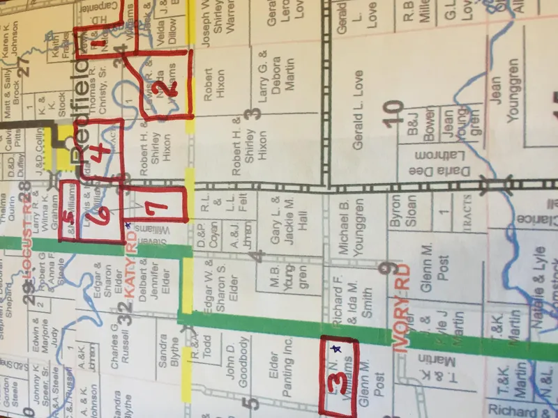
7 Tracts of Land: Tillable, Improved, Pasture, Hay, CRP. All tracts & homestead with Morton building in Redfield, Kansas area.
Tract 1: All that part N 1/2 of SE 1/4 lying N of Marmaton River and W 1/2 of NW 1/4 of Section 34, Township 25, Range 23 containing 130 acres, M/L. Est. 2015 Taxes $805.91
Tract 2: Tract in S/W 1/4, Section 34, Township 25, Range 23, containing 130 acres, M/L. Est. 2015 Taxes $805.91
Tract 3: The North Half of the NE Quarter of Section Eight (8), Township Twenty-six (26), Range Twenty-Three (23), less R/W, containing 80 acres, M/L Est. 2015 taxes $717.62
Tract 4: Tract in E 1/2 NE 1/4 of SW 1/4 NE 1/4 less N. 150' of W 425' NE 1/4 NE 1/4, less RW, Less R/W, in Section 33, Township 25, Range 23, containing 124 acres, M/L. Est. 2015 Taxes $717.62
Tract 5: Tract in SW Cor SE 1/4 of, Section 28, Township 25, Range 23, containing 40 acres, M/L, with homestead & Morton bldg., Commonly known as 1187 Limestone Road. Est. 2015 taxes $1354.84
Tract 6: NW 1/4 Section 33, Township 25, Range 23, less R/W, containing 160 acres, M/L. Est. 2015 taxes $560.66
Tract 7: Tract in the E 1/2 SW 1/4, Section 33, Township 25, Range 23, containing 80 acres, M/L. Est. 2015 Taxes $495.66
From elevation to risk assessment
Search for detailed parcel information including; Elevation & Vegetation Maps, Ownership Information, Detailed Parcel Information, Crop History Map, Soil Survey Productivity Data, and more.
Research Parcel InformationBourbon County Properties By Type
- Farms for Sale in Bourbon County, Kansas
- Hunting Land for Sale in Bourbon County, Kansas
- Lakefront Property for Sale in Bourbon County, Kansas
- Ranches for Sale in Bourbon County, Kansas
- Commercial Property for Sale in Bourbon County, Kansas
- Riverfront Property for Sale in Bourbon County, Kansas
- Undeveloped Land for Sale in Bourbon County, Kansas
- Residential Property for Sale in Bourbon County, Kansas
- Recreational Property for Sale in Bourbon County, Kansas
- Timberland for Sale in Bourbon County, Kansas
- Horse Property for Sale in Bourbon County, Kansas
- Beachfront Property for Sale in Bourbon County, Kansas
Properties for Sale Nearby Counties
Bourbon County Properties By City
- Bronson, Kansas Land for Sale
- Fort Scott, Kansas Land for Sale
- Fulton, Kansas Land for Sale
- Garland, Kansas Land for Sale
- Mapleton, Kansas Land for Sale
- Redfield, Kansas Land for Sale
- Uniontown, Kansas Land for Sale
- Barnesville, Kansas Land for Sale
- Devon, Kansas Land for Sale
- Harding, Kansas Land for Sale
- Hiattville, Kansas Land for Sale
- Porterville, Kansas Land for Sale
- More