Auction Information
Duane & Marlys Darnell Farm Auction
Description
750.54± acres of farmland located along Highway 169 in Faribault County, MN
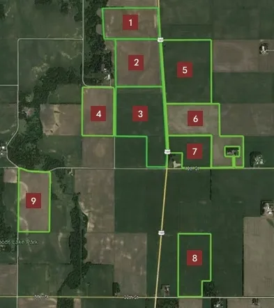
The Duane & Marlys Darnell farm is 9 parcels totaling 750 acres of prime farmland. These tracts offer an excellent opportunity for farmers or investors seeking quality farmland in a highly productive area. The soils are primarily Waldorf silty clay loam, Brownton silty clay loam, and Okoboji silty clay loam. NRCS classifications include NHEL and PC/NW. All parcels are open to farm or lease for the 2026 crop year.
Parcel 1: 69.91± total acres with 67.30± of FSA tillable acres (89.4 CPI) This rolling tract has an outlet to the river on the west side.
Parcel 2: 82.81± total acres with 82.75± of FSA tillable acres (92.0 CPI) This level to gently rolling tract has private mains and laterals with an outlet to a county ditch and river.
Parcel 3: 117.43± total acres with 114.89± of FSA tillable acres (84.3 CPI) This level to gently rolling tract has private mains and laterals with an outlet to the county ditch.
Parcel 4: 61.59± total acres with 58.78± of FSA tillable acres (90.0 CPI) This level tract has private mains and laterals with an outlet to the county ditch.
Parcel 5: 117.94± total acres with 117.08± of FSA tillable acres (87.9 CPI) This level tract has private mains and laterals with an outlet to a county ditch.
Parcel 6: 103.83± total acres with 97.82± of FSA tillable acres (85.0 CPI) This level tract has an outlet to the county ditch.
Parcel 7: 45± total acres with 44.54± of FSA tillable acres (85.2 CPI) This level tract has private mains and lateral with an outlet to the county ditch.
Parcel 8: 74.53± total acres with 72.62± of FSA tillable acres (87.4 CPI) This level tract has private mains and laterals with outlet to a county ditch.
Parcel 9: 77.50± total acres with 72.09± of FSA tillable acres (83.9 CPI) This gently rolling tract has private mains and laterals with an outlet to a county ditch.
From elevation to risk assessment
Search for detailed parcel information including; Elevation & Vegetation Maps, Ownership Information, Detailed Parcel Information, Crop History Map, Soil Survey Productivity Data, and more.
Research Parcel InformationDirections
Environmental Factors
Resources
Faribault County Properties By Type
- Lakefront Property for Sale in Faribault County, Minnesota
- Farms for Sale in Faribault County, Minnesota
- Hunting Land for Sale in Faribault County, Minnesota
- Commercial Property for Sale in Faribault County, Minnesota
- Undeveloped Land for Sale in Faribault County, Minnesota
- Riverfront Property for Sale in Faribault County, Minnesota
- Residential Property for Sale in Faribault County, Minnesota
- Recreational Property for Sale in Faribault County, Minnesota
- Ranches for Sale in Faribault County, Minnesota
- Timberland for Sale in Faribault County, Minnesota
- Horse Property for Sale in Faribault County, Minnesota
- Beachfront Property for Sale in Faribault County, Minnesota
Properties for Sale Nearby Counties
Faribault County Properties By City
- Blue Earth, Minnesota Land for Sale
- Bricelyn, Minnesota Land for Sale
- Delavan, Minnesota Land for Sale
- Easton, Minnesota Land for Sale
- Elmore, Minnesota Land for Sale
- Frost, Minnesota Land for Sale
- Huntley, Minnesota Land for Sale
- Kiester, Minnesota Land for Sale
- Minnesota Lake, Minnesota Land for Sale
- Wells, Minnesota Land for Sale
- Winnebago, Minnesota Land for Sale
- Walters, Minnesota Land for Sale
- More