PEZZANITE FOREST
Description
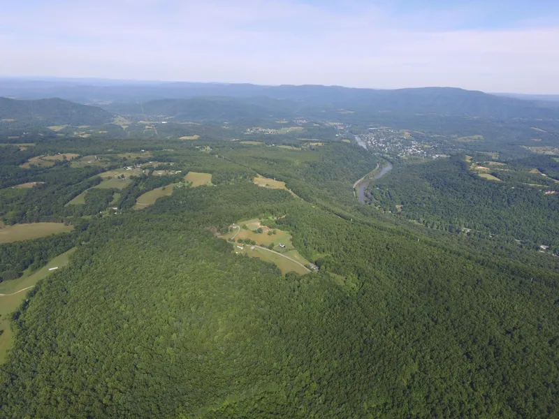
The 753 acre PEZZANITE FOREST (Pie-Zan-I-Tee) is an top-flight recreational property with tremendous wildlife, valuable timber and 5 miles of improved interior roads and forest trails.This exceptional property located just 10 minutes to the Greenbrier River and 30 minutes to the New River Gorge.
Enjoy the partial description below, and be sure to catch the photos and maps. Many more details are available on the Foxfire Realty website. To go directly to the property listing, just click the Website link!
HIGHLIGHTS
753 acre forested mountain range
All mineral rights in title will convey
10 minutes to the Greenbrier River
Well managed forest by professional foresters for over 40 years
Valuable timber is harvest ready for immediate income
5 miles of improved interior roads (graveled, ditched with culverts) wind through the property on gentle grades suitable for future residential development. Additionally, many more miles of forest trails provide superior access to nearly every part of the property
Professionally managed wildlife program developed to enhance the habitat, increase species diversity, promote the health of the resident wildlife and increase the carrying capacity.
Interesting moss-covered rock outcrops and rock cliffs
Permaculture lifestyle could be developed
Surrounded by large timber tracts and mountain farms in a nice rural neighborhood
Darkest of skies with little or no light pollution for star and planet gazing
Native sedges, rushes, ferns, songbirds, frogs, turtles, crawdads all enjoy the creeks
Located in peaceful Monroe County near Union, the county seat
Several ancient Heritage trees scattered about the forest estimated at 200-300 years old
Timber species include, oaks, walnut, poplar, maple, white pine, hemlock and hickories
Electricity is onsite
Winged wildlife includes eagles, hawks, owls, ravens, and Neotropical songbirds
Diverse topography containing a mature forest, emerging forest, old fields, huge rock outcrops and ancient trees create a fascinating natural setting
Forest is a tremendous producer of life-giving Oxygen and a major sequester of carbon
Several dash-blueline streams flowing through the property
State maintained road frontage for superior access
Spectacular long-range views approaching 20 miles
High percentage of commercially operable ground supporting forestry, recreation and potential for numerous future cabin sites
Perfect for shooting sports, ATV riding, horseback riding, hiking, camping, hunting and nature viewing.
Low taxes, low population density
LOCATION
Google Coordinates: 37.701695(N), -80.597694(W)
Address: Laurel Creek Rd RT 2, Alderson, WV 24910; No 911 address is assigned to property without structures.
Elevation Range: 2307 ft. to 2740 ft. +/-
WATER
There are 2 dashed blue-line or intermittent streams that run long distances within the forest before merging into one stream and leaving the forest. Those intermittent streams are the beginning headwaters of Laurel Creek, and should flow during rain events and snow melt. Downstream, Laurel Creek becomes larger and supports Wolf Creek.
BOUNDARIES AND SURVEY
Over the years, the property lines have been surveyed and painted. The property is being sold by the boundary and not by the acre.
PROPERTY TYPE/USE SUMMARY
This property has been devoted to managed forestland for many years.
PUBLIC SCHOOLS
Monroe County and Greenbrier County School Districts
Public Elementary Schools:
Mountain View Elementary School, Union, Monroe County
Alderson Elementary School, Alderson, Greenbrier County
Public Middle Schools:
Mountain View Middle School, Union, Monroe County
Eastern Greenbrier Middle School, Fairlea, Greenbrier County
Public High Schools:
James Monroe High School, Union, Monroe County
Greenbrier East High School, Fairlea, Greenbrier County
From elevation to risk assessment
Search for detailed parcel information including; Elevation & Vegetation Maps, Ownership Information, Detailed Parcel Information, Crop History Map, Soil Survey Productivity Data, and more.
Research Parcel InformationDirections
To follow-up with your interest, call the Foxfire Office 304.645.7674.
From Alderson, West Virginia: 4 miles +/- (approximately 10 minutes)From the Greenbrier County side of Alderson, cross the RT 3 South bridge over the Greenbrier River; continue left with RT 3 South; after going through the sharp turn to the right in town, travel a short distance and turn left onto Flat Mountain Road RT 1; travel 1.9 miles; turn left onto Laurel Creek / Sunset School Road RT 2/1; travel RT 2/1 for 1.7 miles; the property entrance road is on the left.
Environmental Factors
Resources
Monroe County Properties By Type
- Farms for Sale in Monroe County, West Virginia
- Residential Property for Sale in Monroe County, West Virginia
- Hunting Land for Sale in Monroe County, West Virginia
- Undeveloped Land for Sale in Monroe County, West Virginia
- Riverfront Property for Sale in Monroe County, West Virginia
- Commercial Property for Sale in Monroe County, West Virginia
- Lakefront Property for Sale in Monroe County, West Virginia
- Recreational Property for Sale in Monroe County, West Virginia
- Timberland for Sale in Monroe County, West Virginia
- Ranches for Sale in Monroe County, West Virginia
- Horse Property for Sale in Monroe County, West Virginia
- Beachfront Property for Sale in Monroe County, West Virginia
Properties for Sale Nearby Counties
Monroe County Properties By City
- Ballard, West Virginia Land for Sale
- Gap Mills, West Virginia Land for Sale
- Greenville, West Virginia Land for Sale
- Lindside, West Virginia Land for Sale
- Peterstown, West Virginia Land for Sale
- Secondcreek, West Virginia Land for Sale
- Sinks Grove, West Virginia Land for Sale
- Union, West Virginia Land for Sale
- Waiteville, West Virginia Land for Sale
- Wayside, West Virginia Land for Sale
- Wolfcreek, West Virginia Land for Sale
- Bozoo, West Virginia Land for Sale
- More
- Glace, West Virginia Land for Sale
- Pickaway, West Virginia Land for Sale
- Sarton, West Virginia Land for Sale
- Sweet Springs, West Virginia Land for Sale
- Assurance, West Virginia Land for Sale
- Cashmere, West Virginia Land for Sale
- Centennial, West Virginia Land for Sale
- Creamery, West Virginia Land for Sale
- Crimson Springs, West Virginia Land for Sale
- Dorr, West Virginia Land for Sale
- Elmhurst, West Virginia Land for Sale
- Gates, West Virginia Land for Sale
- Hollywood, West Virginia Land for Sale
- Johnson Crossroads, West Virginia Land for Sale
- Keenan, West Virginia Land for Sale
- Knobs, West Virginia Land for Sale
- Laurel Branch, West Virginia Land for Sale
- McGlone, West Virginia Land for Sale
- Monitor, West Virginia Land for Sale
- Nickells Mill, West Virginia Land for Sale
- Pedro, West Virginia Land for Sale
- Raines Corner, West Virginia Land for Sale
- Rock Camp, West Virginia Land for Sale
- Roxalia, West Virginia Land for Sale
- Salt Sulphur Springs, West Virginia Land for Sale
- Wikel, West Virginia Land for Sale
- Zenith, West Virginia Land for Sale