Rural land near Hoover, AL
Description
Located south of I-459 near McCalla & the Bessemer Airport, about 12 minutes to I-459 Exit 1 or Exit 6
Property available as a 78-acre tract, a 17-acre tract (north of the road) or a 61-acre tract (south of the road). Per-acre prices are the same (17 acres for $74,800 or 61 acres for $268,400)
About 3/10 of a mile of frontage on paved McClendon Chapel Rd. Un-surveyed estimates of the locations where property lines cross this road are marked in pink flagging but are subject to independent verification.
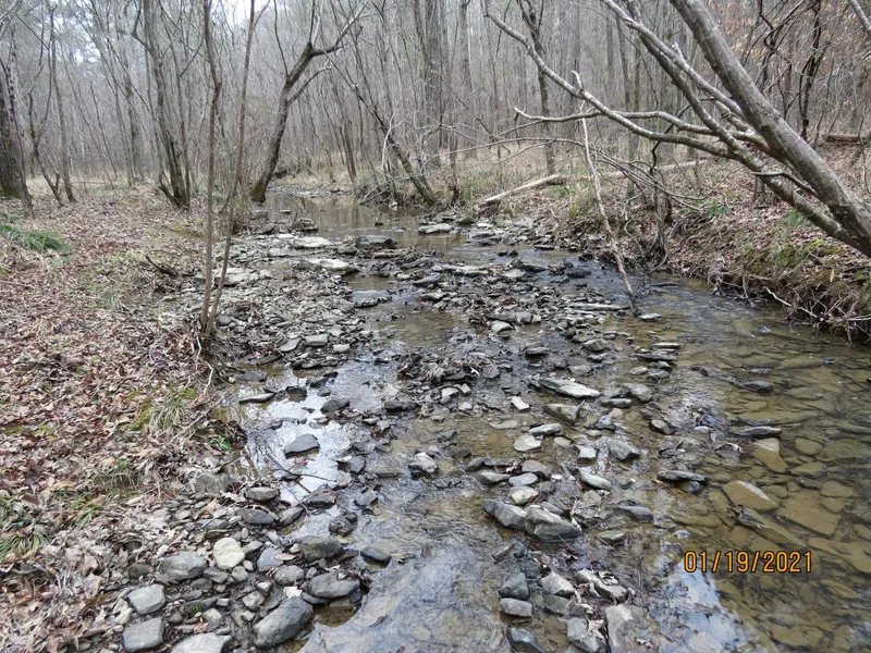
Un-surveyed estimates of the locations of the NW corner, the NE corner and the intersection of the west line with Black Creek are marked in pink flagging but are subject to independent verification.
Power available from the paved road. The nearest water main on McClendon Chapel Rd stops 3,400 feet to the west at Blackie Curren Rd
Beautiful mature hardwood timber
Several nice home sites on both parcels
Beautiful Black Creek (plus 2 other creeks) cross the property for about 1,800 feet
From elevation to risk assessment
Search for detailed parcel information including; Elevation & Vegetation Maps, Ownership Information, Detailed Parcel Information, Crop History Map, Soil Survey Productivity Data, and more.
Research Parcel InformationDirections
Directions from I-459 Exit #1 (Eastern Valley Road) at Bessemer: (12 minutes to the property)
From Exit #1, head south on Eastern Valley Road for about mile and take a left on to Ben Hill Road. Go 1.1 miles to Pocahontas Road and take a right. Go 2.5 miles (crossing over Shades Creek) and bear left onto McClendon Chapel Road. Continue 2.1 miles to the west line of the 78 acres (look for pink flagging). From here the 17-acre parcel is on your left for 3/10 of a mile, and the 61-acre property is on your right for 3/10 of a mile. Look for the Cyprus Partners sign. Entrances to the woods roads into the 17-acre and 61-acre parcels are marked in blue flagging (see topo map for locations). You are welcome to look on your own (download the brochure from the web site and use the topo map as a guide) or you can set up an appointment. The access road into the interior of the 61-acre tract is located at Lat: 33 17 13.3 N.; Lon: 86 56 34.2 W.
Environmental Factors
Resources
Jefferson County Properties By Type
- Undeveloped Land for Sale in Jefferson County, Alabama
- Farms for Sale in Jefferson County, Alabama
- Residential Property for Sale in Jefferson County, Alabama
- Lakefront Property for Sale in Jefferson County, Alabama
- Ranches for Sale in Jefferson County, Alabama
- Riverfront Property for Sale in Jefferson County, Alabama
- Commercial Property for Sale in Jefferson County, Alabama
- Hunting Land for Sale in Jefferson County, Alabama
- Recreational Property for Sale in Jefferson County, Alabama
- Horse Property for Sale in Jefferson County, Alabama
- Timberland for Sale in Jefferson County, Alabama
- Beachfront Property for Sale in Jefferson County, Alabama
Properties for Sale Nearby Counties
Jefferson County Properties By City
- Adamsville, Alabama Land for Sale
- Adger, Alabama Land for Sale
- Alton, Alabama Land for Sale
- Bessemer, Alabama Land for Sale
- Birmingham, Alabama Land for Sale
- Brookside, Alabama Land for Sale
- Cardiff, Alabama Land for Sale
- Clay, Alabama Land for Sale
- Docena, Alabama Land for Sale
- Dolomite, Alabama Land for Sale
- Dora, Alabama Land for Sale
- Fairfield, Alabama Land for Sale
- More
- Fultondale, Alabama Land for Sale
- Gardendale, Alabama Land for Sale
- Graysville, Alabama Land for Sale
- Kimberly, Alabama Land for Sale
- Leeds, Alabama Land for Sale
- Morris, Alabama Land for Sale
- Mount Olive, Alabama Land for Sale
- Mulga, Alabama Land for Sale
- New Castle, Alabama Land for Sale
- Palmerdale, Alabama Land for Sale
- Pinson, Alabama Land for Sale
- Pleasant Grove, Alabama Land for Sale
- Sayre, Alabama Land for Sale
- Shannon, Alabama Land for Sale
- Trafford, Alabama Land for Sale
- Trussville, Alabama Land for Sale
- Warrior, Alabama Land for Sale
- Watson, Alabama Land for Sale
- Alden, Alabama Land for Sale
- Avondale, Alabama Land for Sale
- Blossburg, Alabama Land for Sale
- Bluff Park, Alabama Land for Sale
- Brighton, Alabama Land for Sale
- Cahaba Heights, Alabama Land for Sale
- Center Point, Alabama Land for Sale
- Coalburg, Alabama Land for Sale
- Concord, Alabama Land for Sale
- Crestline Heights, Alabama Land for Sale
- English Village, Alabama Land for Sale
- Ensley, Alabama Land for Sale
- Forestdale, Alabama Land for Sale
- Fulton Springs, Alabama Land for Sale
- Grayson Valley, Alabama Land for Sale
- Homewood, Alabama Land for Sale
- Hoover, Alabama Land for Sale
- Hopewell, Alabama Land for Sale
- Hueytown, Alabama Land for Sale
- Huffman, Alabama Land for Sale
- Irondale, Alabama Land for Sale
- Jefferson Park, Alabama Land for Sale
- Lake View, Alabama Land for Sale
- Liberty Highlands, Alabama Land for Sale
- Maytown, Alabama Land for Sale
- Midfield, Alabama Land for Sale
- Mountain Brook, Alabama Land for Sale
- North Johns, Alabama Land for Sale
- Overton, Alabama Land for Sale
- Praco, Alabama Land for Sale
- Riverchase, Alabama Land for Sale
- Roebuck Plaza, Alabama Land for Sale
- Rose Hill, Alabama Land for Sale
- Ruffner, Alabama Land for Sale
- South Highlands, Alabama Land for Sale
- Sylvan Springs, Alabama Land for Sale
- Tarrant, Alabama Land for Sale
- Vestavia Hills, Alabama Land for Sale
- Wenonah, Alabama Land for Sale
- Whites Chapel, Alabama Land for Sale
- Abington Green, Alabama Land for Sale
- Acipcoville, Alabama Land for Sale
- Acton, Alabama Land for Sale
- Airport Highlands, Alabama Land for Sale
- Alliance, Alabama Land for Sale
- Altamont Park, Alabama Land for Sale
- Arbor Crossing, Alabama Land for Sale
- Argo, Alabama Land for Sale
- Arrowhead, Alabama Land for Sale
- Asbury Park, Alabama Land for Sale
- Autumn Chase, Alabama Land for Sale
- Avalon Park, Alabama Land for Sale
- Avon Park, Alabama Land for Sale
- Ayres, Alabama Land for Sale
- Bagley, Alabama Land for Sale
- Bagley Meadows, Alabama Land for Sale
- Barnisdale Forest, Alabama Land for Sale
- Bartonville, Alabama Land for Sale
- Battleground, Alabama Land for Sale
- Bay View, Alabama Land for Sale
- Beacon Hills, Alabama Land for Sale
- Belle Haven, Alabama Land for Sale
- Belle Terre, Alabama Land for Sale
- Beltona, Alabama Land for Sale
- Belwood, Alabama Land for Sale
- Bendale, Alabama Land for Sale
- Bentley Hills, Alabama Land for Sale
- Berney Points, Alabama Land for Sale
- Bessemer Gardens, Alabama Land for Sale
- Bessemer Homestead, Alabama Land for Sale
- Bessemer Junction, Alabama Land for Sale
- Bessie, Alabama Land for Sale
- Bessie Junction, Alabama Land for Sale
- Beverly Station, Alabama Land for Sale
- Biscayne Highlands, Alabama Land for Sale
- Black Diamond, Alabama Land for Sale
- Blue Creek, Alabama Land for Sale
- Blue Creek Junction, Alabama Land for Sale
- Bon-Air, Alabama Land for Sale
- Booker Heights, Alabama Land for Sale
- Boyles Highlands, Alabama Land for Sale
- Breakstone Village, Alabama Land for Sale
- Brents Cross Roads, Alabama Land for Sale
- Brentwood Hills, Alabama Land for Sale
- Brickyard Junction, Alabama Land for Sale
- Broadmoor, Alabama Land for Sale
- Brooklane Place, Alabama Land for Sale
- Brookmont, Alabama Land for Sale
- Brookview, Alabama Land for Sale
- Brownville, Alabama Land for Sale
- Buena Vista Highlands, Alabama Land for Sale
- Cahaba Cliffs, Alabama Land for Sale
- Cahaba Commons, Alabama Land for Sale
- Cahaba Cove, Alabama Land for Sale
- Cahaba Crest, Alabama Land for Sale
- Cahaba Hills, Alabama Land for Sale
- Cahaba Landing, Alabama Land for Sale
- Cahaba Oaks, Alabama Land for Sale
- Cahaba Village, Alabama Land for Sale
- Camden Place, Alabama Land for Sale
- Camelot Woods, Alabama Land for Sale
- Camp Horne, Alabama Land for Sale
- Candlewood Lakes, Alabama Land for Sale
- Cane Creek, Alabama Land for Sale
- Carriage Hills, Alabama Land for Sale
- Cedar Crest, Alabama Land for Sale
- Cedarbrook Forest, Alabama Land for Sale
- Center Point Gardens, Alabama Land for Sale
- Centercrest, Alabama Land for Sale
- Central Highlands, Alabama Land for Sale
- Central Park Highlands, Alabama Land for Sale
- Chalkville, Alabama Land for Sale
- Cherokee Bend, Alabama Land for Sale
- Cherokee Forest, Alabama Land for Sale
- Chestnut Ridge, Alabama Land for Sale
- Chetopa, Alabama Land for Sale
- Chimney Hills, Alabama Land for Sale
- Chinn, Alabama Land for Sale
- Circle Heights, Alabama Land for Sale
- Coaldale, Alabama Land for Sale
- Collins, Alabama Land for Sale
- Columbus, Alabama Land for Sale
- Corner, Alabama Land for Sale
- Cottage Hill, Alabama Land for Sale
- Cotton Ridge, Alabama Land for Sale
- Country Club Highlands, Alabama Land for Sale
- Country Haven, Alabama Land for Sale
- Countrywood Highlands, Alabama Land for Sale
- Coventry, Alabama Land for Sale
- Crescent Heights, Alabama Land for Sale
- Crest, Alabama Land for Sale
- Crestline Gardens, Alabama Land for Sale
- Crestline Park, Alabama Land for Sale
- Crestview Hills, Alabama Land for Sale
- Crockard Junction, Alabama Land for Sale
- Crocker Junction, Alabama Land for Sale
- Crossgate, Alabama Land for Sale
- Crosston, Alabama Land for Sale
- Crumley Chapel, Alabama Land for Sale
- Cullom Place, Alabama Land for Sale
- Daisey City, Alabama Land for Sale
- Dogtown, Alabama Land for Sale
- Dolonar, Alabama Land for Sale
- Dolonar Junction, Alabama Land for Sale
- Douglasville, Alabama Land for Sale
- Driftwood, Alabama Land for Sale
- Dunbarton Oaks, Alabama Land for Sale
- Duncan, Alabama Land for Sale
- Eagle Ridge, Alabama Land for Sale
- East Birmingham, Alabama Land for Sale
- East Boyles, Alabama Land for Sale
- East Brighton, Alabama Land for Sale
- East Irondale, Alabama Land for Sale
- East Thomas, Alabama Land for Sale
- East Thomas Gardens, Alabama Land for Sale
- Eastbrook Manor, Alabama Land for Sale
- Eastern Valley, Alabama Land for Sale
- Eastpointe, Alabama Land for Sale
- Echo Hills, Alabama Land for Sale
- Eden Ridge, Alabama Land for Sale
- Edgemont Park, Alabama Land for Sale
- Edgewater, Alabama Land for Sale
- Edgewater Junction, Alabama Land for Sale
- Edgewood, Alabama Land for Sale
- Elyton, Alabama Land for Sale
- Ensley Highlands, Alabama Land for Sale
- Ensley Junction, Alabama Land for Sale
- Exum, Alabama Land for Sale
- Ezra, Alabama Land for Sale
- Fairfield Highlands, Alabama Land for Sale
- Fairfield Village, Alabama Land for Sale
- Fairview, Alabama Land for Sale
- Falls Junction, Alabama Land for Sale
- Fieldstown, Alabama Land for Sale
- Five Points East, Alabama Land for Sale
- Five Points South, Alabama Land for Sale
- Flat Creek, Alabama Land for Sale
- Forest Acres, Alabama Land for Sale
- Forestdale by the Brook, Alabama Land for Sale
- Fountain Heights, Alabama Land for Sale
- Fox Trace, Alabama Land for Sale
- Frances Heights, Alabama Land for Sale
- Franklin Gardens, Alabama Land for Sale
- Frenchtown, Alabama Land for Sale
- Gable Cove, Alabama Land for Sale
- Garywood, Alabama Land for Sale
- Gate City, Alabama Land for Sale
- Gentilly Forest, Alabama Land for Sale
- Germania, Alabama Land for Sale
- Gilmore, Alabama Land for Sale
- Glen Hills, Alabama Land for Sale
- Glen Iris, Alabama Land for Sale
- Glendale, Alabama Land for Sale
- Glenview, Alabama Land for Sale
- Gordon Heights, Alabama Land for Sale
- Grants Mill, Alabama Land for Sale
- Grasselli, Alabama Land for Sale
- Graymont, Alabama Land for Sale
- Grays Gardens, Alabama Land for Sale
- Graysville Heights, Alabama Land for Sale
- Greenleas Heights, Alabama Land for Sale
- Hampton Place, Alabama Land for Sale
- Harlem Heights, Alabama Land for Sale
- Harriman Park, Alabama Land for Sale
- Havenview, Alabama Land for Sale
- Hayes Highland, Alabama Land for Sale
- Heatherwood, Alabama Land for Sale
- Hidden Ridge, Alabama Land for Sale
- High Point, Alabama Land for Sale
- Highland Crest, Alabama Land for Sale
- Highland Forest, Alabama Land for Sale
- Highland Residence Park, Alabama Land for Sale
- Highlands, Alabama Land for Sale
- Hillman, Alabama Land for Sale
- Hillman Gardens, Alabama Land for Sale
- Hillman Park, Alabama Land for Sale
- Hilltop, Alabama Land for Sale
- Hillview, Alabama Land for Sale
- Hoagtown, Alabama Land for Sale
- Holiday Gardens, Alabama Land for Sale
- Hooper City, Alabama Land for Sale
- Hopkins, Alabama Land for Sale
- Hudson Gardens, Alabama Land for Sale
- Hudson Grove, Alabama Land for Sale
- Hueytown Crest, Alabama Land for Sale
- Huffman Gardens, Alabama Land for Sale
- Humoro, Alabama Land for Sale
- Hunters Hill, Alabama Land for Sale
- Huntington Park, Alabama Land for Sale
- Hyde Park, Alabama Land for Sale
- Imperial Forest, Alabama Land for Sale
- Industrial City, Alabama Land for Sale
- Ingle Terrace, Alabama Land for Sale
- Inglenook, Alabama Land for Sale
- Innsbrooke, Alabama Land for Sale
- Interurban Heights, Alabama Land for Sale
- Ishkooda, Alabama Land for Sale
- Ivy Chase, Alabama Land for Sale
- Ivy Glenn, Alabama Land for Sale
- Jefferson Hills, Alabama Land for Sale
- Jet, Alabama Land for Sale
- Johns, Alabama Land for Sale
- Jones Valley, Alabama Land for Sale
- Jonesboro, Alabama Land for Sale
- Kenwood, Alabama Land for Sale
- Ketona, Alabama Land for Sale
- Kilgore, Alabama Land for Sale
- Killough Springs, Alabama Land for Sale
- Kimbrell, Alabama Land for Sale
- Kingsway Terrace, Alabama Land for Sale
- Labuco, Alabama Land for Sale
- Laceys Chapel, Alabama Land for Sale
- Lake Highlands, Alabama Land for Sale
- Lakeview Park, Alabama Land for Sale
- Lakewood Estate, Alabama Land for Sale
- Lakewood Hills, Alabama Land for Sale
- Larkwood, Alabama Land for Sale
- Lawsontown, Alabama Land for Sale
- Lewisburg, Alabama Land for Sale
- Linn Crossing, Alabama Land for Sale
- Linton, Alabama Land for Sale
- Lipscomb, Alabama Land for Sale
- Little Italy, Alabama Land for Sale
- Little Shoal, Alabama Land for Sale
- Littleton, Alabama Land for Sale
- Loch Haven, Alabama Land for Sale
- Lochridge, Alabama Land for Sale
- Lola City, Alabama Land for Sale
- Longleaf, Alabama Land for Sale
- Loveless Park, Alabama Land for Sale
- Lovick, Alabama Land for Sale
- Lowetown, Alabama Land for Sale
- Lynn Acres, Alabama Land for Sale
- Magnolia Courts, Alabama Land for Sale
- Magnolia Heights, Alabama Land for Sale
- Majestic, Alabama Land for Sale
- Marks Village, Alabama Land for Sale
- Martins, Alabama Land for Sale
- Mason City, Alabama Land for Sale
- Masseyline, Alabama Land for Sale
- Maxine, Alabama Land for Sale
- McAdory, Alabama Land for Sale
- McCalla, Alabama Land for Sale
- McCombs, Alabama Land for Sale
- McDonald Chapel, Alabama Land for Sale
- Meadwood Heights, Alabama Land for Sale
- Media, Alabama Land for Sale
- Merrywood, Alabama Land for Sale
- Mill Run, Alabama Land for Sale
- Mineral Springs, Alabama Land for Sale
- Minniesville, Alabama Land for Sale
- Minor, Alabama Land for Sale
- Mobile Junction, Alabama Land for Sale
- Monmouth, Alabama Land for Sale
- Montclair, Alabama Land for Sale
- Monte D'Oro, Alabama Land for Sale
- Monte-Sano, Alabama Land for Sale
- Montreat, Alabama Land for Sale
- Moore Corner, Alabama Land for Sale
- Morgan, Alabama Land for Sale
- Moss Rock, Alabama Land for Sale
- Mountain Brook Village, Alabama Land for Sale
- Mountain Forest, Alabama Land for Sale
- Mountain Oaks, Alabama Land for Sale
- Mountain Park, Alabama Land for Sale
- Mountain Woods Park, Alabama Land for Sale
- Mountaindale, Alabama Land for Sale
- Mud Creek, Alabama Land for Sale
- Mulga Mine, Alabama Land for Sale
- Muscoda, Alabama Land for Sale
- Nelson Heights, Alabama Land for Sale
- New Hill, Alabama Land for Sale
- New Town, Alabama Land for Sale
- New Village, Alabama Land for Sale
- Norris Junction, Alabama Land for Sale
- North Birmingham, Alabama Land for Sale
- North Highlands, Alabama Land for Sale
- North Lake Park, Alabama Land for Sale
- Nottingham, Alabama Land for Sale
- Oak Crossing, Alabama Land for Sale
- Oak Forest, Alabama Land for Sale
- Oak Hills, Alabama Land for Sale
- Oak Lawn, Alabama Land for Sale
- Oak Ridge Park, Alabama Land for Sale
- Oakhurst, Alabama Land for Sale
- Old Jonesboro, Alabama Land for Sale
- Old Leeds Forest, Alabama Land for Sale
- Overton Manor, Alabama Land for Sale
- Owenton, Alabama Land for Sale
- Oxmoor, Alabama Land for Sale
- Palos, Alabama Land for Sale
- Panorama, Alabama Land for Sale
- Park Courts, Alabama Land for Sale
- Park Place, Alabama Land for Sale
- Parker Heights, Alabama Land for Sale
- Parkwood Hills, Alabama Land for Sale
- Partridge Crossroads, Alabama Land for Sale
- Patton Chapel, Alabama Land for Sale
- Pauls Hill, Alabama Land for Sale
- Pawnee Heights, Alabama Land for Sale
- Penfield Heights, Alabama Land for Sale
- Petes Crossroads, Alabama Land for Sale
- Phoenixville, Alabama Land for Sale
- Pine Crest, Alabama Land for Sale
- Pine Knoll Vista, Alabama Land for Sale
- Pineland Park, Alabama Land for Sale
- Pinkney City, Alabama Land for Sale
- Plain View, Alabama Land for Sale
- Plantation Point, Alabama Land for Sale
- Pleasant Acres, Alabama Land for Sale
- Polo Trace, Alabama Land for Sale
- Port Birmingham, Alabama Land for Sale
- Porter, Alabama Land for Sale
- Powderly, Alabama Land for Sale
- Powderly Hills, Alabama Land for Sale
- Powhatan, Alabama Land for Sale
- Pratt City, Alabama Land for Sale
- Queenstown, Alabama Land for Sale
- Quintown, Alabama Land for Sale
- Raimund, Alabama Land for Sale
- Red Hill Heights, Alabama Land for Sale
- Red Wine, Alabama Land for Sale
- Redmont Park, Alabama Land for Sale
- Republic, Alabama Land for Sale
- Richmond Place, Alabama Land for Sale
- Ridgecrest, Alabama Land for Sale
- Robbins Crossroads, Alabama Land for Sale
- Rock Creek, Alabama Land for Sale
- Rock Ridge, Alabama Land for Sale
- Rocky Bridge, Alabama Land for Sale
- Rocky Ridge Manor, Alabama Land for Sale
- Roebuck Forest, Alabama Land for Sale
- Roebuck Gardens, Alabama Land for Sale
- Roebuck Park, Alabama Land for Sale
- Roebuck Springs, Alabama Land for Sale
- Roebuck Terrace, Alabama Land for Sale
- Rolling Hills, Alabama Land for Sale
- Rolling Ridge, Alabama Land for Sale
- Roosevelt, Alabama Land for Sale
- Roosevelt-Cairo Village, Alabama Land for Sale
- Roper, Alabama Land for Sale
- Russell Heights, Alabama Land for Sale
- Russet Woods, Alabama Land for Sale
- Rutledge Springs, Alabama Land for Sale
- Saddlebrook, Alabama Land for Sale
- Saddlewood, Alabama Land for Sale
- Sagewood, Alabama Land for Sale
- Sandusky, Alabama Land for Sale
- Sayreton, Alabama Land for Sale
- Scarlet Town, Alabama Land for Sale
- Scott City, Alabama Land for Sale
- Self Creek, Alabama Land for Sale
- Seloca, Alabama Land for Sale
- Shades Acres, Alabama Land for Sale
- Shades Cliff, Alabama Land for Sale
- Shades Run, Alabama Land for Sale
- Shady Brook, Alabama Land for Sale
- Shadyside, Alabama Land for Sale
- Shadywood, Alabama Land for Sale
- Sherman Oaks, Alabama Land for Sale
- Sherwood Hills, Alabama Land for Sale
- Short Creek, Alabama Land for Sale
- Sky Ranch, Alabama Land for Sale
- Skyview, Alabama Land for Sale
- Sloss, Alabama Land for Sale
- Smith Highlands, Alabama Land for Sale
- Smithfield, Alabama Land for Sale
- Smithson, Alabama Land for Sale
- Snowtown, Alabama Land for Sale
- South Vestavia Hills, Alabama Land for Sale
- Southern Acres, Alabama Land for Sale
- Southridge, Alabama Land for Sale
- Spaulding, Alabama Land for Sale
- Springdale, Alabama Land for Sale
- Stonebrook Park, Alabama Land for Sale
- Stonehedge, Alabama Land for Sale
- Stoneridge, Alabama Land for Sale
- Sueann, Alabama Land for Sale
- Summit Farm, Alabama Land for Sale
- Sumter, Alabama Land for Sale
- Sun Valley, Alabama Land for Sale
- Sunnyside, Alabama Land for Sale
- Sunrise East, Alabama Land for Sale
- Sunset Mountain, Alabama Land for Sale
- Surrey Hill, Alabama Land for Sale
- Tangle Creek, Alabama Land for Sale
- Tanglewood, Alabama Land for Sale
- Tarpley, Alabama Land for Sale
- Tarrant Heights, Alabama Land for Sale
- The Drifttracks, Alabama Land for Sale
- Thomas, Alabama Land for Sale
- Thomas Acres, Alabama Land for Sale
- Thornhill, Alabama Land for Sale
- Timber Ridge, Alabama Land for Sale
- Timbercrest, Alabama Land for Sale
- Toadvine, Alabama Land for Sale
- Trotwood Park, Alabama Land for Sale
- Trussville Manor, Alabama Land for Sale
- Tutwiler Farm, Alabama Land for Sale
- Tuxedo Heights, Alabama Land for Sale
- Twin Bridge, Alabama Land for Sale
- Upper Coalburg, Alabama Land for Sale
- Valhalla, Alabama Land for Sale
- Valley Creek, Alabama Land for Sale
- Vanderbilt, Alabama Land for Sale
- Vanns, Alabama Land for Sale
- Verdue Knolls, Alabama Land for Sale
- Vestavia Forest, Alabama Land for Sale
- Vestavia Lake, Alabama Land for Sale
- Vestbrook Trace, Alabama Land for Sale
- Vestridge, Alabama Land for Sale
- Vestwood Hills, Alabama Land for Sale
- Village Creek, Alabama Land for Sale
- Village Creek Junction, Alabama Land for Sale
- Village Springs, Alabama Land for Sale
- Vineland Park, Alabama Land for Sale
- Vines Mill, Alabama Land for Sale
- Virginia, Alabama Land for Sale
- Von Dale, Alabama Land for Sale
- Vulcan, Alabama Land for Sale
- Vulcan City, Alabama Land for Sale
- Wahouma, Alabama Land for Sale
- Walker Chapel, Alabama Land for Sale
- Ware, Alabama Land for Sale
- Washington Heights, Alabama Land for Sale
- Watkins Glen, Alabama Land for Sale
- Weems, Alabama Land for Sale
- Wegra, Alabama Land for Sale
- Weller, Alabama Land for Sale
- Wellington Park, Alabama Land for Sale
- West Ensley, Alabama Land for Sale
- West Fairfield, Alabama Land for Sale
- West Highlands, Alabama Land for Sale
- West Lake Highlands, Alabama Land for Sale
- West Ridge, Alabama Land for Sale
- West Sayre, Alabama Land for Sale
- Westbrook Trace, Alabama Land for Sale
- Westwood, Alabama Land for Sale
- Wheeling Crossroad, Alabama Land for Sale
- Whispering Oaks, Alabama Land for Sale
- White Oaks, Alabama Land for Sale
- Wilderness Garden, Alabama Land for Sale
- Wilkes, Alabama Land for Sale
- Williamsburg, Alabama Land for Sale
- Windsor Highlands, Alabama Land for Sale
- Wine Ridge, Alabama Land for Sale
- Winetka, Alabama Land for Sale
- Wisteria Commons, Alabama Land for Sale
- Woodcrest, Alabama Land for Sale
- Woodlawn, Alabama Land for Sale
- Woodmeadows, Alabama Land for Sale
- Woodward, Alabama Land for Sale
- Woodward Junction, Alabama Land for Sale
- Wylam, Alabama Land for Sale
- Zion City, Alabama Land for Sale
- Zion Heights, Alabama Land for Sale