Super Sized! 8 acres Among Rolling Hills near Pike Forest!
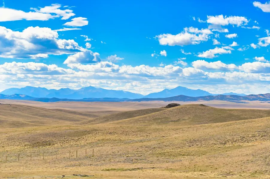
Find your peace and quiet on this larger than average 8 acre parcel located about 18 miles south of Hartsel! Take in the beauty of the area with incredible views of the snow capped mountains off to the west and rolling hills all around the property. The property itself features some gentle slopes with the highest point on the north side of the property where you will find the best 360 degree views. There are plenty of flatter spots as well for setting up your base camp or future off grid cabin. With Pike Forest just a couple miles east and plenty of wide open space, this is an outdoorsmans dream with a variety of game right at your fingertips!
Owner financing available on all properties and everyone qualifies. We also include a 15% prepayment discount if you want to pay off early and save! Contact us or check out our site for more information on available options.
SUBDIVISION: ESTATES OF COLORADO
ADDRESS: 439 BLACK BEAVER CIR, HARTSEL, CO 80449
SIZE: 8 acres
APN: 9524
LEGAL DESCRIPTION: Lot 4508, Estates of Colorado Unit 89, County of Park, State of Colorado.
APPROX. GPS COORDINATES:
NW: 38.824962, -105.731998
NE: 38.824989, -105.728825
E: 38.824289, -105.730303
SE: 38.823759, -105.730328
SW: 38.823867, -105.732013
APPROX. ELEVATION: 9,712 ft
ZONING: Residential
CAMPING & RVs: Both RV and Tent Short Term
IMPROVEMENTS: None
ANNUAL TAXES: Approx. $123
HOA/POA FEES: None
SEWER: Would need septic system if building.
WATER: Would be by well, holding tank or other similar option.
UTILITIES: Solar or generator best options for electricity. Gas by propane tank. Phone by cellular.
ACCESS: County dirt road. Accessible by car weather permitting or with four-wheel drive vehicle in inclement weather.
From elevation to risk assessment
Search for detailed parcel information including; Elevation & Vegetation Maps, Ownership Information, Detailed Parcel Information, Crop History Map, Soil Survey Productivity Data, and more.
Research Parcel InformationDirections
From Hartsel:
Turn right onto CO-9 S and continue for 2.0 miles.
Turn right onto Co Rd 53 and drive for 13.6 miles.
Keep left to continue on Pawnee Trail for 0.7 miles.
Continue onto Es25/Watonga Rd and continue to follow Watonga Rd for 1.2 miles.
Turn left onto Wigwam Trail and drive for 0.5 miles.
Turn left onto Black Beaver Rd. Your destination will be on the left after 0.5 miles.
Environmental Factors
Resources
Land for Sale by Adam Wilkerson
Park County Properties By Type
- Undeveloped Land for Sale in Park County, Colorado
- Ranches for Sale in Park County, Colorado
- Residential Property for Sale in Park County, Colorado
- Riverfront Property for Sale in Park County, Colorado
- Lakefront Property for Sale in Park County, Colorado
- Beachfront Property for Sale in Park County, Colorado
- Hunting Land for Sale in Park County, Colorado
- Farms for Sale in Park County, Colorado
- Horse Property for Sale in Park County, Colorado
- Recreational Property for Sale in Park County, Colorado
- Timberland for Sale in Park County, Colorado
- Commercial Property for Sale in Park County, Colorado
Properties for Sale Nearby Counties
Park County Properties By City
- Alma, Colorado Land for Sale
- Bailey, Colorado Land for Sale
- Como, Colorado Land for Sale
- Fairplay, Colorado Land for Sale
- Grant, Colorado Land for Sale
- Guffey, Colorado Land for Sale
- Hartsel, Colorado Land for Sale
- Jefferson, Colorado Land for Sale
- Lake George, Colorado Land for Sale
- Shawnee, Colorado Land for Sale
- Tarryall, Colorado Land for Sale
- Alma Junction, Colorado Land for Sale
- More
- Antero Junction, Colorado Land for Sale
- Balfour, Colorado Land for Sale
- Bordenville, Colorado Land for Sale
- Estabrook, Colorado Land for Sale
- Garo, Colorado Land for Sale
- Glenisle, Colorado Land for Sale
- Glentivar, Colorado Land for Sale
- Haver, Colorado Land for Sale
- Insmont, Colorado Land for Sale
- Peabodys, Colorado Land for Sale
- Pike-San Isabel Village, Colorado Land for Sale
- Platte Springs, Colorado Land for Sale
- Santa Maria, Colorado Land for Sale
- Singleton, Colorado Land for Sale
- Trump, Colorado Land for Sale
- Webster, Colorado Land for Sale
- Weller, Colorado Land for Sale
- Will-O-The-Wisp, Colorado Land for Sale