Auction Information
Blue Earth Co., MN-155 Ac., m/l (190-0031)
1450 Adams St. , Mankato, MN
Start Date: 09/10/2021, 10:00 AM
Blue Earth Co., MN-80 Ac., m/l (190-0031-02)
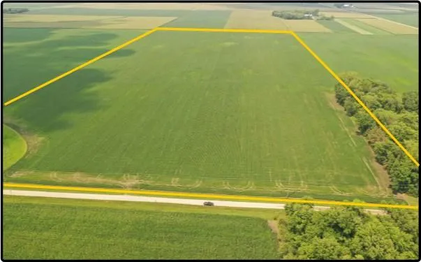
80.00 acres, m/l, located approximately 7 miles southeast of Mapleton, Minnesota on the north side of 121st St.
This level to gently sloping farm has 75.47 FSA/Eff. crop acres with a CPI of 87.20.
This is a prime southern Minnesota farm with excellent farming configuration and road access.
From elevation to risk assessment
Search for detailed parcel information including; Elevation & Vegetation Maps, Ownership Information, Detailed Parcel Information, Crop History Map, Soil Survey Productivity Data, and more.
Research Parcel InformationDirections
From Mapleton: Go east on Highway 21
for 6 miles to 620th Avenue. Head south
for 2 miles, then east on 121st Street for
mile. Property is on the north side of the
road.
Resources
Contact Seller
Listing provided by
Hertz Real Estate Services
Hertz Real Estate Services(309) 326-7672
Listing last updated: February 7, 2022 at 5:43 AM
Report this listing
Land for Sale by Hertz Real Estate Services
Blue Earth County Properties By Type
- Farms for Sale in Blue Earth County, Minnesota
- Lakefront Property for Sale in Blue Earth County, Minnesota
- Riverfront Property for Sale in Blue Earth County, Minnesota
- Hunting Land for Sale in Blue Earth County, Minnesota
- Commercial Property for Sale in Blue Earth County, Minnesota
- Undeveloped Land for Sale in Blue Earth County, Minnesota
- Residential Property for Sale in Blue Earth County, Minnesota
- Recreational Property for Sale in Blue Earth County, Minnesota
- Timberland for Sale in Blue Earth County, Minnesota
- Horse Property for Sale in Blue Earth County, Minnesota
- Ranches for Sale in Blue Earth County, Minnesota
- Beachfront Property for Sale in Blue Earth County, Minnesota
Properties for Sale Nearby Counties
Blue Earth County Properties By City
- Amboy, Minnesota Land for Sale
- Eagle Lake, Minnesota Land for Sale
- Garden City, Minnesota Land for Sale
- Good Thunder, Minnesota Land for Sale
- Lake Crystal, Minnesota Land for Sale
- Madison Lake, Minnesota Land for Sale
- Mankato, Minnesota Land for Sale
- Mapleton, Minnesota Land for Sale
- Pemberton, Minnesota Land for Sale
- Saint Clair, Minnesota Land for Sale
- Vernon Center, Minnesota Land for Sale
- Beauford, Minnesota Land for Sale
- More
- Belle Haven, Minnesota Land for Sale
- Benning, Minnesota Land for Sale
- Butternut, Minnesota Land for Sale
- Cambria, Minnesota Land for Sale
- Eagle Lake Regency, Minnesota Land for Sale
- Judson, Minnesota Land for Sale
- LeHillier, Minnesota Land for Sale
- Perth, Minnesota Land for Sale
- Pleasant Hill Manor, Minnesota Land for Sale
- Rapidan, Minnesota Land for Sale
- Skyline, Minnesota Land for Sale
- Sterling Center, Minnesota Land for Sale
- University Park of Mankato, Minnesota Land for Sale
- Willow Creek, Minnesota Land for Sale