The Ranken Farm
Location: The subject farm is located approximately 63 miles west of Chicago O'Hare International Airport. Nearby cities include: Rochelle (1 1/2 miles northeast), Amboy (13 1/8 miles southwest), and DeKalb (18 1/2 miles east).
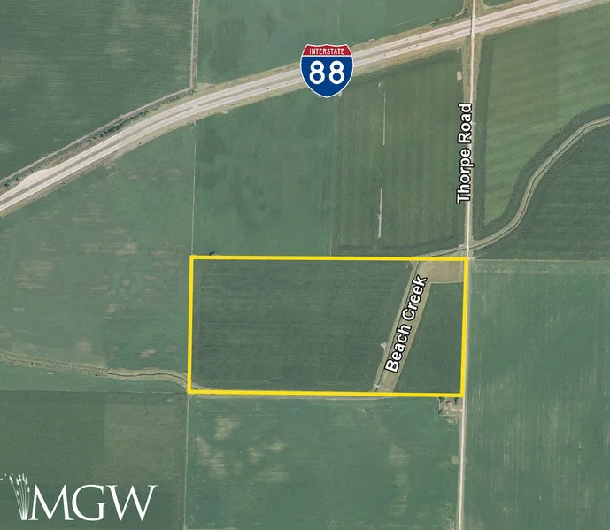
Frontage: There is approximately 1/4 mile of road frontage on Thorpe Road.
Major Highways: Interstate 88 is 1/4 mile north, Illinois Route 38 is 2 1/2 miles north, Illinois Route 251 is 3 miles east, Interstate 39/ U.S. Route 51 is 6 1/4 miles east, and U.S. Route 30 is 7 3/4 miles south of the property.
Legal Description: A brief legal description indicates The Ranken Farm is located in The North Half of the Northeast Quarter of Section 8, Township 39 North - Range 1 East (Reynolds Township), Lee County, Illinois.
Total Acres: There are a total of 80 acres, more or less, according to the Lee County Assessor.
Tillable Acres: There are approximately 78.69 cropland acres according to the Lee County FSA, of which 7.72 acres are currently enrolled in CRP with an annual contract payment of $2,835 through September 30, 2026.
Soil Types: Drummer silty clay loam is the primary soil type on this farm.
Topography: The topography of the subject farm is level.
Mineral Rights: All mineral rights owned by the seller will be transferred in their entirety to the new owner.
Possession: Possession will be given at closing, subject to the terms and conditions set forth in a purchase contract.
Price Terms: The asking price is $12,950 per acre. A 10% earnest money deposit should accompany any offer to purchase.
Financing: Mortgage financing is available from several sources. Names and addresses will be provided upon request.
Taxes: The 2024 real estate taxes totaled $3,806.88. The tax parcel number is #17-05-08-200-001.
Grain Markets: There are a number of grain markets located within 15 miles of The Ranken Farm.
Zoning: The property is zoned AG-1, Rural/Agricultural District.
From elevation to risk assessment
Search for detailed parcel information including; Elevation & Vegetation Maps, Ownership Information, Detailed Parcel Information, Crop History Map, Soil Survey Productivity Data, and more.
Research Parcel InformationDirections
The farm's GPS coordinates are 41.875301, -89.131486, and can be copied and pasted into a mapping application for directions.
Environmental Factors
Resources
Land for Sale by Mark Mommsen
Lee County Properties By Type
- Farms for Sale in Lee County, Illinois
- Residential Property for Sale in Lee County, Illinois
- Ranches for Sale in Lee County, Illinois
- Recreational Property for Sale in Lee County, Illinois
- Undeveloped Land for Sale in Lee County, Illinois
- Lakefront Property for Sale in Lee County, Illinois
- Horse Property for Sale in Lee County, Illinois
- Timberland for Sale in Lee County, Illinois
- Riverfront Property for Sale in Lee County, Illinois
- Hunting Land for Sale in Lee County, Illinois
- Commercial Property for Sale in Lee County, Illinois
- Beachfront Property for Sale in Lee County, Illinois
Properties for Sale Nearby Counties
Lee County Properties By City
- Amboy, Illinois Land for Sale
- Ashton, Illinois Land for Sale
- Compton, Illinois Land for Sale
- Dixon, Illinois Land for Sale
- Eldena, Illinois Land for Sale
- Franklin Grove, Illinois Land for Sale
- Harmon, Illinois Land for Sale
- Lee, Illinois Land for Sale
- Lee Center, Illinois Land for Sale
- Nachusa, Illinois Land for Sale
- Paw Paw, Illinois Land for Sale
- Steward, Illinois Land for Sale
- More
- Sublette, Illinois Land for Sale
- West Brooklyn, Illinois Land for Sale
- Binghampton, Illinois Land for Sale
- Maytown, Illinois Land for Sale
- Nelson, Illinois Land for Sale
- Prairieville, Illinois Land for Sale
- Scarboro, Illinois Land for Sale
- Shaws, Illinois Land for Sale
- The Burg, Illinois Land for Sale
- Walton, Illinois Land for Sale
- Henkel, Illinois Land for Sale
- Inlet, Illinois Land for Sale
- Kingdom, Illinois Land for Sale
- Lincoln Heights, Illinois Land for Sale
- Radley, Illinois Land for Sale
- Roxbury, Illinois Land for Sale
- South Paw Paw, Illinois Land for Sale
- Twelvemile Corner, Illinois Land for Sale
- Van Petten, Illinois Land for Sale
- Woodland Shores, Illinois Land for Sale
