Auction Information
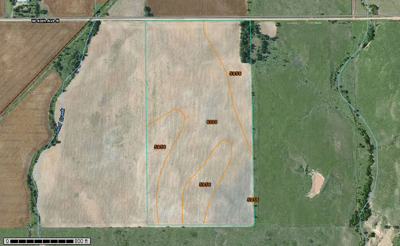
80 acres in Sumner County, Kansas
AUCTION FEB 24, 2014 at 7:00 P.M. - SUMNER COUNTY, KS
AUCTION LOCATION: Conway Springs City Building, Conway Springs, KS
Legal Description: A tract beginning at the Northwest corner of the Northeast Quarter of Section 35, Township 31 South, Range 4 West of the 6th P.M., Sumner County, Kansas, thence North 89 deg. 39 min. 55 sec. East along the North line of said Quarter Section, 1214 feet, thence South 0 deg. 12 min. 21 sec East, 549.71 feet, thence South 81 deg. 10 min. 51 sec. East 137.90 feet, thence South 1 deg. 30 min. 27 sec. East, 2073.65 feet to the South line of said Quarter Section, thence South 89 deg. 36 min. 15 sec. West along the South line of said Quarter Section, 1366.12 feet to the Southwest corner of said Quarter Section, thence North 0 deg. 53 min. 15 sec. West, along the West line of said Quarter Section, 2646.44 feet to the point of beginning, containing 80.43 acres, more or less.
Description: Approximately 80 acres with 79.53 acres of cultivation with a full wheat base and a 29 bu. yield. Soils are Class II and are Shellaburger sandy loam and Carwile fine sandy loam.
Possession: Buyer shall receive 1/3 of the growing wheat and shall be responsible for 1/3 of the fertilizer, chemical and crop insurance. Buyer shall receive possession of land immediately after wheat harvest.
Taxes: $277.74 taxes for 2014 will be the responsibility of the Buyer.
Minerals: 1/2 of the minerals shall go to Buyer.
Terms: 10% earnest money day of auction, balance to be paid by cashier's check on or before March 24, 2014. The Buyer and Seller shall share equally in the title insurance premium and closing cost. All announcements day of auction take precedence over all printed advertising.
From elevation to risk assessment
Search for detailed parcel information including; Elevation & Vegetation Maps, Ownership Information, Detailed Parcel Information, Crop History Map, Soil Survey Productivity Data, and more.
Research Parcel InformationDirections
From Conway Springs, KS go 5 miles south to 40th Ave. turn west and go 4 1/4 miles.
Resources
Land for Sale by Gene Francis
Sumner County Properties By Type
- Farms for Sale in Sumner County, Kansas
- Ranches for Sale in Sumner County, Kansas
- Hunting Land for Sale in Sumner County, Kansas
- Undeveloped Land for Sale in Sumner County, Kansas
- Recreational Property for Sale in Sumner County, Kansas
- Commercial Property for Sale in Sumner County, Kansas
- Residential Property for Sale in Sumner County, Kansas
- Lakefront Property for Sale in Sumner County, Kansas
- Riverfront Property for Sale in Sumner County, Kansas
- Horse Property for Sale in Sumner County, Kansas
- Timberland for Sale in Sumner County, Kansas
- Beachfront Property for Sale in Sumner County, Kansas
Properties for Sale Nearby Counties
Sumner County Properties By City
- Argonia, Kansas Land for Sale
- Belle Plaine, Kansas Land for Sale
- Caldwell, Kansas Land for Sale
- Conway Springs, Kansas Land for Sale
- Geuda Springs, Kansas Land for Sale
- Mayfield, Kansas Land for Sale
- Milan, Kansas Land for Sale
- Milton, Kansas Land for Sale
- Oxford, Kansas Land for Sale
- Peck, Kansas Land for Sale
- South Haven, Kansas Land for Sale
- Wellington, Kansas Land for Sale
- More
- Ashton, Kansas Land for Sale
- Corbin, Kansas Land for Sale
- Hunnewell, Kansas Land for Sale
- Riverdale, Kansas Land for Sale
- Adamsville, Kansas Land for Sale
- Anson, Kansas Land for Sale
- Bushnell, Kansas Land for Sale
- Cicero, Kansas Land for Sale
- Dalton, Kansas Land for Sale
- Doster, Kansas Land for Sale
- Drury, Kansas Land for Sale
- Ewell, Kansas Land for Sale
- Metcalf, Kansas Land for Sale
- Millerton, Kansas Land for Sale
- Paton, Kansas Land for Sale
- Perth, Kansas Land for Sale
- Portland, Kansas Land for Sale
- Roland, Kansas Land for Sale
- Whitman, Kansas Land for Sale
- Zyba, Kansas Land for Sale