Auction Information
Martin Co., MN – 155.94 Ac., m/l (190-0040)
21 E. First St. , Sherburn , MN
Start Date: 11/05/2021, 10:00 AM
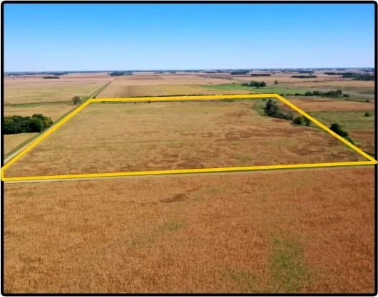
Martin Co., MN 81.30 Ac., m/l (190-0040-02)
81.30 acres, m/l, located approximately 6 miles west of Sherburn, Minnesota on the south side of 120th St.
This level to gently rolling farm has 70.41 FSA/Eff. crop acres with a CPI of 83.00.
Only Registered Bidders May Attend Auction
From elevation to risk assessment
Search for detailed parcel information including; Elevation & Vegetation Maps, Ownership Information, Detailed Parcel Information, Crop History Map, Soil Survey Productivity Data, and more.
Research Parcel InformationDirections
From Sherburn: go north on N. Main St.
for mile, then west on 120th St. for 6
miles. Property will be south of 120th St.
and east of 10th Ave.
Resources
Contact Seller
Listing provided by
Hertz Real Estate Services
Hertz Real Estate Services(309) 326-7672
Listing last updated: July 19, 2022 at 9:33 AM
Report this listing
Land for Sale by Hertz Real Estate Services
Martin County Properties By Type
- Farms for Sale in Martin County, Minnesota
- Lakefront Property for Sale in Martin County, Minnesota
- Commercial Property for Sale in Martin County, Minnesota
- Hunting Land for Sale in Martin County, Minnesota
- Ranches for Sale in Martin County, Minnesota
- Undeveloped Land for Sale in Martin County, Minnesota
- Residential Property for Sale in Martin County, Minnesota
- Recreational Property for Sale in Martin County, Minnesota
- Timberland for Sale in Martin County, Minnesota
- Horse Property for Sale in Martin County, Minnesota
- Beachfront Property for Sale in Martin County, Minnesota
- Riverfront Property for Sale in Martin County, Minnesota
Properties for Sale Nearby Counties
Martin County Properties By City
- Ceylon, Minnesota Land for Sale
- Dunnell, Minnesota Land for Sale
- Fairmont, Minnesota Land for Sale
- Granada, Minnesota Land for Sale
- Northrop, Minnesota Land for Sale
- Ormsby, Minnesota Land for Sale
- Sherburn, Minnesota Land for Sale
- Trimont, Minnesota Land for Sale
- Truman, Minnesota Land for Sale
- Welcome, Minnesota Land for Sale
- East Chain, Minnesota Land for Sale
- Fox Lake, Minnesota Land for Sale
- More