Auction Information

81.62 acres in Black Hawk County, Iowa
Description
Live and Online at Ranchandfarmauctions
Auction Date: 12/15/2025 Auction Time:1:00 PM CT
Auction Held At:Oakleaf Golf & Country Club, 29725 Diagonal Rd, Reinbeck, IA 50669
Entire Farm Description:
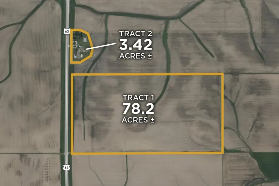
Ranch and Farm Auctions is proud to represent the Thomas Kerr Trust and Community Bank and Trust on this high-quality farm in Black Hawk County. This unique offering includes two tracts located just south of Hudson, Iowa, with exceptional access to Highway 20 and nearby grain facilities. Tract 1 features 78 acres, nearly all tillable, with a premium CSR2 soil rating of 94.22, and lies along hard-surfaced S Hudson Road. There is a lease in place through the 2025 crop season, with open tenancy available for 2026, making this an ideal farm for investors or owner-operators seeking high-quality farmland in a prime location. Tract 2 consists of 3.42 acres with a charming 1920-built home featuring 3 bedrooms, 1.5 baths, and 1,860 square feet of living space. Surrounded by multiple outbuildings, including a 40x60 machine shed and a 42x74 barn, this acreage offers outstanding storage or rental potential. Conveniently located just 5 miles south of Hudson, 12 miles from the University of Northern Iowa, and 15 miles from downtown Cedar Falls, this is a rare opportunity to acquire quality farmland and a well-located acreage. Join us in person or online for the auction.
81.62acres Black Hawk County Iowa Farmstead and Land Auction
77 FSA Tillable Acres
Offered in 2 tracts
Tract 1 78.2 acres with a CSR2 of 94.22
Tract 2 3.42 acres and includes a 1,860 SF home and numerous outbuildings
Located on a hard surface, S Hudson Rd
2 miles from a grain elevator, 9 miles from Highway 20, and 12 miles from the University of Northern Iowa
Representing Attorney:
McCrindle Law Firm, Attn: John Harris
607 Sycamore Street, Ste 500
Waterloo, IA 50703
319-234-0535
Tract 1 Description:
Tract 1 is 78.2 acres, with 77 FSA tillable acres. The property is located on hard-surfaced S Hudson Rd, straight south of Hudson, Iowa. The farm has a premium CSR2 soil rating of 94.22 with primary soil types of Dinsmore silty clay loam, Klingmore silty clay loam, and Maxmore silty clay loam. The property is 10 miles from Highway 20 and only 2 miles to the nearest grain elevator. There is a lease in place through the 2025 crop season, but open tenancy for the 2026 growing season. This is a very high-quality tillable farm in a great location. Join us in person or online for the auction.
Tract #: 1
Deeded Acres: 78.2
FSA Farmland Acres: 77
Soil Types: Dinsmore silty clay loam, Klingmore silty clay loam, Maxmore silty clay loam, Dinsdale silty clay loam, Maxfield silty clay loam
Soil PI/NCCPI/CSR2: 94.22
CRP Acres/Payment: NA
Taxes: $3,533
Lease Status: Open Tenancy for 2026 crop year
Possession: At Closing
Survey Needed?: No
Brief Legal: SW NW EXC HWY B 499 P 436 SEC 23 T 87 R 14 and SE NW SEC 23 T 87 R 14
PIDs: 871423151001, 871423176001
Lat/Lon: 42.336, -92.454
Zip Code: 50643
Tract 2 Description:
Tract 2 is a great little acreage on a hard-surfaced road. Sitting on 3.42 net acres, the home was built in 1920 with 3 beds, 1.5 baths and 1,860 square feet. Numerous outbuildings surround the home, including a 40x60 machine shed and a 42x74 barn, offering plenty of space for storage or rental opportunities. Located only 5 miles south of Hudson, 12 miles from the University of Northern Iowa, and 15 miles from downtown Cedar Falls. For someone looking for a rental opportunity, more storage space, or to move outside of town, come and check out this property.
Tract #: 2
Deeded Acres: 3.42
Taxes: TBD
Possession: At Closing
Survey Needed?: No
Lat/Lon: 42.3386, -92.4555
Zip Code: 50643
From elevation to risk assessment
Search for detailed parcel information including; Elevation & Vegetation Maps, Ownership Information, Detailed Parcel Information, Crop History Map, Soil Survey Productivity Data, and more.
Research Parcel InformationEnvironmental Factors
Resources
Black Hawk County Properties By Type
- Farms for Sale in Black Hawk County, Iowa
- Hunting Land for Sale in Black Hawk County, Iowa
- Undeveloped Land for Sale in Black Hawk County, Iowa
- Residential Property for Sale in Black Hawk County, Iowa
- Commercial Property for Sale in Black Hawk County, Iowa
- Timberland for Sale in Black Hawk County, Iowa
- Lakefront Property for Sale in Black Hawk County, Iowa
- Recreational Property for Sale in Black Hawk County, Iowa
- Riverfront Property for Sale in Black Hawk County, Iowa
- Horse Property for Sale in Black Hawk County, Iowa
- Ranches for Sale in Black Hawk County, Iowa
- Beachfront Property for Sale in Black Hawk County, Iowa
Properties for Sale Nearby Counties
Black Hawk County Properties By City
- Cedar Falls, Iowa Land for Sale
- Dewar, Iowa Land for Sale
- Dunkerton, Iowa Land for Sale
- Evansdale, Iowa Land for Sale
- Gilbertville, Iowa Land for Sale
- Hudson, Iowa Land for Sale
- La Porte City, Iowa Land for Sale
- Raymond, Iowa Land for Sale
- Waterloo, Iowa Land for Sale
- Cedar City, Iowa Land for Sale
- Elk Run Heights, Iowa Land for Sale
- Finchford, Iowa Land for Sale
- More
- North Cedar, Iowa Land for Sale
- Raymar, Iowa Land for Sale
- Voorhies, Iowa Land for Sale
- Washburn, Iowa Land for Sale
- Armour, Iowa Land for Sale
- Benson, Iowa Land for Sale
- Blessing, Iowa Land for Sale
- Boies, Iowa Land for Sale
- Canfield, Iowa Land for Sale
- Castle Hill, Iowa Land for Sale
- Cedar Falls Junction, Iowa Land for Sale
- Cedar Knoll Park, Iowa Land for Sale
- Eagle Center, Iowa Land for Sale
- Eastgate Estate Park, Iowa Land for Sale
- Hilltop, Iowa Land for Sale
- Jubilee, Iowa Land for Sale
- Lamplighter Villa, Iowa Land for Sale
- Louise, Iowa Land for Sale
- Norris Siding, Iowa Land for Sale
- Orange, Iowa Land for Sale