Rolling Acreage Tract with Pasture, Timber & Creek
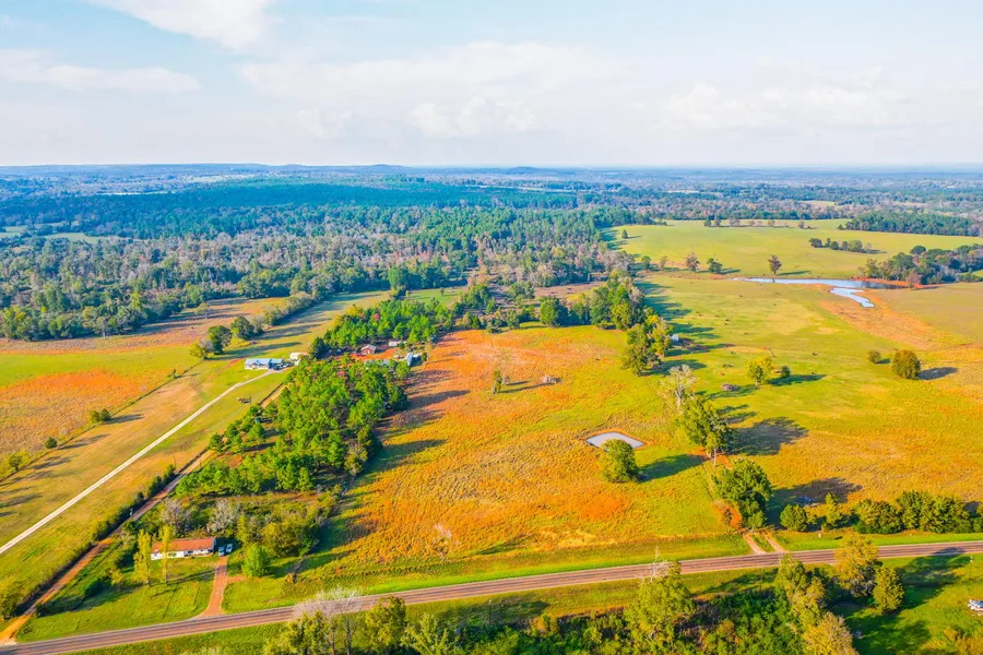
This property is irregular in shape with approximately 540 feet of frontage along the northern boundary of SH 21. The southern portion of the tract is open, the central portion is a mixture of thinned timber, mixed mature timber and some areas that are being converted to open areas. The rear 20 25 acres has basically been clear-cut in recent years and currently consists of regrowth. This area has a good drainage with a spring shown on the topo map that drains into a lake on the property to the east of this tract. It appears that there is a good lake site in this area that could be explored. There is a stock pond in the southern pasture and a spring / drainage in the central portion as well. Elevation on the tract ranges from an approximate low of 360 ASL to an approximate high of 430 ASL. The tract is located approximately 2.9 miles east of the SH 69 / SH 21 intersection in Alto. Coordinates to the gate at the SE corner of the property are: 31.6583, -95.0255. There is a gate along the frontage, but access is easier coming in from one of the adjoining parcels as this is a portion of a larger parent tract. Call today for your private tour.
- Fantastic mixed-use potential
- Rolling topography with a good mixture of pasture and mixed timber
- Located within Alto ISD
- Long frontage along SH 21
- Ag Exemption in place
- All boundary lines on map exhibits are approximate and should be verified by buyer
The information contained herein is deemed reliable but is not warranted or guaranteed by the Broker or Seller. The Broker (Whitetail Properties) does not assume liability for typographical errors, misprints, nor for misinformation that may have been given to us. All property is subject to change, withdrawal, or prior sale. Buyers' agents must be identified on the first contact with the Broker and must accompany the buyer on showings to receive full fee participation.
From elevation to risk assessment
Search for detailed parcel information including; Elevation & Vegetation Maps, Ownership Information, Detailed Parcel Information, Crop History Map, Soil Survey Productivity Data, and more.
Research Parcel InformationDirections
Call for details.
Environmental Factors
Land for Sale by Cody Robertson
Cherokee County Properties By Type
- Ranches for Sale in Cherokee County, Texas
- Recreational Property for Sale in Cherokee County, Texas
- Undeveloped Land for Sale in Cherokee County, Texas
- Farms for Sale in Cherokee County, Texas
- Lakefront Property for Sale in Cherokee County, Texas
- Hunting Land for Sale in Cherokee County, Texas
- Residential Property for Sale in Cherokee County, Texas
- Timberland for Sale in Cherokee County, Texas
- Commercial Property for Sale in Cherokee County, Texas
- Riverfront Property for Sale in Cherokee County, Texas
- Horse Property for Sale in Cherokee County, Texas
- Beachfront Property for Sale in Cherokee County, Texas
Properties for Sale Nearby Counties
Cherokee County Properties By City
- Alto, Texas Land for Sale
- Cuney, Texas Land for Sale
- Gallatin, Texas Land for Sale
- Jacksonville, Texas Land for Sale
- Maydelle, Texas Land for Sale
- New Summerfield, Texas Land for Sale
- Reklaw, Texas Land for Sale
- Rusk, Texas Land for Sale
- Wells, Texas Land for Sale
- Dialville, Texas Land for Sale
- Forest, Texas Land for Sale
- Henrys Chapel, Texas Land for Sale
- More
- Pierces Chapel, Texas Land for Sale
- Pine Hill, Texas Land for Sale
- Redlawn, Texas Land for Sale
- Reese, Texas Land for Sale
- Tecula, Texas Land for Sale
- Turney, Texas Land for Sale
- Atoy, Texas Land for Sale
- Brunswick, Texas Land for Sale
- Bulah, Texas Land for Sale
- Central High, Texas Land for Sale
- Circle, Texas Land for Sale
- Cove Springs, Texas Land for Sale
- Craft, Texas Land for Sale
- Delmer, Texas Land for Sale
- Emmaus, Texas Land for Sale
- Gould, Texas Land for Sale
- Hudson Chapel, Texas Land for Sale
- Hume, Texas Land for Sale
- Ironton, Texas Land for Sale
- Java, Texas Land for Sale
- Lake View, Texas Land for Sale
- Larissa, Texas Land for Sale
- Mewshaw, Texas Land for Sale
- Mittie, Texas Land for Sale
- Morrill, Texas Land for Sale
- Mountain Heaven, Texas Land for Sale
- Pomona, Texas Land for Sale
- Ponta, Texas Land for Sale
- Prices, Texas Land for Sale
- Stryker Creek Junction, Texas Land for Sale
- Sweet Union, Texas Land for Sale
- Weeping Mary, Texas Land for Sale
- Wild Hurst, Texas Land for Sale