The Hebron Farm
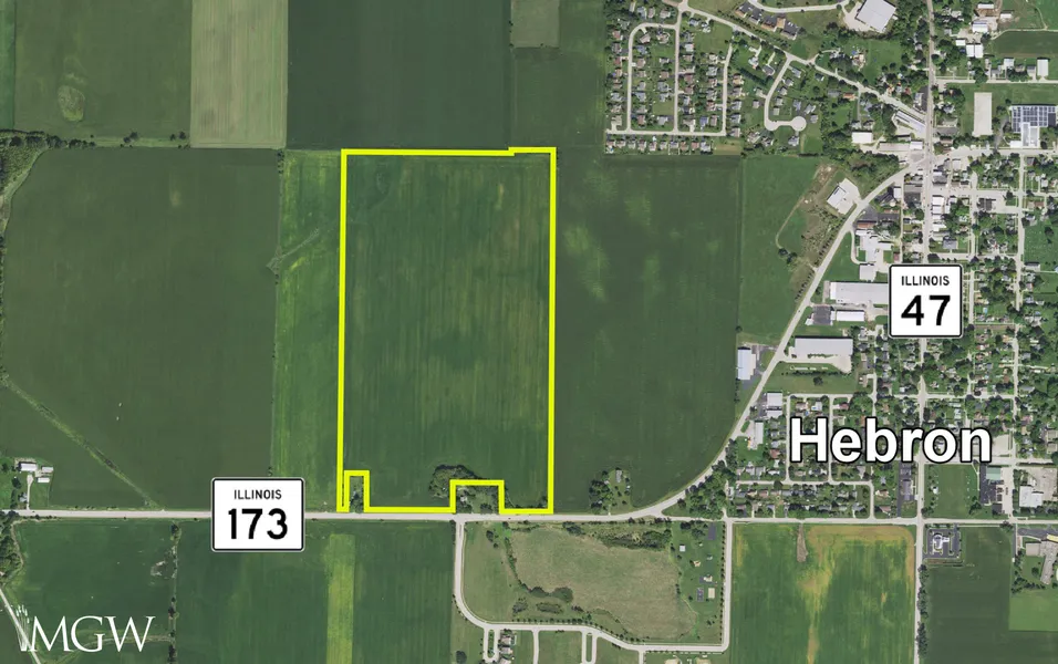
Location: The subject farm is located approximately 43 miles northwest of Chicago O'Hare International Airport and is within the village of Hebron. Nearby cities include: Richmond (6 miles east), Woodstock (7 3/8 miles south), and Harvard (7 5/8 miles southwest).
Frontage: There is approximately 3/16 mile of road frontage on Illinois Route 173.
Major Highways: Illinois Route 173 is the south border of the property, Illinois Route 47 is 1/2 mile east, and U.S. Route 14 is 7 3/4 miles west of the property.
Legal Description: A brief legal description indicates the Hebron Farm is located in Part of the Northwest Quarter of Section 17, Township 46 North Range 7 East (Hebron Township), McHenry County, Illinois.
Total Acres: There are a total of 85.21 acres, more or less, according to the McHenry County Assessor.
Tillable Acres: There are approximately 82.05 tillable acres according to the McHenry County FSA.
Soil Types: Proctor silt loam is the primary soil type found on this farm.
Topography: The topography of the subject farm is level to nearly level.
Mineral Rights: All mineral rights owned by the seller will be transferred in their entirety to the new owner.
Possession: Possession will be given at closing, subject to the terms and conditions set forth in a purchase contract.
Price Terms: The asking price is $13,950 per acre. A 10% earnest money deposit should accompany any offer to purchase.
Financing: Mortgage financing is available from several sources. Names and addresses will be provided upon request.
Taxes: The 2022 real estate taxes totaled $3,450.02. The tax parcel numbers are: #03-17-100-012 & #03-17-100-016.
Grain Markets: There are a number of grain markets located within 15 miles of The Hebron Farm.
Zoning: The property is zoned E-1, Estate District.
From elevation to risk assessment
Search for detailed parcel information including; Elevation & Vegetation Maps, Ownership Information, Detailed Parcel Information, Crop History Map, Soil Survey Productivity Data, and more.
Research Parcel InformationDirections
The farm's GPS coordinates are 42.464993, -88.446591, and can be copied and pasted into a mapping application for directions.
Environmental Factors
Resources
Land for Sale by Mark Mommsen
McHenry County Properties By Type
- Farms for Sale in McHenry County, Illinois
- Residential Property for Sale in McHenry County, Illinois
- Undeveloped Land for Sale in McHenry County, Illinois
- Ranches for Sale in McHenry County, Illinois
- Lakefront Property for Sale in McHenry County, Illinois
- Recreational Property for Sale in McHenry County, Illinois
- Horse Property for Sale in McHenry County, Illinois
- Timberland for Sale in McHenry County, Illinois
- Hunting Land for Sale in McHenry County, Illinois
- Riverfront Property for Sale in McHenry County, Illinois
- Commercial Property for Sale in McHenry County, Illinois
- Beachfront Property for Sale in McHenry County, Illinois
Properties for Sale Nearby Counties
McHenry County Properties By City
- Alden, Illinois Land for Sale
- Algonquin, Illinois Land for Sale
- Cary, Illinois Land for Sale
- Crystal Lake, Illinois Land for Sale
- Fox River Grove, Illinois Land for Sale
- Harvard, Illinois Land for Sale
- Hebron, Illinois Land for Sale
- Huntley, Illinois Land for Sale
- Lake In The Hills, Illinois Land for Sale
- Lakewood, Illinois Land for Sale
- Marengo, Illinois Land for Sale
- Mchenry, Illinois Land for Sale
- More
- Richmond, Illinois Land for Sale
- Ringwood, Illinois Land for Sale
- Spring Grove, Illinois Land for Sale
- Union, Illinois Land for Sale
- Wonder Lake, Illinois Land for Sale
- Woodstock, Illinois Land for Sale
- Barrington Hills, Illinois Land for Sale
- Bull Valley, Illinois Land for Sale
- Chemung, Illinois Land for Sale
- Coral, Illinois Land for Sale
- Holiday Hills, Illinois Land for Sale
- Johnsburg, Illinois Land for Sale
- Lakemoor, Illinois Land for Sale
- Lawrence, Illinois Land for Sale
- Mccullom Lake, Illinois Land for Sale
- Oakwood Hills, Illinois Land for Sale
- Prairie Grove, Illinois Land for Sale
- Ridgefield, Illinois Land for Sale
- Solon Mills, Illinois Land for Sale
- Trout Valley, Illinois Land for Sale
- Barreville, Illinois Land for Sale
- Belden, Illinois Land for Sale
- Big Foot Prairie, Illinois Land for Sale
- Burtons Bridge, Illinois Land for Sale
- Camp Algonquin, Illinois Land for Sale
- Colby Point, Illinois Land for Sale
- Coyne, Illinois Land for Sale
- Crystal Gardens, Illinois Land for Sale
- Crystal Manor, Illinois Land for Sale
- Crystal Vista, Illinois Land for Sale
- Eastwood Manor, Illinois Land for Sale
- Emerald Park, Illinois Land for Sale
- Ferndale, Illinois Land for Sale
- Fox River Shores, Illinois Land for Sale
- Franklinville, Illinois Land for Sale
- Haegers Bend, Illinois Land for Sale
- Hartland, Illinois Land for Sale
- Holcombville Corners, Illinois Land for Sale
- Indian Trails, Illinois Land for Sale
- Lilymoor, Illinois Land for Sale
- McHenry Shores, Illinois Land for Sale
- North Shore, Illinois Land for Sale
- Pistakee, Illinois Land for Sale
- Pistakee Highlands, Illinois Land for Sale
- Rawson Bridge, Illinois Land for Sale
- Riley, Illinois Land for Sale
- Riverstream, Illinois Land for Sale
- Silver Lake, Illinois Land for Sale
- Ski Hill, Illinois Land for Sale
- Sunrise Ridge, Illinois Land for Sale
- Terra Cotta, Illinois Land for Sale
- Turner Camp, Illinois Land for Sale
- Wonder Center, Illinois Land for Sale