860 Blue Mountain Trail, Fort Davis, TX 79734 - Jeff Davis County
Blue Mountain Vista
Description
Location
Blue Mountain Vista is a 74-acre mountaintop property located along the scenic foothills of Blue Mountain in Jeff Davis County, Texas, just outside Fort Davis. The property sits within the heart of the Davis Mountains, offering elevated privacy, cool summer temperatures, and sweeping views of surrounding peaks, including Mount Livermore, the Puertacitas and Haystack Mountains. A 1-mile community road leads to the front gate from State Hwy 166.
Overview
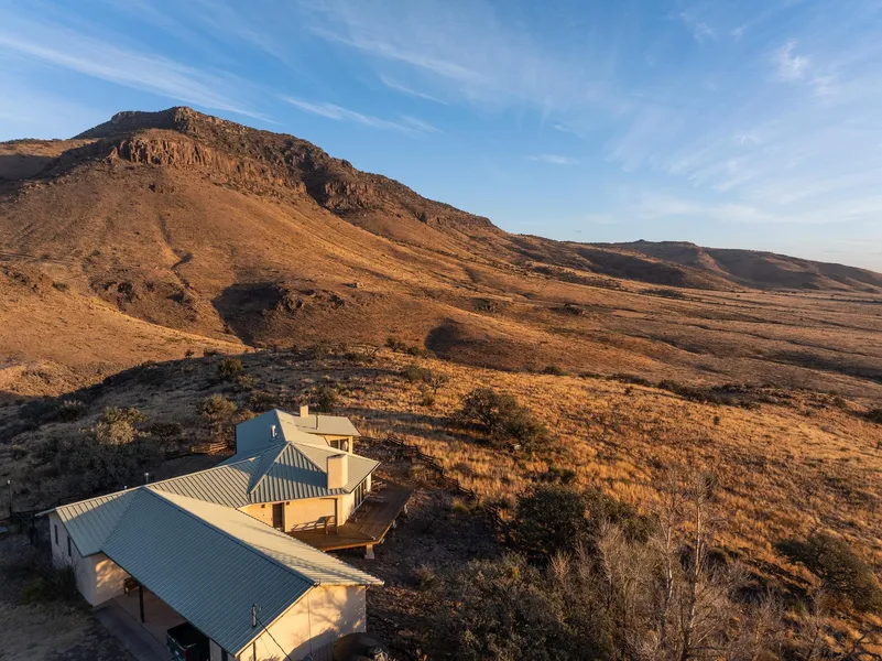
Set atop a gently sloping mesa, the property is characterized by expansive mountain views, rolling grasslands, and mature woodland. The elevated homesite provides exceptional privacy and uninterrupted vistas in multiple directions, making it ideal for a mountain retreat or full-time residence. The combination of acreage, elevation, and proximity to Fort Davis and Marfa makes this one of the most unique small-acreage offerings in the region.
Improvements
The property is improved with a custom-built, handcrafted 2-bedroom, 2 bath residence constructed by Rainbow Adobe Builders. The home features pier-and-beam construction with a stucco exterior, vaulted tongue-and-groove ceilings, exposed peeled pine beams, kiva fireplaces, and large windows framing dramatic mountain views. A gourmet kitchen, spacious living areas, surrounding deck, 3-bay carport, storage building, paved driveway, and electronic gate complete the improvements. A well and garage are located down the hill near the entrance.
Habitat and Wildlife
The land supports classic high-elevation Davis Mountains habitat, including native grasses such as blue gramma and sideoats gramma, along with Emory oak, gray oak, alligator juniper, and pion pine. Wildlife is abundant and includes mule deer, whitetail, aoudad, javelina, fox, Montezuma quail, and a wide variety of migratory and resident bird species. The setting is well suited for hiking, photography, birding, and quiet enjoyment of the surrounding landscape.
From elevation to risk assessment
Search for detailed parcel information including; Elevation & Vegetation Maps, Ownership Information, Detailed Parcel Information, Crop History Map, Soil Survey Productivity Data, and more.
Research Parcel InformationDirections
1-mile community road leads to the front gate from State Hwy 166.
Resources
Jeff Davis County Properties By Type
- Ranches for Sale in Jeff Davis County, Texas
- Undeveloped Land for Sale in Jeff Davis County, Texas
- Hunting Land for Sale in Jeff Davis County, Texas
- Residential Property for Sale in Jeff Davis County, Texas
- Farms for Sale in Jeff Davis County, Texas
- Recreational Property for Sale in Jeff Davis County, Texas
- Horse Property for Sale in Jeff Davis County, Texas
- Commercial Property for Sale in Jeff Davis County, Texas
- Timberland for Sale in Jeff Davis County, Texas
- Lakefront Property for Sale in Jeff Davis County, Texas
- Beachfront Property for Sale in Jeff Davis County, Texas
- Riverfront Property for Sale in Jeff Davis County, Texas