MURPHY RD VANSANT, VA 24656, Vansant, VA 24656 - Dickenson County
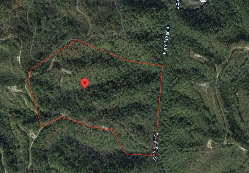
87.796 Acres for Sale in Dickenson County Virginia - Dramatic discount!
87.796 Acres for Sale in Dickenson County Virginia - Dramatic discount!
Priced far below all comps!
Call or Text us today!!- 541-375-0012
There may be the opportunity to owner finance this property in the future, but for now, we are only accepting cash offers or offers where buyer provides their own financing- if you want to move forward, call or text 541-375-0012 and we can send you a contract to look over and sign!
Link To Google Map Directions
County GIS Website Link
Address: MURPHY RD VANSANT, VA 24656
Cash Discount Price: $29,900.00
County: Dickenson
Acres: 87.796 Acres (Raw Land)
Coordinates: 37.151649, -82.208818
Parcel #: 7329
Tax account #: 5791
Yearly Taxes: $179.02
Legal Description: Beginning on a poplar and beech in the Lynn Hollow, a corner to Albert Hackney and Harden Owen's land; and with a reversed line of the latter S 85 E 20 poles to a sassafras, poplar and beech in said hollow; thence east 25 poles to white oak at a fork of Ferrel's Branch; thence down said branch with a line of Reen Owens, Jr.: N 30 E 95 poles to a spruce pine and beech at another fork of said branch; thence leaving said lines and with Andrew Owens land; N 77 W 30 poles to a buckeye and beech; N 56 30 W 28 poles to a black gum and wahoo; N 67 30 W 61 poles to a white oak on the ridge; S 56 W 72 poles to a chestnut oak on said ridge; thence leaving the said Owens lines S 30 W 18 poles to a black jack on a knob, a corner to Mary J. Hackney's land; thence with her land lines S 23 E 48 poles to a double chestnut oak on a spur, a corner to Albert Hackney land; thence with his Lines reversed, N 60 E 20 poles to a black and chestnut oak; S 72 E 46 poles to a white and red oak; S 85 E 22 poles to a black jack on top of a little spur; thence down said spur S 29 E 38 poles to the Beginning, containing about 104 acres, more or less:
Less and except the coal and mineral and other rights heretofore sold and conveyed by deeds of record.
It being the same property conveyed to Adina C. Krum, Trustee of the Adina C. Krum Life Trust Agreement dated April 24, 1998 by Deed from Charles L. Krum, JR, (being one and the same person as Charles L. Krum) and Adina C. Krum, husband and wife dated June 30, 1998, recorded June 30, 1998 in the Clerk's Office of the Circuit Court of Dickenson County, Virginia in Deed Book 336, Page 557.
Zoning: No Zoning
Elevation: 1600 ft.
Special ad notes: This property has gas company roads going to it, but gates are accross the roads and no one will give us the key. The property is landlocked and does not have an easement to it. No owner financing available on this property, cash only.
The photos in this ad were taken near the property, but may not be of the actual property.
From elevation to risk assessment
Search for detailed parcel information including; Elevation & Vegetation Maps, Ownership Information, Detailed Parcel Information, Crop History Map, Soil Survey Productivity Data, and more.
Research Parcel InformationDirections
Bee
Virginia 24217, USA
Head southeast on VA-80 E toward Naugatuck Rd
0.9 mi
Turn left onto State Rte 605
0.4 mi
Turn right onto Ooc
0.3 mi
Resources
Land for Sale by Luke Harris
Dickenson County Properties By Type
- Farms for Sale in Dickenson County, Virginia
- Residential Property for Sale in Dickenson County, Virginia
- Lakefront Property for Sale in Dickenson County, Virginia
- Undeveloped Land for Sale in Dickenson County, Virginia
- Hunting Land for Sale in Dickenson County, Virginia
- Recreational Property for Sale in Dickenson County, Virginia
- Timberland for Sale in Dickenson County, Virginia
- Commercial Property for Sale in Dickenson County, Virginia
- Horse Property for Sale in Dickenson County, Virginia
- Ranches for Sale in Dickenson County, Virginia
- Beachfront Property for Sale in Dickenson County, Virginia
- Riverfront Property for Sale in Dickenson County, Virginia
Properties for Sale Nearby Counties
Dickenson County Properties By City
- Bee, Virginia Land for Sale
- Birchleaf, Virginia Land for Sale
- Breaks, Virginia Land for Sale
- Clinchco, Virginia Land for Sale
- Clintwood, Virginia Land for Sale
- Haysi, Virginia Land for Sale
- Nora, Virginia Land for Sale
- Mcclure, Virginia Land for Sale
- Aily, Virginia Land for Sale
- Baden, Virginia Land for Sale
- Bartlick, Virginia Land for Sale
- Blowing Rock, Virginia Land for Sale
- More
- Bucu, Virginia Land for Sale
- Carrie, Virginia Land for Sale
- Colley, Virginia Land for Sale
- Darwin, Virginia Land for Sale
- Delano, Virginia Land for Sale
- Duty, Virginia Land for Sale
- Dwale, Virginia Land for Sale
- Flat Top, Virginia Land for Sale
- Flemingtown, Virginia Land for Sale
- Foraker, Virginia Land for Sale
- Freeling, Virginia Land for Sale
- Fremont, Virginia Land for Sale
- Georges Fork, Virginia Land for Sale
- Herald, Virginia Land for Sale
- Isom, Virginia Land for Sale
- Leck, Virginia Land for Sale
- Lockhart Flats, Virginia Land for Sale
- Longfork, Virginia Land for Sale
- Mart, Virginia Land for Sale
- Millard, Virginia Land for Sale
- Nancy, Virginia Land for Sale
- Nealy Ridge, Virginia Land for Sale
- Norland, Virginia Land for Sale
- Omaha, Virginia Land for Sale
- Open Fork, Virginia Land for Sale
- Ramsey Flats, Virginia Land for Sale
- Skeetrock, Virginia Land for Sale
- Smith Corners, Virginia Land for Sale
- Steinman, Virginia Land for Sale
- Stratton, Virginia Land for Sale
- Tandy, Virginia Land for Sale
- Tarpon, Virginia Land for Sale
- Tenso, Virginia Land for Sale
- Tiny, Virginia Land for Sale
- Tivis, Virginia Land for Sale
- Viers, Virginia Land for Sale
- Wakenva, Virginia Land for Sale
- West Dante, Virginia Land for Sale