Auction Information
925 acres in Lawrence County, Tennessee
Description
I bet Davy Crockett traveled this farm and Creek heading to Alabama!!! His State Park is just north of this tract on Shoals Creek. Lot's of history here!
ABSOLUTE ESTATE AUCTION
Saturday August 10 at 10am
( under the tent live or online bidding)
The Rochester Estate
926 acres in 8 tracts & as a whole
Barnett Dr. Leoma Tenn 38468
Tax map No; 107 Parcel 001.00 (129 acres)
Tax map No: 106 Parcel 010.00 (795 acres)
Deed Book RB58 Page 734
Get your 4 wheeler, side by side Ranger, 4 wheel drive ATV & Vehicle and tour and inspect Field/logging/hunting roads/ trails opened ! A must see!
Marketable Timber, Development Potential, Beautiful Clean Streams of Water flowing through these Tennessee Hills & Hollows!
850 acres +/- acres Big Marketable TIMBER
90+/- acres of open land
1&1/2 miles of asphalt road frontage
Leoma Public Water
Homesites
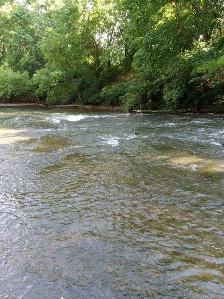
Over 1 mile of Shoals Creek shores
Callahan & Whitehouse Branches
Scenic Tenn. Hills & Hollows
Trophy Hunting
Bid live ( NO BUYERS PREMIUM) on site under the tent or Online (5% Buyer's Premium )(NOTE: Bidders bidding on line will be required to produce a letter of credit from a bank stating the amount they are qualified to bid) ,Free NO Obligation Pre-registration open
A 1% referral fee will be paid to the Firm that produces a bidder that buys and closing. Simply have your buyer sign your firm's Agency Disclosure stating that you represent them in the bidding and buying of this Real Estate.
Survey Cost split 50/50 between Buyers and Sellers. Buyers pay their closing costs, Sellers pay their closing cost.
Bidding order; Offered by the acre, Bidders Choice. The winning bidder in each round of bidding will have the choice of choosing any tract or group or as a whole. When a Bidder is recognized by the auctioneer as the winning bidder, then the tracts they choose become theirs and will not be regrouped. The final Purchase price will be determined by multiplying the final bids times the total acres in the chosen tracts, plus survey costs.
From elevation to risk assessment
Search for detailed parcel information including; Elevation & Vegetation Maps, Ownership Information, Detailed Parcel Information, Crop History Map, Soil Survey Productivity Data, and more.
Research Parcel InformationEnvironmental Factors
Lawrence County Properties By Type
- Farms for Sale in Lawrence County, Tennessee
- Residential Property for Sale in Lawrence County, Tennessee
- Undeveloped Land for Sale in Lawrence County, Tennessee
- Ranches for Sale in Lawrence County, Tennessee
- Riverfront Property for Sale in Lawrence County, Tennessee
- Hunting Land for Sale in Lawrence County, Tennessee
- Recreational Property for Sale in Lawrence County, Tennessee
- Horse Property for Sale in Lawrence County, Tennessee
- Lakefront Property for Sale in Lawrence County, Tennessee
- Timberland for Sale in Lawrence County, Tennessee
- Commercial Property for Sale in Lawrence County, Tennessee
- Beachfront Property for Sale in Lawrence County, Tennessee
Properties for Sale Nearby Counties
Lawrence County Properties By City
- Ethridge, Tennessee Land for Sale
- Five Points, Tennessee Land for Sale
- Iron City, Tennessee Land for Sale
- Lawrenceburg, Tennessee Land for Sale
- Leoma, Tennessee Land for Sale
- Loretto, Tennessee Land for Sale
- Saint Joseph, Tennessee Land for Sale
- Summertown, Tennessee Land for Sale
- Westpoint, Tennessee Land for Sale
- Alexander Springs, Tennessee Land for Sale
- Appleton, Tennessee Land for Sale
- Barnesville, Tennessee Land for Sale
- More
- Bird Mill, Tennessee Land for Sale
- Bonnertown, Tennessee Land for Sale
- Brace, Tennessee Land for Sale
- Brier Hill, Tennessee Land for Sale
- Brown Crossroads, Tennessee Land for Sale
- Busby, Tennessee Land for Sale
- Center, Tennessee Land for Sale
- Chinubee, Tennessee Land for Sale
- Clack Branch, Tennessee Land for Sale
- Clearview Heights, Tennessee Land for Sale
- Crestview, Tennessee Land for Sale
- Crewstown, Tennessee Land for Sale
- Dunn, Tennessee Land for Sale
- Fall River, Tennessee Land for Sale
- Gaitherville, Tennessee Land for Sale
- Gandy, Tennessee Land for Sale
- Henryville, Tennessee Land for Sale
- Hood Lake, Tennessee Land for Sale
- Hudson, Tennessee Land for Sale
- Idaho, Tennessee Land for Sale
- Knob Creek, Tennessee Land for Sale
- Liberty Grove, Tennessee Land for Sale
- Lodi, Tennessee Land for Sale
- Lower Mockeson, Tennessee Land for Sale
- New Prospect, Tennessee Land for Sale
- Ovilla, Tennessee Land for Sale
- Park Grove, Tennessee Land for Sale
- Peppertown, Tennessee Land for Sale
- Pinkney, Tennessee Land for Sale
- Pleasant Point, Tennessee Land for Sale
- Quercus, Tennessee Land for Sale
- Ramah, Tennessee Land for Sale
- Rascal Town, Tennessee Land for Sale
- Revilo, Tennessee Land for Sale
- Rossboro, Tennessee Land for Sale
- Saint Truitt, Tennessee Land for Sale
- Sims Ridge, Tennessee Land for Sale
- Springers Station, Tennessee Land for Sale
- Turkey Track, Tennessee Land for Sale
- Upper Mockeson, Tennessee Land for Sale
- Wayland Springs, Tennessee Land for Sale
- Webber City, Tennessee Land for Sale