31622 Munn Rd, Unity, OR 97884 - Baker County
Unity Oregon Cattle Ranch
SALE PENDING!! 31622 Munn Road & 31249 Munn Road, Unity, Oregon 97884.
There are three tax lots in this ranch property: Tax lot 1100, T12S, R36 EWM
390 acres; tax lot 2600, T12S, R37 EWM-434.51 acres; and tax lot 500, T12S, R37
EWM, section 19 163.11 acres. Tax lot 1400, T12S, R36 EWM 35 acres is
Whited Reservoir, with four owners. This is a total of 987.62 deeded acres, plus
a 7% interest in Whited Reservoir, which encompasses 35 acres. The ranch
headquarters are located about five miles west of Unity, and in close proximity
to Unity Reservoir. There is a county road from the John Day highway which is
about one mile long. John Day, OR is about 45 miles to the west, Vale, OR to
the southeast and Baker City, OR to the northeast are each about one hour
away. Boise, Idaho to the southeast is approximately 2 1/2 hours away.
This ranch has 987.62 acres of deeded land in three tax lots
plus a percentage interest in a 35 acre tax lot which includes Whited Reservoir.
This reservoir is used to irrigate a portion of the ranch. Except for the reservoir,
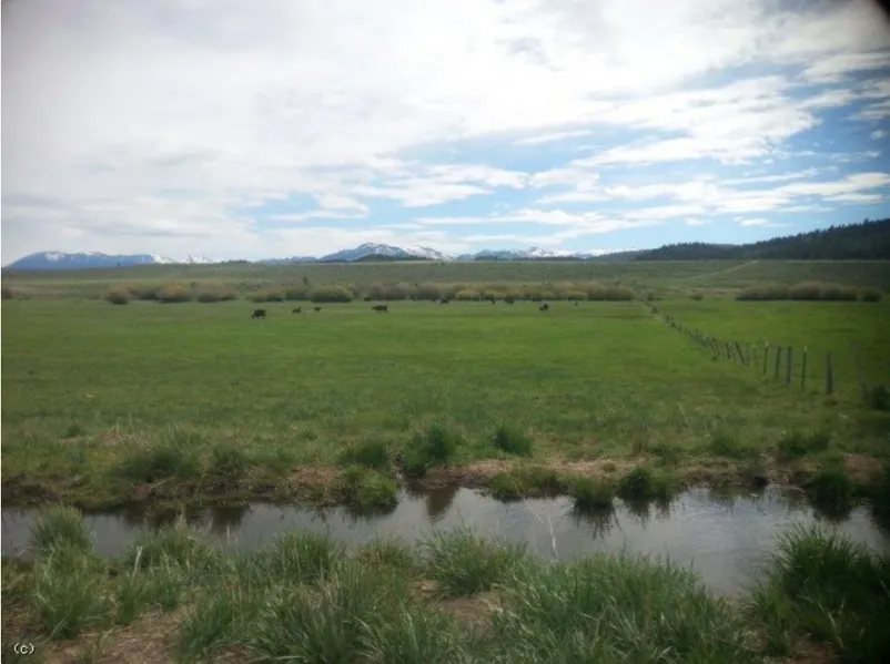
this property is all contiguous. The land is mostly level meadows, with some
small hills and some bigger ridges. The land joins the Wallowa-Whitman National
Forest to the north. There are approximately 40 acres that has some
timber on it. The meadow land is high quality soil, and the meadows produced
322 tons of hay in 2017, plus pasturing a large portion of the irrigated ground.
The meadows seem to consistently produce an average of 1.5 tons per acre.
The owners have not been fertilizing the meadows. The Middle Fork of Burnt
River runs through the northern portion of this ranch, providing irrigation
water and stock water. The rest of the irrigation comes from the South Fork of
Burnt River, but is stored in Whited Reservoir and then delivered to the ranch.
There is one main set of improvements and
another homesite area that used to have a home on it. The main headquarters
has a 1986 double wide manufactured home, 1056 sq. ft. , two bedroom, two
full baths, with an office, family room addition, and mudroom. Heating has
three sources: forced air furnace, wood stove, and oil heater. In addition to the
home, there is a 24 ft by 52 ft shop which is enclosed with a cement floor. The
barn is 1280 sq. ft., and there is a pump house and gas shed. There is a set of
working corrals with scales. Drinking water is furnished by a spring and there
is also a domestic well. The other homesite area originally had a home on it.
There is still a shop, which is 1125 sq. ft., and has a dirt floor, and some corrals,
with an older septic system.
This ranch has approximately 445.1 acres of primary water
rights. These numbers come from the Burnt River Irrigation District, which
monitors and distributes the water according to acres and priority. Water
comes from the Middle Fork and South Fork of Burnt River, and is regulated by
the District. This fee for the District is $1,087.96 per year. The north end of the
ranch is irrigated by the Middle Fork of Burnt River and there is a private reservoir,
about 20 acres in size, which helps with later water. The main River water
usually lasts till middle June to July 1st. The south part is irrigated from the
South Fork of Burnt River, and is stored and delivered from Whited Reservoir.
This water normally lasts until October 1. All is flood irrigated.
987.62 DEEDED ACRES
THREE TAX LOTS
445.1 +/- ACRES WATER RIGHTS FOR NATIVE MEADOW
HOME, BARN, 2 SHOPS, CORRALS
191 HEAD FOREST PERMIT, 2 HEAD BLM
PRIVATE RESERVOIR
SOME TIMBER
NEAR UNITY RESERVOIR
SCENIC AREA
From elevation to risk assessment
Search for detailed parcel information including; Elevation & Vegetation Maps, Ownership Information, Detailed Parcel Information, Crop History Map, Soil Survey Productivity Data, and more.
Research Parcel InformationResources
More Land for Sale in Baker County
Baker County Properties By Type
- Ranches for Sale in Baker County, Oregon
- Undeveloped Land for Sale in Baker County, Oregon
- Farms for Sale in Baker County, Oregon
- Residential Property for Sale in Baker County, Oregon
- Hunting Land for Sale in Baker County, Oregon
- Riverfront Property for Sale in Baker County, Oregon
- Commercial Property for Sale in Baker County, Oregon
- Lakefront Property for Sale in Baker County, Oregon
- Timberland for Sale in Baker County, Oregon
- Recreational Property for Sale in Baker County, Oregon
- Horse Property for Sale in Baker County, Oregon
- Beachfront Property for Sale in Baker County, Oregon
Properties for Sale Nearby Counties
Baker County Properties By City
- Baker City, Oregon Land for Sale
- Bridgeport, Oregon Land for Sale
- Durkee, Oregon Land for Sale
- Haines, Oregon Land for Sale
- Halfway, Oregon Land for Sale
- Hereford, Oregon Land for Sale
- Huntington, Oregon Land for Sale
- Oxbow, Oregon Land for Sale
- Richland, Oregon Land for Sale
- Sumpter, Oregon Land for Sale
- Unity, Oregon Land for Sale
- Granite, Oregon Land for Sale
- More
- Keating, Oregon Land for Sale
- Lime, Oregon Land for Sale
- Medical Springs, Oregon Land for Sale
- Rye Valley, Oregon Land for Sale
- Bourne, Oregon Land for Sale
- Brownlee, Oregon Land for Sale
- Carson, Oregon Land for Sale
- China Town, Oregon Land for Sale
- Clarksville, Oregon Land for Sale
- Cornucopia, Oregon Land for Sale
- Encina, Oregon Land for Sale
- Greenhorn, Oregon Land for Sale
- Hutchinson, Oregon Land for Sale
- Jimtown, Oregon Land for Sale
- Little Alps, Oregon Land for Sale
- McEwen, Oregon Land for Sale
- New Bridge, Oregon Land for Sale
- Pine, Oregon Land for Sale
- Pine Creek, Oregon Land for Sale
- Pondosa, Oregon Land for Sale
- Robinette, Oregon Land for Sale
- Sparta, Oregon Land for Sale
- Weatherby, Oregon Land for Sale
- Wingville, Oregon Land for Sale