40 ACRES, NO NEIGHBORS & NO RESTRICTIONS IN NORTHERN ARIZONA
This 40-acre property in Northern Arizona has beautiful views, great access and no restrictions.
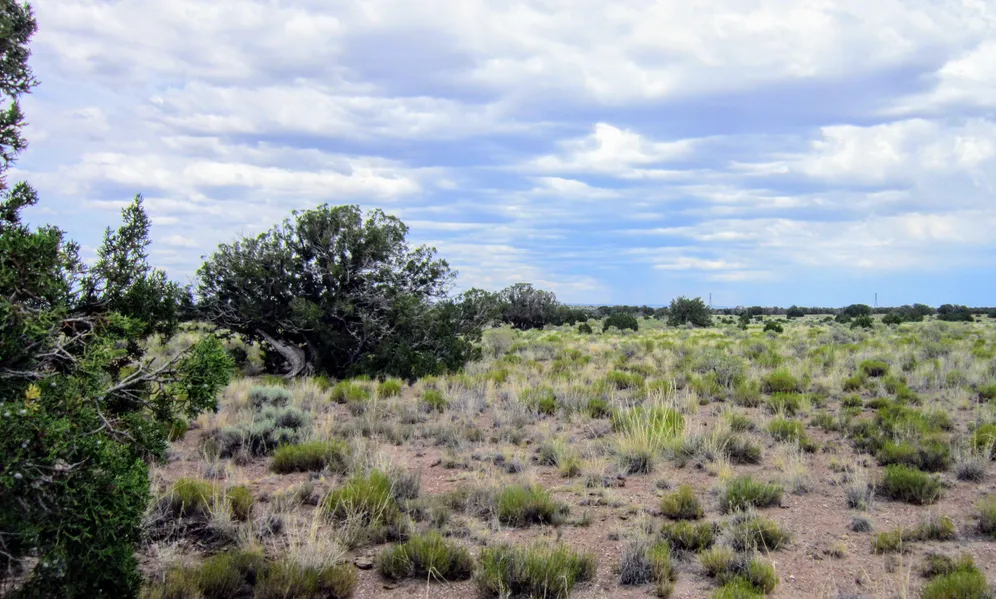
The following paragraph is from our photographer:
Property is accessed via a well-made two track off of well-made County Road 6110. The two track runs along the west and northern border. Property is mostly flat with a slight southern slope and the far north side of the lot is flat. There are sporadic Juniper trees but mostly grass, sagebrush and other low vegetation. Great views in all directions. Best views of the White Mountains are to the south and southwest but northwest gives the furthest views. No neighbors, 4G cell service available.
Close to St Johns, you can spend the day enjoying the beauty that surrounds you with the convenience of a quick drive for eats or pick up the basics. With no neighbors and no restrictions, its the perfect place to get off the grid and live how you want.
I have included ACTUAL property photos. I have not visited this property and have included everything I know about it below.
WHATS CLOSE?
8 miles to Gas, Groceries & Post Office in St Johns
9 miles to Dollar General in St Johns
20 miles to Lyman Lake State Park
1.5 hours to Petrified Forest National Park and Painted Desert
2.5 hours to Flagstaff
3.5 hours to Sedona and Albuquerque
4 hours to Phoenix
DISCOUNTED CASH PRICE $14,997 plus $299 Documentation Fee
MONTHLY INSTALLMENT PRICING OPTION Available - Visit Website for Details
PROPERTY DETAILS
Size (Acres): 40.00
General Location: N6110, St Johns, AZ 85936
APN or Other ID: 20366005
Subdivision: N/A
Legal Description: The Southeast 1/4 of the Northeast 1/4 of Section 29, Township 13 North, Range 29 East of the Gila and Salt River Base and Meridian, Apache County, Arizona, aka Parcel No. 140
Approx. GPS:
34.508530, -109.283279
34.508538, -109.278892
34.504876, -109.278814
34.504878, -109.283205
Property Type: Rural Land
Zoning: General Agricultural
HOA/POA Fees: No
Terrain: Varied
General Elevation: Approx. 6,150
Power: Would be by generator, solar or wind
Phone: Mobile/Satellite/Alternative
Water: Would need to drill well or use alternative system
Sewer: Would need septic or alternative system
Roads: Dirt
Time to Build: No Limit
Title Info: Clear Title, Conveyed from LG Solutions LLC
Annual Property Taxes: Approx. $86
Doc Fee: $299
From elevation to risk assessment
Search for detailed parcel information including; Elevation & Vegetation Maps, Ownership Information, Detailed Parcel Information, Crop History Map, Soil Survey Productivity Data, and more.
Research Parcel InformationEnvironmental Factors
Land for Sale by Dave Ayres
Apache County Properties By Type
- Undeveloped Land for Sale in Apache County, Arizona
- Farms for Sale in Apache County, Arizona
- Residential Property for Sale in Apache County, Arizona
- Ranches for Sale in Apache County, Arizona
- Recreational Property for Sale in Apache County, Arizona
- Lakefront Property for Sale in Apache County, Arizona
- Riverfront Property for Sale in Apache County, Arizona
- Beachfront Property for Sale in Apache County, Arizona
- Hunting Land for Sale in Apache County, Arizona
- Timberland for Sale in Apache County, Arizona
- Commercial Property for Sale in Apache County, Arizona
- Horse Property for Sale in Apache County, Arizona
Properties for Sale Nearby Counties
- Catron County, Arizona Land for Sale
- Cibola County, Arizona Land for Sale
- Graham County, Arizona Land for Sale
- Greenlee County, Arizona Land for Sale
- McKinley County, Arizona Land for Sale
- Montezuma County, Arizona Land for Sale
- Navajo County, Arizona Land for Sale
- San Juan County, Arizona Land for Sale
- San Juan County, Arizona Land for Sale
Apache County Properties By City
- Alpine, Arizona Land for Sale
- Chambers, Arizona Land for Sale
- Chinle, Arizona Land for Sale
- Concho, Arizona Land for Sale
- Dennehotso, Arizona Land for Sale
- Eagar, Arizona Land for Sale
- Fort Defiance, Arizona Land for Sale
- Ganado, Arizona Land for Sale
- Greer, Arizona Land for Sale
- Houck, Arizona Land for Sale
- Lukachukai, Arizona Land for Sale
- Lupton, Arizona Land for Sale
- More
- Many Farms, Arizona Land for Sale
- Mcnary, Arizona Land for Sale
- Nazlini, Arizona Land for Sale
- Nutrioso, Arizona Land for Sale
- Rock Point, Arizona Land for Sale
- Round Rock, Arizona Land for Sale
- Saint Johns, Arizona Land for Sale
- Saint Michaels, Arizona Land for Sale
- Sanders, Arizona Land for Sale
- Springerville, Arizona Land for Sale
- Teec Nos Pos, Arizona Land for Sale
- Vernon, Arizona Land for Sale
- Window Rock, Arizona Land for Sale
- Concho Valley, Arizona Land for Sale
- Cornfields, Arizona Land for Sale
- Greasewood, Arizona Land for Sale
- Klagetoh, Arizona Land for Sale
- Mexican Water, Arizona Land for Sale
- Red Mesa, Arizona Land for Sale
- Richville, Arizona Land for Sale
- Rough Rock, Arizona Land for Sale
- Salado, Arizona Land for Sale
- Salina, Arizona Land for Sale
- Steamboat Canyon, Arizona Land for Sale
- Sunrise Springs, Arizona Land for Sale
- Tahchee, Arizona Land for Sale
- Toyei, Arizona Land for Sale
- Adamana, Arizona Land for Sale
- Allentown, Arizona Land for Sale
- Boneyard, Arizona Land for Sale
- Bonita Trading Post, Arizona Land for Sale
- Burnside, Arizona Land for Sale
- Chetco, Arizona Land for Sale
- Correjo Crossing, Arizona Land for Sale
- Cove, Arizona Land for Sale
- Coyote Springs, Arizona Land for Sale
- Crosby Crossing, Arizona Land for Sale
- Del Muerto, Arizona Land for Sale
- Diamond Fields, Arizona Land for Sale
- El Tule, Arizona Land for Sale
- Emmanuel Mission, Arizona Land for Sale
- Feaster, Arizona Land for Sale
- Flat Rock, Arizona Land for Sale
- Green Spot, Arizona Land for Sale
- Greer Place, Arizona Land for Sale
- Hawley Lake, Arizona Land for Sale
- Heap Place, Arizona Land for Sale
- Hunt, Arizona Land for Sale
- Hunters Point, Arizona Land for Sale
- Junction Overlook, Arizona Land for Sale
- Kinlichee, Arizona Land for Sale
- Kinney Junction, Arizona Land for Sale
- Los Burros, Arizona Land for Sale
- Lower Wheatfields, Arizona Land for Sale
- Maverick, Arizona Land for Sale
- Mexican Water Trading Post, Arizona Land for Sale
- Milkwater, Arizona Land for Sale
- Navajo, Arizona Land for Sale
- Northwoods, Arizona Land for Sale
- Oak Springs, Arizona Land for Sale
- Paulcell Place, Arizona Land for Sale
- Pine Springs, Arizona Land for Sale
- Pinta, Arizona Land for Sale
- Potter Place, Arizona Land for Sale
- Rosebud, Arizona Land for Sale
- Sand Springs, Arizona Land for Sale
- Sehili, Arizona Land for Sale
- Steamboat, Arizona Land for Sale
- Tanner Springs, Arizona Land for Sale
- Tes Nez Iah, Arizona Land for Sale
- Three Forks, Arizona Land for Sale
- Totacon, Arizona Land for Sale
- Troweek, Arizona Land for Sale
- Tsintaa Yiti Ii, Arizona Land for Sale
- Twin Falls, Arizona Land for Sale
- Upper Wheatfields, Arizona Land for Sale
- Wheatfields, Arizona Land for Sale
- White Clay, Arizona Land for Sale
- Wide Ruins, Arizona Land for Sale
- Wood Springs, Arizona Land for Sale
- Woodspring Trading Post, Arizona Land for Sale
- Yazzi, Arizona Land for Sale