RANCH FARM 10 ACRES Ranch-FARM Alpaugh, CA. TULARE COUNTY
RANCH FARM
10 ACRES Ranch-FARM
Alpaugh, CA.
TULARE COUNTY
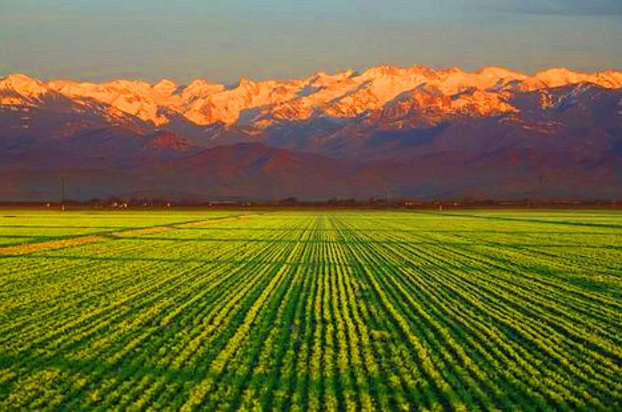
This property is located south of Alpaugh in Tulare County, Ca. Alpaugh is a census-designated place in Tulare County, Ca. The population was 1,026 at the 2010 census, up from 761 at the 2000 census.
It is named for John Alpaugh, one of the officers of the Home Extension Colony which reclaimed (or land speculated on) the land the town is built on. The site is located on the historic shoreline of Tulare Lake, once the largest freshwater lake in the USA outside of the Great lakes. Other towns built on its historic shores include Lemoore and Kettleman City.
Tulare County is a county in the state of California. Its county seat is Visalia. The county is named for Tulare Lake, once the largest freshwater lake west of the Great Lakes. Drained for agricultural development, the site is now in Kings County, which was created in 1893 from the western portion of the formerly larger Tulare County.
Tulare County comprises the Visalia-Porterville, CA Metropolitan Statistical Area. The county is located south of Fresno, spanning from the San Joaquin Valley east to the Sierra Nevada.
Sequoia National Park is located in the county, as are part of Kings Canyon National Park, in its northeast corner (shared with Fresno County), and part of Mount Whitney, on its eastern border (shared with Inyo County).
DONT MISS OUT ON THIS GREAT OPPORTUNITY!!
Property Profile:
APN: 330-070-054-000
Legal Description: ATWELL ISLAND TR LOT 175
Use: Vacant Land / Agricultural
Lot Size: 10 Acres / 435,600 sq. ft.
HOA: NO HOA fees
State/Province: California
Doc Type: Grant Deed
Taxes: Only $39 per year.
County: Tulare
City/ Location: Alpaugh, CA 93201 See Map.
The photos 2, 4, 6, 8, 10, and 12 show the actual property and the surrounding lots. Photos 1, 3, 5, 7, 9, and 11 shows general area.
We have also included a County Parcel Map and an aerial Map to help you. The assessor's parcel number to the property in Tulare is APN# 330-070-054-000
Here is a link (including the GPS coordinates) to view the location of the property on Google Maps:
35.835229,-119.526389
(You may have to copy and paste this to use it.) Once the map pops up, simply use the zoom tool on the left side of that screen to view the map in more detail. You can even view an aerial photo by clicking on the Satellite tab in the upper right portion of that screen.
All information we have on this property is disclosed within the content of the listing page. Any and all other information on this property should be directed toward the city or county of which the property is located in. Your due diligence should be performed, to ensure the property meets your needs and criteria.
From elevation to risk assessment
Search for detailed parcel information including; Elevation & Vegetation Maps, Ownership Information, Detailed Parcel Information, Crop History Map, Soil Survey Productivity Data, and more.
Research Parcel InformationLand for Sale by Javier Prodiz
Tulare County Properties By Type
- Farms for Sale in Tulare County, California
- Ranches for Sale in Tulare County, California
- Residential Property for Sale in Tulare County, California
- Undeveloped Land for Sale in Tulare County, California
- Commercial Property for Sale in Tulare County, California
- Lakefront Property for Sale in Tulare County, California
- Riverfront Property for Sale in Tulare County, California
- Horse Property for Sale in Tulare County, California
- Hunting Land for Sale in Tulare County, California
- Recreational Property for Sale in Tulare County, California
- Timberland for Sale in Tulare County, California
- Beachfront Property for Sale in Tulare County, California
Properties for Sale Nearby Counties
Tulare County Properties By City
- Alpaugh, California Land for Sale
- Badger, California Land for Sale
- California Hot Springs, California Land for Sale
- Camp Nelson, California Land for Sale
- Cutler, California Land for Sale
- Dinuba, California Land for Sale
- Ducor, California Land for Sale
- Earlimart, California Land for Sale
- Exeter, California Land for Sale
- Farmersville, California Land for Sale
- Goshen, California Land for Sale
- Ivanhoe, California Land for Sale
- More
- Kaweah, California Land for Sale
- Lemon Cove, California Land for Sale
- Lindsay, California Land for Sale
- Orosi, California Land for Sale
- Pixley, California Land for Sale
- Porterville, California Land for Sale
- Posey, California Land for Sale
- Richgrove, California Land for Sale
- Springville, California Land for Sale
- Strathmore, California Land for Sale
- Sultana, California Land for Sale
- Terra Bella, California Land for Sale
- Three Rivers, California Land for Sale
- Tipton, California Land for Sale
- Traver, California Land for Sale
- Tulare, California Land for Sale
- Visalia, California Land for Sale
- Waukena, California Land for Sale
- Woodlake, California Land for Sale
- Yettem, California Land for Sale
- Allensworth, California Land for Sale
- Balance Rock, California Land for Sale
- Cairns Corner, California Land for Sale
- East Orosi, California Land for Sale
- Elderwood, California Land for Sale
- London, California Land for Sale
- Poplar, California Land for Sale
- Tonyville, California Land for Sale
- Woodville, California Land for Sale
- Abilene, California Land for Sale
- Advance, California Land for Sale
- Ambler, California Land for Sale
- Angiola, California Land for Sale
- Antes, California Land for Sale
- Auckland, California Land for Sale
- Burr, California Land for Sale
- Cabin Cove, California Land for Sale
- Calgro, California Land for Sale
- Cameron Creek Colony, California Land for Sale
- Cedar Slope, California Land for Sale
- Chinowths Corner, California Land for Sale
- Citro, California Land for Sale
- Cotton Center, California Land for Sale
- Deer Creek Colony, California Land for Sale
- Delft Colony, California Land for Sale
- East Farmersville, California Land for Sale
- East Porterville, California Land for Sale
- El Mirador, California Land for Sale
- Elba, California Land for Sale
- Ellis Place, California Land for Sale
- Elmco, California Land for Sale
- Enson, California Land for Sale
- Fane, California Land for Sale
- Fayette, California Land for Sale
- Fountain Springs, California Land for Sale
- Gillete, California Land for Sale
- Globe, California Land for Sale
- Goodale, California Land for Sale
- Grant Grove Village, California Land for Sale
- Guernsey Mill, California Land for Sale
- Hammond, California Land for Sale
- Hartland, California Land for Sale
- Higby, California Land for Sale
- Hillmaid, California Land for Sale
- Idlewild, California Land for Sale
- Imhoff, California Land for Sale
- Ivory, California Land for Sale
- Johnsondale, California Land for Sale
- Jones Corner, California Land for Sale
- Jovista, California Land for Sale
- Lairds Corner, California Land for Sale
- Lemoncove, California Land for Sale
- Lindcove, California Land for Sale
- Lisko, California Land for Sale
- List, California Land for Sale
- Lois, California Land for Sale
- Loma, California Land for Sale
- Lort, California Land for Sale
- Lowes Corner, California Land for Sale
- Lucca, California Land for Sale
- Lumer, California Land for Sale
- Magnolia, California Land for Sale
- Matchin, California Land for Sale
- Merryman, California Land for Sale
- Midvalley, California Land for Sale
- Milo, California Land for Sale
- Mineral King, California Land for Sale
- Mirador, California Land for Sale
- Mitchell Corner, California Land for Sale
- Monson, California Land for Sale
- Nanceville, California Land for Sale
- Naranjo, California Land for Sale
- North Dinuba, California Land for Sale
- Octol, California Land for Sale
- Orris, California Land for Sale
- Paige, California Land for Sale
- Peral, California Land for Sale
- Pine Flat, California Land for Sale
- Pinewood, California Land for Sale
- Plainview, California Land for Sale
- Plano, California Land for Sale
- Pleasant View, California Land for Sale
- Ponca, California Land for Sale
- Ponderosa, California Land for Sale
- Poso Park, California Land for Sale
- Potwisha, California Land for Sale
- Quail, California Land for Sale
- Quaker Meadow, California Land for Sale
- Radnor, California Land for Sale
- Rayo, California Land for Sale
- Rector, California Land for Sale
- Red Fir, California Land for Sale
- Redbanks, California Land for Sale
- Redwood Corral, California Land for Sale
- Roads End, California Land for Sale
- Roche, California Land for Sale
- Saint Johns, California Land for Sale
- Saucelito, California Land for Sale
- Sequoia, California Land for Sale
- Seville, California Land for Sale
- Sierra Glen, California Land for Sale
- Silver City, California Land for Sale
- Smith Mill, California Land for Sale
- Spear Creek Summer Home Tract, California Land for Sale
- Spinks Corner, California Land for Sale
- Stoil, California Land for Sale
- Stone Place, California Land for Sale
- Stony Creek Village, California Land for Sale
- Stout, California Land for Sale
- Sugarloaf Mountain Park, California Land for Sale
- Sugarloaf Village, California Land for Sale
- Swall, California Land for Sale
- Tagus, California Land for Sale
- Taurusa, California Land for Sale
- Tokay, California Land for Sale
- Toolville, California Land for Sale
- Trocha, California Land for Sale
- Twin Buttes, California Land for Sale
- Ultra, California Land for Sale
- Vance, California Land for Sale
- Venida, California Land for Sale
- Vestal, California Land for Sale
- Vincent, California Land for Sale
- West Venida, California Land for Sale
- Westfield, California Land for Sale
- Wheatons, California Land for Sale
- White River, California Land for Sale
- White River Summer Home Tract, California Land for Sale
- Wilsonia, California Land for Sale
- Wimp, California Land for Sale
- Woodlake Junction, California Land for Sale
- Worth, California Land for Sale
- Wyeth, California Land for Sale
- Yokohl, California Land for Sale
- Zante, California Land for Sale