0.28 Acres El Paso Texas 51371 $110/mo
Description
Adventure awaits with this 0.28-acre parcel in El Paso, Texas, for just $110/month, perfect for outdoor lovers who crave wide-open skies, desert beauty, and endless exploration.
Whether you're into hiking, off-road adventures, or simply soaking in stunning sunsets, this land offers the ideal base to enjoy the natural wonders of West Texas.
Pricing options:
Cash Price: $3,200
Owner Finance: $3,400 ($300 doc fee/$0 down & 34 payments of $110.01 ($100 Loan Payment, $10.00 Service Fee, $0.01 property tax))
No credit check No interest No prepayment penalties
Note: The Doc Fee can be paid using a credit or debit card. Monthly payments must be paid using an ACH checking account/routing number from a bank in the United States.
Important: While you can camp and enjoy your property while making payments, permanent residency is not permitted until the land is fully paid off. Weekend camping and recreational use are welcome!
Property details:
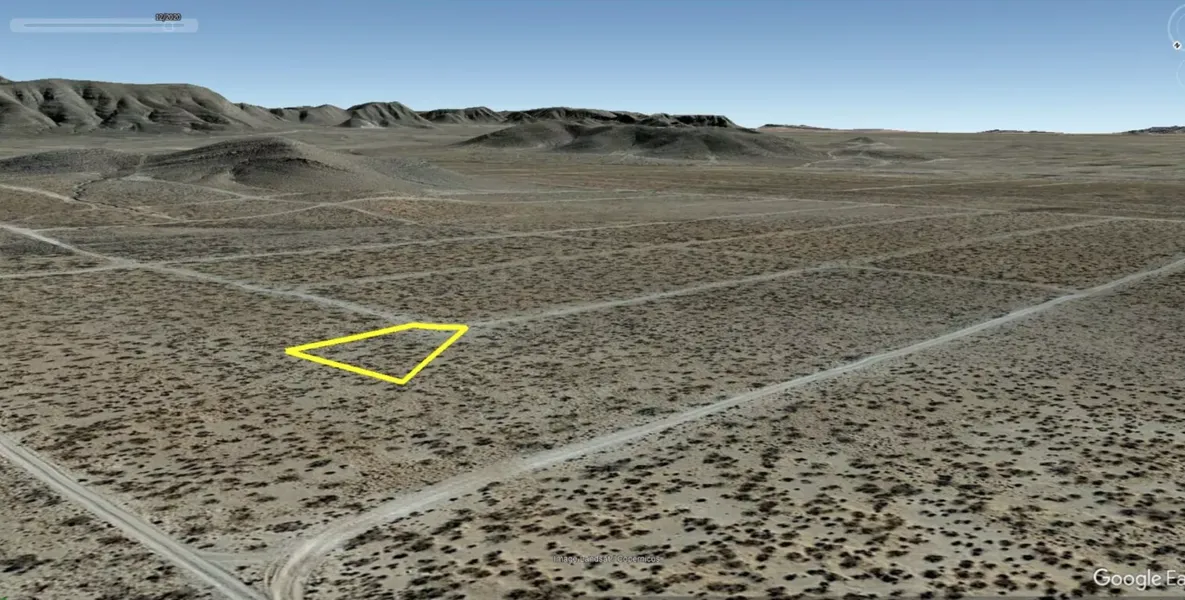
Acres: 0.28
Property ID: 51371
Legal Description: All of Lot 28 in Block 191 of SHADOW RIDGE ESTATES Unit No. 16, according to the map thereof recorded in the Office of the Clerk of El Paso County, Texas, including any gas, oil or mineral rights now owned by the Grantor.
Elevation: 4,198 ft.
Topography: Flat
Roads: Dirt
HOA/POA: No
Utilities: No
This is off-grid land. There are no city utilities here. You can use batteries, a generator, solar panels or a windmill for electricity.
For water you can bring it with you, drill a well, have water trucked in and delivered, set up a rain catchment system
Mineral Classified Lands: according to the Texas General Land office map, this property is mineral classified land, which means that the State of Texas owns the mineral rights and splits them 50/50 with the current surface owner.
State: Texas
County: El Paso
Property Tax: $0.07
Nearest Town: El Paso, TX
A phone app such as Land Glide or OnX Hunt can be used to find parcel lines and corners while walking the property (if using OnX Hunt, be sure to add the TX Private Lands map layer to see the parcel lines).
GPS Coordinates:
NorthWest Corner: 31.811750, -106.080619
SouthWest Corner: 31.811347, -106.080264
SouthEast Corner: 31.811403, -106.080136
NorthEast Corner: 31.811750, -106.080203
Area Attractions:
Franklin Mountains State Park-El Paso
Hueco Tanks State Historic Site-El Paso
Scenic Drive Overlook-El Paso
El Paso Zoo
Ready to make this property yours? Have questions? Contact us today to start your journey to land ownership in beautiful West Texas!
From elevation to risk assessment
Search for detailed parcel information including; Elevation & Vegetation Maps, Ownership Information, Detailed Parcel Information, Crop History Map, Soil Survey Productivity Data, and more.
Research Parcel InformationEnvironmental Factors
Resources
El Paso County Properties By Type
- Undeveloped Land for Sale in El Paso County, Texas
- Commercial Property for Sale in El Paso County, Texas
- Ranches for Sale in El Paso County, Texas
- Farms for Sale in El Paso County, Texas
- Residential Property for Sale in El Paso County, Texas
- Riverfront Property for Sale in El Paso County, Texas
- Horse Property for Sale in El Paso County, Texas
- Recreational Property for Sale in El Paso County, Texas
- Hunting Land for Sale in El Paso County, Texas
- Lakefront Property for Sale in El Paso County, Texas
- Beachfront Property for Sale in El Paso County, Texas
- Timberland for Sale in El Paso County, Texas
Properties for Sale Nearby Counties
El Paso County Properties By City
- Canutillo, Texas Land for Sale
- Clint, Texas Land for Sale
- El Paso, Texas Land for Sale
- Fabens, Texas Land for Sale
- San Elizario, Texas Land for Sale
- Tornillo, Texas Land for Sale
- Buford, Texas Land for Sale
- Horizon City, Texas Land for Sale
- Socorro, Texas Land for Sale
- Vinton, Texas Land for Sale
- Aero Vista, Texas Land for Sale
- Alamo Alto, Texas Land for Sale
- More
- Alfalfa, Texas Land for Sale
- Anthony, Texas Land for Sale
- Belen, Texas Land for Sale
- Borderland, Texas Land for Sale
- Britton Davis, Texas Land for Sale
- Butterfield, Texas Land for Sale
- Cielo Vista, Texas Land for Sale
- Colonia de las Azaleas, Texas Land for Sale
- Colonia de las Dalias, Texas Land for Sale
- Coronado Hills, Texas Land for Sale
- Courchesne, Texas Land for Sale
- Cuadrilla, Texas Land for Sale
- Del Norte Acres, Texas Land for Sale
- Del Norte Heights, Texas Land for Sale
- Hacienda Heights, Texas Land for Sale
- Homestead Meadows, Texas Land for Sale
- La Guna, Texas Land for Sale
- La Tuna, Texas Land for Sale
- Loma Terrace, Texas Land for Sale
- Mission Hills, Texas Land for Sale
- Montoya, Texas Land for Sale
- Morning Glory, Texas Land for Sale
- Newman, Texas Land for Sale
- Nuway, Texas Land for Sale
- Planeport, Texas Land for Sale
- Prado Verde, Texas Land for Sale
- Smeltertown, Texas Land for Sale
- Sunrise Acres, Texas Land for Sale
- Tigua, Texas Land for Sale
- Ysleta, Texas Land for Sale