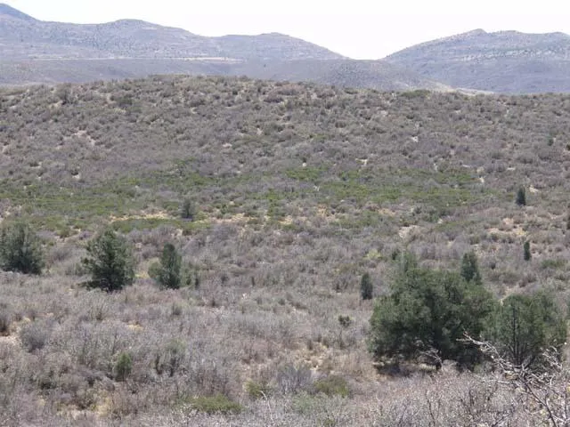
10.03 Acres, Yavapai County AZ, Parcel 302-17-095B
*** GUARANTEED FINANCING- No Credit Check***
Your Dream Escape Awaits in ASH FORK, AZ - With a Money Back Satisfaction Guarantee!
Discover the Freedom of Off-Grid Living!
Ever dreamed of owning a piece of Arizona's majestic landscapes? This is your chance to turn those dreams into reality with guaranteed seller-financing on a sprawling 10.03-acre property in Ash Fork, AZ. With a low down payment and no credit check required, your path to land ownership has never been easier or more secure.
Don't let this opportunity pass. With flexible, guaranteed financing on this property with a low down payment and no credit check and a commitment to your satisfaction, owning a piece of Ash Fork, AZ, has never been more attainable or appealing.
Contact us now to secure your piece of freedom!
Property Details:
Lot Size: 10.03
County: Yavapi
Address: ASH FORK, AZ, 86320
Terrain: Level
Power: Off Grid. Solar or altenatives
Water: Well or holding tank would have to be installed
Septic/Sewer: Septic system would need to be installed
Gas: Off Grid. - Fuel and Propane
Access: Praire Dog Rd
HOA/ POA: no HOA
APN: 302-17-095B
Other information or restrictions:
RVs Allowed: No travel trailers, motor homes or recreational vehicles shall be made suitable for long-term occupancy without one of the following: Temporary Dwelling Permit, Use Permit or Secondary Medical Dwelling Variance.
Camp on Property: "Camping is allowed in RCU zoning 2-acre minimum lots 10 days at a time, 3 times a year, 30 days in between each stay"
Mobile Homes Allowed: You can put a mobile home on your property if you get the building permits and it meets all the codes.
*** Buyer to verify all information***
Closest Town/City: Paulden, Arizona
Average annual precipitation: 14 inches of rain/ 8.4 inches of snow
Average Temperature(winter/summer): 23/93
Approx. Coordinates: 35.1857, -112.6431
From elevation to risk assessment
Search for detailed parcel information including; Elevation & Vegetation Maps, Ownership Information, Detailed Parcel Information, Crop History Map, Soil Survey Productivity Data, and more.
Research Parcel InformationEnvironmental Factors
Resources
Land for Sale by APXN
Yavapai County Properties By Type
- Undeveloped Land for Sale in Yavapai County, Arizona
- Residential Property for Sale in Yavapai County, Arizona
- Ranches for Sale in Yavapai County, Arizona
- Farms for Sale in Yavapai County, Arizona
- Horse Property for Sale in Yavapai County, Arizona
- Commercial Property for Sale in Yavapai County, Arizona
- Recreational Property for Sale in Yavapai County, Arizona
- Timberland for Sale in Yavapai County, Arizona
- Riverfront Property for Sale in Yavapai County, Arizona
- Lakefront Property for Sale in Yavapai County, Arizona
- Hunting Land for Sale in Yavapai County, Arizona
- Beachfront Property for Sale in Yavapai County, Arizona
Properties for Sale Nearby Counties
Yavapai County Properties By City
- Ash Fork, Arizona Land for Sale
- Bagdad, Arizona Land for Sale
- Black Canyon City, Arizona Land for Sale
- Camp Verde, Arizona Land for Sale
- Chino Valley, Arizona Land for Sale
- Clarkdale, Arizona Land for Sale
- Congress, Arizona Land for Sale
- Cornville, Arizona Land for Sale
- Cottonwood, Arizona Land for Sale
- Crown King, Arizona Land for Sale
- Dewey, Arizona Land for Sale
- Humboldt, Arizona Land for Sale
- More
- Iron Springs, Arizona Land for Sale
- Jerome, Arizona Land for Sale
- Kirkland, Arizona Land for Sale
- Lake Montezuma, Arizona Land for Sale
- Mayer, Arizona Land for Sale
- Paulden, Arizona Land for Sale
- Prescott, Arizona Land for Sale
- Prescott Valley, Arizona Land for Sale
- Rimrock, Arizona Land for Sale
- Sedona, Arizona Land for Sale
- Seligman, Arizona Land for Sale
- Skull Valley, Arizona Land for Sale
- Yarnell, Arizona Land for Sale
- Cordes Lakes, Arizona Land for Sale
- Groom Creek, Arizona Land for Sale
- Peeples Valley, Arizona Land for Sale
- Rock Springs, Arizona Land for Sale
- Spring Valley, Arizona Land for Sale
- Abra, Arizona Land for Sale
- Apron Crossing, Arizona Land for Sale
- Arcosanti, Arizona Land for Sale
- Arnold Place, Arizona Land for Sale
- Audley, Arizona Land for Sale
- Aultman, Arizona Land for Sale
- Baldwin Place, Arizona Land for Sale
- Baldwins Crossing, Arizona Land for Sale
- Bear, Arizona Land for Sale
- Big Park, Arizona Land for Sale
- Big Reef Mill, Arizona Land for Sale
- Bignotti, Arizona Land for Sale
- Blue Hills Farms, Arizona Land for Sale
- Bradshaw City, Arizona Land for Sale
- Breezy Pines, Arizona Land for Sale
- Bridgeport, Arizona Land for Sale
- Briggs, Arizona Land for Sale
- Bumble Bee, Arizona Land for Sale
- Burro John, Arizona Land for Sale
- Casa Rosa, Arizona Land for Sale
- Castle Canyon Mesa, Arizona Land for Sale
- Castle Hot Springs, Arizona Land for Sale
- Cedar Mill, Arizona Land for Sale
- Centerville, Arizona Land for Sale
- Cherry, Arizona Land for Sale
- Chilean Mill, Arizona Land for Sale
- Clear Creek, Arizona Land for Sale
- Cleator, Arizona Land for Sale
- Clemenceau, Arizona Land for Sale
- Columbia, Arizona Land for Sale
- Congress Junction, Arizona Land for Sale
- Constellation, Arizona Land for Sale
- Copperopolis, Arizona Land for Sale
- Cordes, Arizona Land for Sale
- Cordes Junction, Arizona Land for Sale
- Crookton, Arizona Land for Sale
- Dandrea, Arizona Land for Sale
- Date, Arizona Land for Sale
- Del Rio, Arizona Land for Sale
- Dewey-Humboldt, Arizona Land for Sale
- Diamond Valley, Arizona Land for Sale
- Drake, Arizona Land for Sale
- Dugas, Arizona Land for Sale
- East Fort, Arizona Land for Sale
- Eddy Place, Arizona Land for Sale
- Entro, Arizona Land for Sale
- Ferguson Place Windmill, Arizona Land for Sale
- Flores, Arizona Land for Sale
- Flower Pot, Arizona Land for Sale
- Forbing Park, Arizona Land for Sale
- Fort Misery, Arizona Land for Sale
- Fort River Caves, Arizona Land for Sale
- Fort Whipple, Arizona Land for Sale
- Gillette, Arizona Land for Sale
- Glen Ilah, Arizona Land for Sale
- Glen Oaks, Arizona Land for Sale
- Goodwin, Arizona Land for Sale
- Grand View, Arizona Land for Sale
- Granite Dells, Arizona Land for Sale
- Granite Siding, Arizona Land for Sale
- Hawkins, Arizona Land for Sale
- Hecla, Arizona Land for Sale
- Highland Park, Arizona Land for Sale
- Highland Pines, Arizona Land for Sale
- Hillside, Arizona Land for Sale
- Hooper, Arizona Land for Sale
- Humbug, Arizona Land for Sale
- Jordan, Arizona Land for Sale
- Jordan Meadows, Arizona Land for Sale
- Juniper Heights, Arizona Land for Sale
- Kirkland Junction, Arizona Land for Sale
- Lancaster, Arizona Land for Sale
- Lapham, Arizona Land for Sale
- Lawrence Crossing, Arizona Land for Sale
- Lehman Mill, Arizona Land for Sale
- Mack, Arizona Land for Sale
- McGuireville, Arizona Land for Sale
- McNary Place, Arizona Land for Sale
- Middle Verde, Arizona Land for Sale
- Miller Valley, Arizona Land for Sale
- Minnehaha, Arizona Land for Sale
- Mint, Arizona Land for Sale
- Oak Creek, Arizona Land for Sale
- Oak Knoll Village, Arizona Land for Sale
- Ocotillo, Arizona Land for Sale
- Octave, Arizona Land for Sale
- P and E Junction, Arizona Land for Sale
- Packer, Arizona Land for Sale
- Page Springs, Arizona Land for Sale
- Paradise Acres, Arizona Land for Sale
- Paxton Place, Arizona Land for Sale
- Perkinsville, Arizona Land for Sale
- Pica, Arizona Land for Sale
- Piedmont, Arizona Land for Sale
- Pinaveta, Arizona Land for Sale
- Pioneer Acres, Arizona Land for Sale
- Poland Junction, Arizona Land for Sale
- Ponderosa Park, Arizona Land for Sale
- Potato Patch, Arizona Land for Sale
- Reddells Ranch Acres, Arizona Land for Sale
- Rush Place Windmill, Arizona Land for Sale
- Sand Mill, Arizona Land for Sale
- Security Acres, Arizona Land for Sale
- Smelter City, Arizona Land for Sale
- South Fort, Arizona Land for Sale
- Stanton, Arizona Land for Sale
- Stringfield, Arizona Land for Sale
- Sycamore, Arizona Land for Sale
- Tapco, Arizona Land for Sale
- Tres Rios, Arizona Land for Sale
- Tutt, Arizona Land for Sale
- Venezia, Arizona Land for Sale
- Verde, Arizona Land for Sale
- Verde Village, Arizona Land for Sale
- Wagoner, Arizona Land for Sale
- Walker, Arizona Land for Sale
- Walker Place Windmill, Arizona Land for Sale
- Walnut Grove, Arizona Land for Sale
- West Sedona, Arizona Land for Sale
- Whipple, Arizona Land for Sale
- Wilhoit, Arizona Land for Sale
- Williamson, Arizona Land for Sale
- Willow Spring, Arizona Land for Sale
- Wingfield, Arizona Land for Sale
- Wood Trap, Arizona Land for Sale
- Yampai, Arizona Land for Sale
- Yava, Arizona Land for Sale
- Yavapai Hills, Arizona Land for Sale