Private, Tree Covered Mountain Retreat on 4.7 Acres!
Description
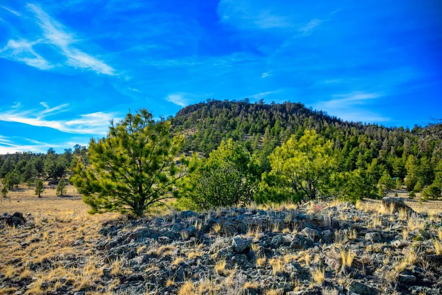
Tucked away just 11 miles south of Hartsel, this 4.7 acre parcel offers the perfect balance of privacy, scenery, and access, making it an ideal spot for a peaceful off grid escape or future cabin surrounded by nature.
The land gently slopes up from the road toward a central hill featuring attractive natural rock outcroppings, then rolls back down toward the rear of the property where the trees provide excellent privacy and a tucked away feel. A heavily tree covered ridge across the road to the west enhances the sense of seclusion, while beautiful mountain views to the north and wide open sightlines in every direction deliver true 360 degree scenery.
Top Features
Established Tree Cover Ideal balance of privacy and usability
Gently Rolling Terrain Flexible layout for building or camping
Natural Rock Outcroppings Scenic features adding character and visual appeal
Secluded Cabin Potential Private spots toward the back of the lot surrounded by trees
Incredible Views Mountain views to the north with scenic ridges all around
Convenient Access Less than 5 miles from Hwy 9
With privacy, character, and sweeping Colorado views all wrapped into one accessible parcel, this 4.7 acre property is an exceptional opportunity to build, escape, or invest in mountain land with lasting appeal!
Owner financing available on all properties and everyone qualifies. We also include a 15% prepayment discount if you want to pay off early and save! Contact us or check out our site for more information on available options.
SUBDIVISION: ESTATES OF COLORADO
ADDRESS: Black Beaver Rd, Hartsel, CO 80449
SIZE: 4.7 acres
APN: 8335
LEGAL DESCRIPTION: Estate 1810, Estates of Colorado, Unit 36 Amended, according to the plat thereof recorded at Reception No. 181382, County of Park, State of Colorado.
APPROX. GPS COORDINATES:
NW: 38.894544, -105.734242
NE: 38.894805, -105.732479
SE: 38.893593, -105.732329
SW: 38.893395, -105.734085
APPROX. ELEVATION: 9,273 ft
ZONING: Residential
CAMPING & RVs: Both RV and Tent Short Term
IMPROVEMENTS: None
ANNUAL TAXES: Approx. $226
HOA/POA FEES: None
SEWER: Would need septic system if building.
WATER: Would be by well, holding tank or other similar option.
UTILITIES: Solar or generator best options for electricity. Gas by propane tank. Phone by cellular.
ACCESS: County dirt road. Accessible by car weather permitting or with four-wheel drive vehicle in inclement weather.
From elevation to risk assessment
Search for detailed parcel information including; Elevation & Vegetation Maps, Ownership Information, Detailed Parcel Information, Crop History Map, Soil Survey Productivity Data, and more.
Research Parcel InformationDirections
Please use this google maps link for the best driving directions: https://maps.app.goo.gl/wmuPyj4Zx51J3mNn7
Environmental Factors
Resources
Park County Properties By Type
- Undeveloped Land for Sale in Park County, Colorado
- Ranches for Sale in Park County, Colorado
- Residential Property for Sale in Park County, Colorado
- Riverfront Property for Sale in Park County, Colorado
- Lakefront Property for Sale in Park County, Colorado
- Horse Property for Sale in Park County, Colorado
- Timberland for Sale in Park County, Colorado
- Beachfront Property for Sale in Park County, Colorado
- Farms for Sale in Park County, Colorado
- Hunting Land for Sale in Park County, Colorado
- Recreational Property for Sale in Park County, Colorado
- Commercial Property for Sale in Park County, Colorado
Properties for Sale Nearby Counties
Park County Properties By City
- Alma, Colorado Land for Sale
- Bailey, Colorado Land for Sale
- Como, Colorado Land for Sale
- Fairplay, Colorado Land for Sale
- Grant, Colorado Land for Sale
- Guffey, Colorado Land for Sale
- Hartsel, Colorado Land for Sale
- Jefferson, Colorado Land for Sale
- Lake George, Colorado Land for Sale
- Shawnee, Colorado Land for Sale
- Tarryall, Colorado Land for Sale
- Alma Junction, Colorado Land for Sale
- More
- Antero Junction, Colorado Land for Sale
- Balfour, Colorado Land for Sale
- Bordenville, Colorado Land for Sale
- Estabrook, Colorado Land for Sale
- Garo, Colorado Land for Sale
- Glenisle, Colorado Land for Sale
- Glentivar, Colorado Land for Sale
- Haver, Colorado Land for Sale
- Insmont, Colorado Land for Sale
- Peabodys, Colorado Land for Sale
- Pike-San Isabel Village, Colorado Land for Sale
- Platte Springs, Colorado Land for Sale
- Santa Maria, Colorado Land for Sale
- Singleton, Colorado Land for Sale
- Trump, Colorado Land for Sale
- Webster, Colorado Land for Sale
- Weller, Colorado Land for Sale
- Will-O-The-Wisp, Colorado Land for Sale