Half Acre RV Friendly Lot Near Navajo Dam, NM
This half acre lot is RV and camping friendly. The Navajo Lake Marina is 30 minutes away. Navajo Lake Marina has many different activities including boat/house boat rentals, kayak rentals, fishing and fishing guides, a restaurant and a marina store. The Frances Canyon Navajo Ruins are a 22 minute drive to the southeast where you can explore old Indian ruins. Archuleta which is to the west, is just over half an hour away and will have all the food and supplies you need.
Utility lines appear to be located 400 away to the west, however, prospective buyers should confirm this if they have any plans that will require electricity. On the other hand, solar panels could be used to have a totally off-grid property. While this is an RV and camping friendly lot, a tiny home or something similar would work well here.
The property has both legal and physical access, however, the road leading up to the property may be a little rough.
County: Rio Arriba
City: Navajo Dam
State: New Mexico
Zip: 87412
APN: R030119
Acreage: .5 Acre
Price: $3,900
Property Type: Rural Residential
Zoning: Residential
Terrain: Flat
Elevation: 6,214
Best Attribute: Location/price
Legal Description: Navajo Lake Subdivision Block 12 Lot 4
Power: In the area, buyer confirm
Phone: Cell
Water: Buyer confirm
Sewer: Alternative
Roads: Paved dirt
Time to Build: None
Title Information: Clear title
Annual Property Taxes (approx.): $24.84
HOA/ Misc Fees: None
GPS Coordinates: 36.7846684013662, -107.525144086048
Copy and paste the above set of coordinates into the search engine of choice or your smartphone map app. This will show you the exact location of the property and how to navigate to it.
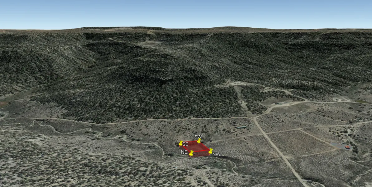
Property Corner Points (refer to reference picture):
NW 36.784700, -107.525200
NE 36.784701, -107.524800
SE 36.784199, -107.524800
SW 36.784199, -107.525201
Document Fee: $100 (covers everything needed to get the property into your name)
Terms: Cash
From elevation to risk assessment
Search for detailed parcel information including; Elevation & Vegetation Maps, Ownership Information, Detailed Parcel Information, Crop History Map, Soil Survey Productivity Data, and more.
Research Parcel InformationDirections
GPS Coordinates: 36.7846684013662, -107.525144086048
Copy and paste the above set of coordinates into the search engine of choice or your smartphone map app. This will show you the exact location of the property and how to navigate to it.
Resources
Land for Sale by Christian Stahlberg
Rio Arriba County Properties By Type
- Ranches for Sale in Rio Arriba County, New Mexico
- Residential Property for Sale in Rio Arriba County, New Mexico
- Undeveloped Land for Sale in Rio Arriba County, New Mexico
- Riverfront Property for Sale in Rio Arriba County, New Mexico
- Farms for Sale in Rio Arriba County, New Mexico
- Lakefront Property for Sale in Rio Arriba County, New Mexico
- Hunting Land for Sale in Rio Arriba County, New Mexico
- Commercial Property for Sale in Rio Arriba County, New Mexico
- Recreational Property for Sale in Rio Arriba County, New Mexico
- Timberland for Sale in Rio Arriba County, New Mexico
- Horse Property for Sale in Rio Arriba County, New Mexico
- Beachfront Property for Sale in Rio Arriba County, New Mexico
Properties for Sale Nearby Counties
- Archuleta County, New Mexico Land for Sale
- Conejos County, New Mexico Land for Sale
- Los Alamos County, New Mexico Land for Sale
- Mora County, New Mexico Land for Sale
- San Juan County, New Mexico Land for Sale
- Sandoval County, New Mexico Land for Sale
- Santa Fe County, New Mexico Land for Sale
- Taos County, New Mexico Land for Sale
Rio Arriba County Properties By City
- Abiquiu, New Mexico Land for Sale
- Alcalde, New Mexico Land for Sale
- Canjilon, New Mexico Land for Sale
- Cebolla, New Mexico Land for Sale
- Chama, New Mexico Land for Sale
- Chimayo, New Mexico Land for Sale
- Cordova, New Mexico Land for Sale
- Coyote, New Mexico Land for Sale
- Dixon, New Mexico Land for Sale
- Dulce, New Mexico Land for Sale
- El Rito, New Mexico Land for Sale
- Embudo, New Mexico Land for Sale
- More
- Espanola, New Mexico Land for Sale
- Hernandez, New Mexico Land for Sale
- La Madera, New Mexico Land for Sale
- Lindrith, New Mexico Land for Sale
- Los Ojos, New Mexico Land for Sale
- Medanales, New Mexico Land for Sale
- Petaca, New Mexico Land for Sale
- San Juan Pueblo, New Mexico Land for Sale
- Tierra Amarilla, New Mexico Land for Sale
- Truchas, New Mexico Land for Sale
- Vallecitos, New Mexico Land for Sale
- Velarde, New Mexico Land for Sale
- Youngsville, New Mexico Land for Sale
- Barranca, New Mexico Land for Sale
- Brazos, New Mexico Land for Sale
- Chamita, New Mexico Land for Sale
- Chili, New Mexico Land for Sale
- Cundiyo, New Mexico Land for Sale
- El Duende, New Mexico Land for Sale
- El Llano, New Mexico Land for Sale
- El Rancho, New Mexico Land for Sale
- El Vado, New Mexico Land for Sale
- Ensenada, New Mexico Land for Sale
- Estaca, New Mexico Land for Sale
- Fairview, New Mexico Land for Sale
- Guachupangue, New Mexico Land for Sale
- Guique, New Mexico Land for Sale
- La Bolsa, New Mexico Land for Sale
- La Junta, New Mexico Land for Sale
- La Mesilla, New Mexico Land for Sale
- La Puebla, New Mexico Land for Sale
- La Puente, New Mexico Land for Sale
- Las Placitas, New Mexico Land for Sale
- Las Tablas, New Mexico Land for Sale
- Lumberton, New Mexico Land for Sale
- Ojito, New Mexico Land for Sale
- Pajarito, New Mexico Land for Sale
- Pueblito, New Mexico Land for Sale
- Rio Chiquito, New Mexico Land for Sale
- Riverside, New Mexico Land for Sale
- Rutheron, New Mexico Land for Sale
- San Pedro, New Mexico Land for Sale
- Santa Clara Pueblo, New Mexico Land for Sale
- Sombrillo, New Mexico Land for Sale
- Alire, New Mexico Land for Sale
- Amargo, New Mexico Land for Sale
- Ancones, New Mexico Land for Sale
- Apodaca, New Mexico Land for Sale
- Arroyo del Agua, New Mexico Land for Sale
- Big Horn, New Mexico Land for Sale
- Cañones, New Mexico Land for Sale
- Canova, New Mexico Land for Sale
- Carracas, New Mexico Land for Sale
- Clara Peak, New Mexico Land for Sale
- Crowther Cow Camp, New Mexico Land for Sale
- Duranes, New Mexico Land for Sale
- El Curuco, New Mexico Land for Sale
- El Guacho, New Mexico Land for Sale
- El Monte Rojo, New Mexico Land for Sale
- Frijoles Spring, New Mexico Land for Sale
- Jarosa, New Mexico Land for Sale
- La Careda, New Mexico Land for Sale
- La Chuachia, New Mexico Land for Sale
- La Cienaga, New Mexico Land for Sale
- La Cuestecita, New Mexico Land for Sale
- La Villita, New Mexico Land for Sale
- LaMadera, New Mexico Land for Sale
- Lava, New Mexico Land for Sale
- Lobato, New Mexico Land for Sale
- Los Luceros, New Mexico Land for Sale
- Los Pinos, New Mexico Land for Sale
- Lower Cañones, New Mexico Land for Sale
- Lybrook, New Mexico Land for Sale
- Lyden, New Mexico Land for Sale
- Monero, New Mexico Land for Sale
- Montecito, New Mexico Land for Sale
- Navajo City, New Mexico Land for Sale
- Plaza Blanca, New Mexico Land for Sale
- Puye, New Mexico Land for Sale
- Recheulos, New Mexico Land for Sale
- Rio Puerco, New Mexico Land for Sale
- Santo Niño, New Mexico Land for Sale
- South Petaca, New Mexico Land for Sale
- Sublette, New Mexico Land for Sale
- Tapicitoes, New Mexico Land for Sale
- Tierra Azul, New Mexico Land for Sale
- Toltec, New Mexico Land for Sale
- Vallecitos Corrales, New Mexico Land for Sale
- Willow Creek, New Mexico Land for Sale
- Wright Place, New Mexico Land for Sale
- Gallina, New Mexico Land for Sale