Great investment property in Thomasville, GA!
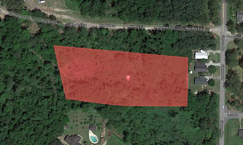
This property is located in Thomasville in the Red Hills Region in the southwest part of Georgia. Dubbed as a winter vacation destination due to its warm temperatures, and pine-scented air, this town is known as the City of Roses. The property is 3.37 acres and is optimal for investment since it's right where the action is happening. Please note, as it is, you can't use the property until you've built a driveway or applied for an easement to gain legal access to the property. If you're willing to invest a bit of effort into making it happen then you've got a goldmine in your hands! Appreciation rates since 2000 have gone up 74.18% (ending value as of Q4 2020). Just a couple of miles away to downtown Thomasville, imagine having a property within a city that is considered a top destination for golfing, fishing, and Quail hunting. With the area rapidly being developed and only having 16.1% remaining as vacant land in the area, you sure don't want to miss out on this prime investment opportunity!
Nearby Towns From The Property:
Thomasville (6 min from the property), Cairo (18 min from the property), Moultrie (33 min from the property), Valdosta (54 min from the property), Albany (69 min from the property)
Attractions near the property:
The Big Oak | 5 min. from the property
Cherokee Lake Park | 8 min. from the property
The Thomasville History Center | 4 min. from the property
Lost Creek Forest | 14 min. from the property
Millpond | 15 min. from the property
Flowers History in the Baking | 6 min. from the property
MacIntyre Park | 3 min. from the property
Property Details:
State: Georgia
County: Thomas
APN: 013-004004-B
Conveyance: Warranty Deed
Title: Free & Clear
Address: TBD
Center GPS: 30.864680, -83.978360
Size: 3.37 acre
Zoning: Agricultural - A
Access: No Legal Access
Power: Power Available On Street
Water: Well Available On Street
Sewage: Sewer Available On Street
Gas: Propane
Phone: AT&T, Verizon, T-mobile
Internet: Xfinity, Centurylink, Viasat
General Elevation: 279 ft
Terrain: Flat
Camping/RV: Not Permitted
Mobile Homes: Mobile Home Temporary Use Only And To Be Terminated Upon Completion Of Construction Of Stick Build Home.
Property Taxes: Approximately $27.00/yr
Property HOA: None
From elevation to risk assessment
Search for detailed parcel information including; Elevation & Vegetation Maps, Ownership Information, Detailed Parcel Information, Crop History Map, Soil Survey Productivity Data, and more.
Research Parcel InformationDirections
Simply enter any of these GPS coordinates in your favorite maps software to find it. See below for approximate coordinates:
Center: 30.864680, -83.978360
Northwest Corner: 30.865130, -83.979460
Northeast Corner: 30.864980, -83.977480
Southwest Corner: 30.864450, -83.979280
Southeast Corner: 30.864360, -83.977490
Resources
Land for Sale by Debrosland
Thomas County Properties By Type
- Farms for Sale in Thomas County, Georgia
- Undeveloped Land for Sale in Thomas County, Georgia
- Hunting Land for Sale in Thomas County, Georgia
- Residential Property for Sale in Thomas County, Georgia
- Ranches for Sale in Thomas County, Georgia
- Timberland for Sale in Thomas County, Georgia
- Recreational Property for Sale in Thomas County, Georgia
- Commercial Property for Sale in Thomas County, Georgia
- Riverfront Property for Sale in Thomas County, Georgia
- Lakefront Property for Sale in Thomas County, Georgia
- Horse Property for Sale in Thomas County, Georgia
- Beachfront Property for Sale in Thomas County, Georgia
Properties for Sale Nearby Counties
Thomas County Properties By City
- Boston, Georgia Land for Sale
- Coolidge, Georgia Land for Sale
- Meigs, Georgia Land for Sale
- Ochlocknee, Georgia Land for Sale
- Thomasville, Georgia Land for Sale
- Hinsonton, Georgia Land for Sale
- Metcalf, Georgia Land for Sale
- Booker Heights, Georgia Land for Sale
- Chastain, Georgia Land for Sale
- Dawesville, Georgia Land for Sale
- Dewey City, Georgia Land for Sale
- Dillon, Georgia Land for Sale
- More
- Eason, Georgia Land for Sale
- Five Forks, Georgia Land for Sale
- Fletcherville, Georgia Land for Sale
- Fredonia, Georgia Land for Sale
- Glasgow, Georgia Land for Sale
- Hansell, Georgia Land for Sale
- Homestead Park, Georgia Land for Sale
- McLoughlin Heights, Georgia Land for Sale
- Merrillville, Georgia Land for Sale
- Newark, Georgia Land for Sale
- Pasco, Georgia Land for Sale
- Patten, Georgia Land for Sale
- Pebble Hill, Georgia Land for Sale
- Quality, Georgia Land for Sale
- Theodore Heights, Georgia Land for Sale