39.86 Acres • Surveyed • Road Access * Views -$349.00/Month-No Credit Check
Owner Financing-No Credit Check!
$28,995.00 Sale Price
$349.00 a month payment
No Credit Check
Deposit $595.00
2.5 Interest
No Prepayment Penalty
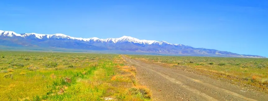
39.86 Acres • Surveyed • Perfect Access • Mountain & Valley Viewshis perfectly located 39.86-acre parcel offers everything land buyers hope to find in Northern Nevada. Fully surveyed, with clear easement access, and positioned just feet from the county-maintained Coal Canyon–Stillwater Road, this property delivers some of the best access you’ll find anywhere in Buena Vista Valley. Getting in and out will absolutely NEVER be an issue.
Even better, this land adjoins 619 acres of BLM on its south side, giving you protected views, extra privacy, and endless room to explore.
Situated just half a mile from the corner of Buena Vista Valley Road and Coal Canyon, you have unbeatable proximity to main travel routes while still enjoying wide-open peace and quiet.
Surrounded by mountains and valleys in every direction, the scenery here is pure Nevada—dramatic, expansive, and absolutely unforgettable.
Whether you're looking to build a ranch, establish a recreational basecamp, or invest in a long-term Nevada land hold, this 39.86-acre parcel checks every box!
PROPERTY INFORMATION
APN: 015-220-13
Legal Description: Township 25 North, Range 34 East, M.D.B.&M. West 1/2 of section 11
?Exact Acreage: 39.96
?County: Pershing
?Elevation: 4,150ft
?Special Notes: TBD
?Annual Property Taxes: $87.61
?Annual HOA Fees: None
LOCATION & ACCESS
Centroid
40.059571, -118.147378
Corners
NW 40.061362, -118.149748
NE 40.061362, -118.144998
SE 40.057753, -118.145004
SW 40.057743, -118.149715
From elevation to risk assessment
Search for detailed parcel information including; Elevation & Vegetation Maps, Ownership Information, Detailed Parcel Information, Crop History Map, Soil Survey Productivity Data, and more.
Research Parcel InformationDirections
PROPERTY INFORMATION
APN: 015-220-13
Legal Description: Township 25 North, Range 34 East, M.D.B.&M. West 1/2 of section 11
?Exact Acreage: 39.96
?County: Pershing
?Elevation: 4,150ft
?Special Notes: TBD
?Annual Property Taxes: $87.61
?Annual HOA Fees: None
LOCATION & ACCESS
Centroid
40.059571, -118.147378
Corners
NW 40.061362, -118.149748
NE 40.061362, -118.144998
SE 40.057753, -118.145004
SW 40.057743, -118.149715
Follow I-80 W/US-95 S to Pershing County. Take exit 112 from I-80 W/US-95 S
52 min (63.5 mi)
?
Follow NV-396 and Coal Canyon-Stillwater Rd to your destination
32 min (19.8 mi)
Turn left onto NV-396/US-95 BUS N/Coal Canyon Rd
? Continue to follow NV-396
?
13.2 mi
Continue onto Coal Canyon-Stillwater Rd
?
1.5 mi
Turn left to stay on Coal Canyon-Stillwater Rd
?
4.9 mi
Turn left
? Destination will be on the left
Land for Sale by Mark Genis
Previously Sold by Mark Genis
Pershing County Properties By Type
- Undeveloped Land for Sale in Pershing County, Nevada
- Residential Property for Sale in Pershing County, Nevada
- Hunting Land for Sale in Pershing County, Nevada
- Recreational Property for Sale in Pershing County, Nevada
- Ranches for Sale in Pershing County, Nevada
- Lakefront Property for Sale in Pershing County, Nevada
- Farms for Sale in Pershing County, Nevada
- Riverfront Property for Sale in Pershing County, Nevada
- Commercial Property for Sale in Pershing County, Nevada
- Horse Property for Sale in Pershing County, Nevada
- Timberland for Sale in Pershing County, Nevada
- Beachfront Property for Sale in Pershing County, Nevada
Properties for Sale Nearby Counties
Pershing County Properties By City
- Imlay, Nevada Land for Sale
- Lovelock, Nevada Land for Sale
- Cosgrave, Nevada Land for Sale
- Humboldt, Nevada Land for Sale
- Mill City, Nevada Land for Sale
- Oreana, Nevada Land for Sale
- Rye Patch, Nevada Land for Sale
- Toulon, Nevada Land for Sale
- Tungsten, Nevada Land for Sale
- Unionville, Nevada Land for Sale
- Arabia, Nevada Land for Sale
- Colado, Nevada Land for Sale
- More
- Fitting, Nevada Land for Sale
- Granite Point, Nevada Land for Sale
- Humboldt City, Nevada Land for Sale
- Humboldt House, Nevada Land for Sale
- Kodak, Nevada Land for Sale
- Kyle Hot Springs, Nevada Land for Sale
- Lower Rochester, Nevada Land for Sale
- Nightingale, Nevada Land for Sale
- Panama, Nevada Land for Sale
- Perth, Nevada Land for Sale
- Placerites, Nevada Land for Sale
- Poker Brown, Nevada Land for Sale
- Rochester, Nevada Land for Sale
- Scossa, Nevada Land for Sale
- Trego, Nevada Land for Sale
- Twain, Nevada Land for Sale
- Woolsey, Nevada Land for Sale