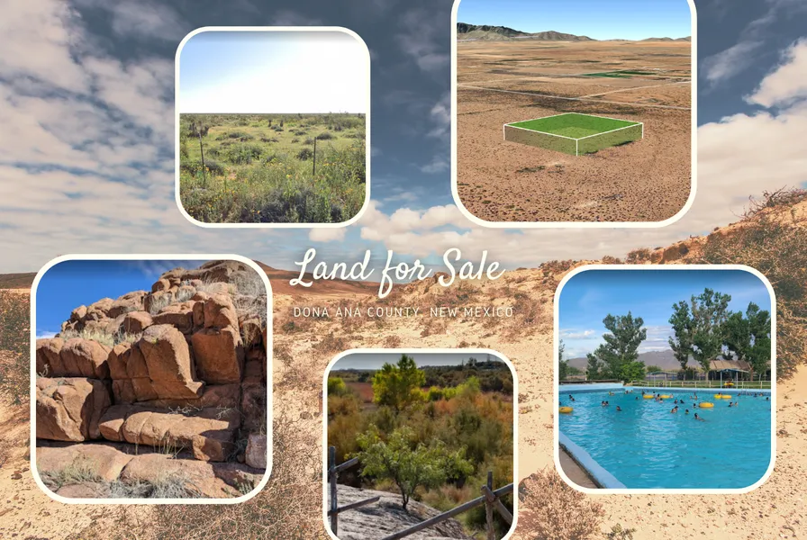
PRICE DROP!! 2.5 acres gorgeous land in Chaparral. Only $411 per month!
Easy living awaits you in this desert location in Dona Ana County, New Mexico. This property is nestled in a prime location in Chaparral offering gorgeous mountain views and open wide space. Just 44 minutes of driving northwest and you will reach the center of the town of Las Cruces and 30 minutes drive south and you will reach the city of El Paso, Texas.
Those living in New Mexico or moving to New Mexico have reasons to be happy. The states job market is looking up. Historically, though, it hasnt been very good. Wallet Hub has ranked NM 43rd for jobs. But all that is changing now.
What are you waiting for? Call us now to learn more about this offer!
Property Details:
Parcel #: 4-027-152-210-050
Property address: CHAPARRAL, NM, 88081
County: Dona Ana County
State: New Mexico
Parcel Size: 2.5 acres
Legal Description: S: 9 T: 26S R: 5E SWQTRNEQTRNEQTRNWQTR
Land Use: VACANT LAND (NEC)
Property Type: VACANT
GPS Center Coordinates: 32.0657, -106.4384
GPS Coordinates (Corners):
32.065320, -106.438966
32.066245, -106.438974
32.066255, -106.437889
32.065329, -106.437883
Tax Amount: $166.8
Disclaimer Buyer must perform their own due diligence they should do with any land purchase. This land is sold as is and all information provided is to the best of sellers knowledge. Seller does not guarantee accuracy of property location on maps or descriptions show in listing as well as facts describing the property. Buyer to verify all details of property including property location and boundaries and lot lines, as well as feasibility to use property for buyers desired purpose. Many of the pictures provided are not personally taken by the seller and some of the presented pictures represent the general area near/around the property. All utilities related to this property are potentially subject to a connection charge or additional expense to bring them to or onto the property. Furthermore, It is understood and agreed to by the parties involved that selling party, while holding an equitable interest in and to the property, is not presently making, and has not made, any representation to any party that it holds legal title in and to the property. To the fullest extent permitted by law, the Buyer hereby agrees to waive, release and forever discharge goodlanddiscounts dot com, Good American Lands, LLC and all its affiliate companies from any claim, be it at law or in equity, that the Buyer, their heirs, transferees, assigns, subrogees, devisees, and agents may allege, arising out of our disclosure(s) of its present interest in and to the property, if any as well as out of any potential and accidental discrepancies in lot lines, pictures or property location to the actual property.
From elevation to risk assessment
Search for detailed parcel information including; Elevation & Vegetation Maps, Ownership Information, Detailed Parcel Information, Crop History Map, Soil Survey Productivity Data, and more.
Research Parcel InformationEnvironmental Factors
Land for Sale by Priya Menon
Dona Ana County Properties By Type
- Undeveloped Land for Sale in Dona Ana County, New Mexico
- Farms for Sale in Dona Ana County, New Mexico
- Ranches for Sale in Dona Ana County, New Mexico
- Residential Property for Sale in Dona Ana County, New Mexico
- Commercial Property for Sale in Dona Ana County, New Mexico
- Recreational Property for Sale in Dona Ana County, New Mexico
- Horse Property for Sale in Dona Ana County, New Mexico
- Hunting Land for Sale in Dona Ana County, New Mexico
- Riverfront Property for Sale in Dona Ana County, New Mexico
- Lakefront Property for Sale in Dona Ana County, New Mexico
- Beachfront Property for Sale in Dona Ana County, New Mexico
- Timberland for Sale in Dona Ana County, New Mexico
Properties for Sale Nearby Counties
Dona Ana County Properties By City
- Anthony, New Mexico Land for Sale
- Berino, New Mexico Land for Sale
- Chamberino, New Mexico Land for Sale
- Chaparral, New Mexico Land for Sale
- Fairacres, New Mexico Land for Sale
- Garfield, New Mexico Land for Sale
- Hatch, New Mexico Land for Sale
- La Mesa, New Mexico Land for Sale
- Las Cruces, New Mexico Land for Sale
- Mesilla, New Mexico Land for Sale
- Mesilla Park, New Mexico Land for Sale
- Mesquite, New Mexico Land for Sale
- More
- Organ, New Mexico Land for Sale
- Radium Springs, New Mexico Land for Sale
- Rincon, New Mexico Land for Sale
- Salem, New Mexico Land for Sale
- San Miguel, New Mexico Land for Sale
- Santa Teresa, New Mexico Land for Sale
- Sunland Park, New Mexico Land for Sale
- Vado, New Mexico Land for Sale
- La Union, New Mexico Land for Sale
- Rodey, New Mexico Land for Sale
- Santo Tomas, New Mexico Land for Sale
- Tortugas, New Mexico Land for Sale
- White Sands, New Mexico Land for Sale
- Aden, New Mexico Land for Sale
- Afton, New Mexico Land for Sale
- Anapra, New Mexico Land for Sale
- Boyd, New Mexico Land for Sale
- Chapparal, New Mexico Land for Sale
- Chappel, New Mexico Land for Sale
- Doña Ana, New Mexico Land for Sale
- El Ojito, New Mexico Land for Sale
- Fort Selden, New Mexico Land for Sale
- Four Points, New Mexico Land for Sale
- Grama, New Mexico Land for Sale
- Hacienda Acres, New Mexico Land for Sale
- Hersey Place, New Mexico Land for Sale
- Hill, New Mexico Land for Sale
- Hockett, New Mexico Land for Sale
- Kenzin, New Mexico Land for Sale
- Kimball Place, New Mexico Land for Sale
- La Union Vieja, New Mexico Land for Sale
- Lanark, New Mexico Land for Sale
- Leasburg, New Mexico Land for Sale
- Lizard, New Mexico Land for Sale
- Malpais, New Mexico Land for Sale
- Mastodon, New Mexico Land for Sale
- Noria, New Mexico Land for Sale
- Orange, New Mexico Land for Sale
- Potrillo, New Mexico Land for Sale
- Pronto, New Mexico Land for Sale
- Rutter, New Mexico Land for Sale
- Strauss, New Mexico Land for Sale
- Tonuco, New Mexico Land for Sale
- University Park, New Mexico Land for Sale
- Vevay, New Mexico Land for Sale