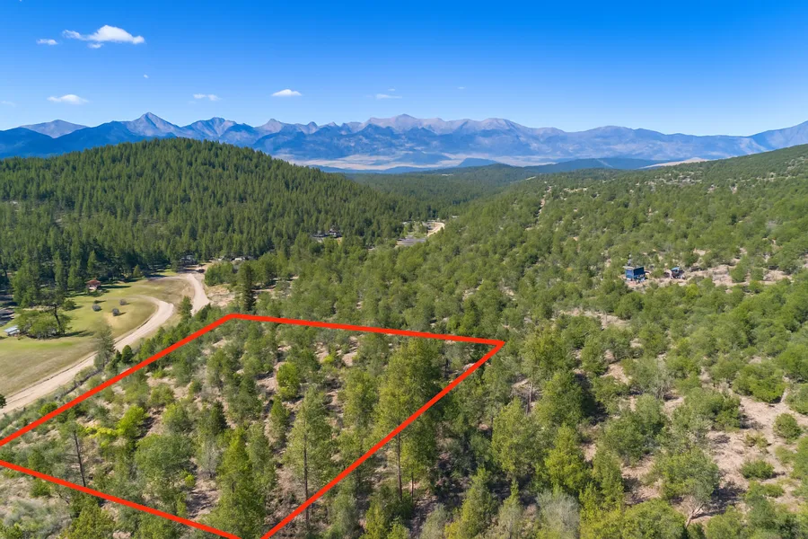
1.94 Acres With Beautiful Mountain Views! In Cotopaxi, Fremont County CO
1.94 Acres With Beautiful Mountain Views! In Cotopaxi, Fremont County CO
Discounted Cash Price: $18,999
Or Choose Your Owner Financing Plan:
$3,799 down, $429/month for 46 months
$2,849 down, $409/month for 53 months
$1,899 down, $399/month for 60 months
Do you want your own custom plan? call or text us today to discuss how much you'd like to put down.
There are NO Credit Checks. There is NO Prepayment Penalty, you can pay off the property at any time. Title
Don't miss this 1.94 Acre property in Colorado featuring beautiful mountain views & power nearby. This perfectly situated property in Teller County is ideal for a vacation destination, new home, RV while building (with permit), Site-built home, mobile & manufactured homes, investment, or retirement.
Elevation: The property elevation starts around 7,480 feet in the southeastern corner, and increases to 7,560 feet in the northwestern corner, giving the property a slope of 80 feet across the property width of 330 feet.
Property Uses: There are some neighbors that have built on or started to use their property. Some neighbor uses site-built homes.
Camping & RV: Do you want to start enjoying this property and drop your 5th wheel immediately? Go for it. RV is allowed 2 weeks/ year. RV is allowed while building with an active construction permit and need to make a legal document with planning and zoning department if we are the builders and if construction is done via other company then we cannot live in it.
Amenities: The property is located off CO - 69 (4.1 miles away). The town of Texas Creek is about 14 minutes Northwest, and Canon City is about 39 minutes Northeast. Both Texas Creek and Canon City offer you a wide range of necessities and services - including grocery stores, gas stations, Safeway, Walmart, Napa Auto Parts, pharmacies, medical clinics, and regional airports.
In the area you will have access to schools for kids of all ages, regional airports, hospitals, and medical clinics.
International Airport: You will find an international airport in Denver, 2 hours and 38 minutes from the property.
BLM Lands Nearby: You can also enjoy nearby access to over 10,000 acres of publicly accessible state trust lands and parks.
Outdoor Recreation: If you want to get out for some adventures, you can check out nearby San Isabel National Forests, or Lake Pueblo State Park. Both are within 1 hour 8 minutes drive. You'll find lots of scenic landscapes to hike through, diverse terrain, and amazing wildlife observation spots. You could also take the opportunity to fish, or go biking, Hiking, walking, camping, or do motorized and non-motorized watercraft.
You can easily secure this property today to start enjoying everything that Colorado has to offer. Call or Text us anytime to get started or learn more.
Details
Address: County Rd 28, Cotopaxi, CO 81223
Parcel Number: 76005590
Legal Description: SE1/4 NW1/4 SW1/4 NE1/4 of Section 3, Township 20 South, Range 73 West of the 6th P.M. County of Fremont, State of Colorado. also known by street and number as Vacant Land, Cotopaxi, CO 8
County: Fremont
Size: 1.94 Acre
Property Survey: No
Power: 192 feet South along the opposite side of the road CR 28 (provided by San Isabel Electric (719)-547-2160 )
Water: Would be well
Sewage: Would be septic
Phone: Cell or Satellite (coverage map)
Zoning: AE Agricultural Estates
Camping and RV: Camping No, RV is allowed 2 weeks/ year. RV is allowed while building with an active construction permit and need to make a legal document with planning and zoning department if we are the builders and if construction is done via other company then we cannot live in it.
Mobile Homes Allowed?: Yes
Manufactured Homes Allowed?: Yes
Site Built Homes Allowed?: Yes
Minimum Square Footage: 400 sq ft
HOA: None
Flood Zone: No (Refer to Land id map above)
Wetlands: No (Refer to Land id map above)
Access: Legal access only
Annual Property Taxes: $184
General Elevation: 7,565 feet
Terrain: Steep Slope Uphill
Dimensions: 325 x 261 x 330 x 260 feet
Conveyance: Warranty Deed
Title: Free and Clear
Google GPS Corner Coordinates
Nw: 38.34483, -105.527964
Ne: 38.344826, -105.526824
Sw: 38.344121, -105.527862
Se: 38.344128, -105.526714
Approximate Distance to Nearby Cities & Points of Interest
4 miles to Colorado 69
14 minutes to Texas Creek : Population 1,639
39 minutes to Canon City : Population 17,363
1 hour 18 minutes to Pueblo : Population 110,000
2 hours and 38 minutes to Denver International Airport
Points Of Interest
48 minutes to San Isabel National Forests
Activities at San Isabel National Forests: camping, fishing, bird and wildlife observation, motorized watercraft, walking/hiking trails
1 hour 8 minutes to Lake Pueblo State Park
Activities at Lake Pueblo State Park: camping, fishing, bird and wildlife observation, motorized watercraft, walking / hiking trails
Are you a fisherman?
Nearby fish includes: Smallmouth and Largemouth bass, walleye, crappies, trout, channel catfish and wipers and more.
Call or Text us anytime for questions or to learn more about how to purchase this property.
From elevation to risk assessment
Search for detailed parcel information including; Elevation & Vegetation Maps, Ownership Information, Detailed Parcel Information, Crop History Map, Soil Survey Productivity Data, and more.
Research Parcel InformationDirections
From Cotopaxi:
-Head west on Plum St toward Co Rd 12 (0.1 mi)
-Turn left onto Co Rd 12 (0.1 mi)
-Turn left onto US-50 E (7.2 mi)
-Turn right onto CO-69 S (5.0 mi)
-Turn left onto Gulch Rd
-Destination will be on the left (4.1 mi)
Resources
Land for Sale by Andrew Gaasenbeek
Fremont County Properties By Type
- Undeveloped Land for Sale in Fremont County, Colorado
- Riverfront Property for Sale in Fremont County, Colorado
- Ranches for Sale in Fremont County, Colorado
- Lakefront Property for Sale in Fremont County, Colorado
- Residential Property for Sale in Fremont County, Colorado
- Hunting Land for Sale in Fremont County, Colorado
- Farms for Sale in Fremont County, Colorado
- Commercial Property for Sale in Fremont County, Colorado
- Horse Property for Sale in Fremont County, Colorado
- Timberland for Sale in Fremont County, Colorado
- Recreational Property for Sale in Fremont County, Colorado
- Beachfront Property for Sale in Fremont County, Colorado
Properties for Sale Nearby Counties
Fremont County Properties By City
- Canon City, Colorado Land for Sale
- Coal Creek, Colorado Land for Sale
- Coaldale, Colorado Land for Sale
- Cotopaxi, Colorado Land for Sale
- Florence, Colorado Land for Sale
- Hillside, Colorado Land for Sale
- Howard, Colorado Land for Sale
- Penrose, Colorado Land for Sale
- Rockvale, Colorado Land for Sale
- Buckskin Joe, Colorado Land for Sale
- Portland, Colorado Land for Sale
- Prospect Heights, Colorado Land for Sale
- More
- Texas Creek, Colorado Land for Sale
- Williamsburg, Colorado Land for Sale
- Adelaide, Colorado Land for Sale
- Brookside, Colorado Land for Sale
- Concrete, Colorado Land for Sale
- East Canon, Colorado Land for Sale
- Echo, Colorado Land for Sale
- Fink, Colorado Land for Sale
- Galena, Colorado Land for Sale
- Lincoln Park, Colorado Land for Sale
- Orchard Park, Colorado Land for Sale
- Park Center, Colorado Land for Sale
- Pleasanton, Colorado Land for Sale
- Sample, Colorado Land for Sale
- Sikes, Colorado Land for Sale
- Sunset City, Colorado Land for Sale
- Vallie, Colorado Land for Sale
- Whitehorn, Colorado Land for Sale
- Yorkville, Colorado Land for Sale
