Phelps Branch Tract - 35 Acres
Description
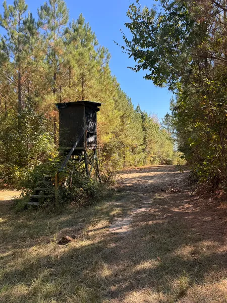
Step into the 35 Acres of the “Phelps Branch Tract”. It is located just 4.15 miles south of the charming downtown of “Cuba” Alabama; boasting 1200’ of excellent paved access on County Road 5. The topography is level with the paved road and as one travels east through the property it gently rolls a total of 30’ over ¼ mile until it reaches its lowest point of the spring-fed tributary of “Phelps Branch Bottom.” For most of the 20th century, this property was in cultivation and some livestock production; showcasing fertile soils for a high rating site-index for the planted Loblolly Pines or leaving the opportunity to convert the tract back into pasture, if desired, or further continue the develop and expand on the vast hunting potential and notable wildlife that call haven to the tract now: Bob-White Quail, Whitetail Deer & Turkey. The Loblolly Pines were planted in 2014 and quickly entering the range of minimum mill specs for return on investment. There are interspersed trails throughout from previously established logging roads and a shooting house accompanied with cultivated acreage in the South-central portion of the property. Bushels of wild muscadines and American Beautyberries are scattered throughout along with other wildlife desired flora and of course a constantly flowing and crystal clean water-source that create a staple for the ecosystem within. The property sets in a pocket of timber-focused tracts via large land owners with limited hunting pressure. Power & County Water are available on County Road 5; therefore, the opportunity to build is inevitable... grow roots here on the Phelps Branch Tract!
The property is offered as a whole or in division.
- Access: County Road 5 (1200’ – paved)
- 12-Year Old Planted Loblolly Pines: 26 Acres
- Hardwood SMZ: 9 Acres
Agent: Mack Brasher [205.495.4650]
From elevation to risk assessment
Search for detailed parcel information including; Elevation & Vegetation Maps, Ownership Information, Detailed Parcel Information, Crop History Map, Soil Survey Productivity Data, and more.
Research Parcel InformationDirections
From the Intersection of CR 5 (Brunson 5) & CR 10... traverse South on CR 5 (Brunson 5) for 0.90 Miles and the property entrance will be on the east side of CR 5 (Brunson 5)
Environmental Factors
Sumter County Properties By Type
- Hunting Land for Sale in Sumter County, Alabama
- Farms for Sale in Sumter County, Alabama
- Recreational Property for Sale in Sumter County, Alabama
- Timberland for Sale in Sumter County, Alabama
- Riverfront Property for Sale in Sumter County, Alabama
- Lakefront Property for Sale in Sumter County, Alabama
- Residential Property for Sale in Sumter County, Alabama
- Undeveloped Land for Sale in Sumter County, Alabama
- Commercial Property for Sale in Sumter County, Alabama
- Ranches for Sale in Sumter County, Alabama
- Horse Property for Sale in Sumter County, Alabama
- Beachfront Property for Sale in Sumter County, Alabama
Properties for Sale Nearby Counties
Sumter County Properties By City
- Bellamy, Alabama Land for Sale
- Cuba, Alabama Land for Sale
- Emelle, Alabama Land for Sale
- Epes, Alabama Land for Sale
- Gainesville, Alabama Land for Sale
- Livingston, Alabama Land for Sale
- Panola, Alabama Land for Sale
- York, Alabama Land for Sale
- Coatopa, Alabama Land for Sale
- Geiger, Alabama Land for Sale
- Sumterville, Alabama Land for Sale
- Whitfield, Alabama Land for Sale
- More
- Bluffport, Alabama Land for Sale
- Boyd, Alabama Land for Sale
- Brewersville, Alabama Land for Sale
- Brownstown, Alabama Land for Sale
- Charles, Alabama Land for Sale
- Derby, Alabama Land for Sale
- Dove, Alabama Land for Sale
- Dug Hill, Alabama Land for Sale
- Fair Oaks, Alabama Land for Sale
- Gaston, Alabama Land for Sale
- Hall Creek, Alabama Land for Sale
- Hamner, Alabama Land for Sale
- Hixon, Alabama Land for Sale
- Intercourse, Alabama Land for Sale
- Kinterbish, Alabama Land for Sale
- Lilita, Alabama Land for Sale
- McCainville, Alabama Land for Sale
- McDowell, Alabama Land for Sale
- Millville, Alabama Land for Sale
- Moore Town, Alabama Land for Sale
- Old Bluffport, Alabama Land for Sale
- Payneville, Alabama Land for Sale
- Scratch Hill, Alabama Land for Sale
- Siloam, Alabama Land for Sale
- Sledge, Alabama Land for Sale
- Standard, Alabama Land for Sale
- Warsaw, Alabama Land for Sale
- Williams, Alabama Land for Sale
- Woodford, Alabama Land for Sale
- Zion Hill, Alabama Land for Sale