SPACIOUS VIEWS ON 40 ACRES IN NORTHERN ARIZONA
Just $1,000 Down! Located between Chambers and St Johns area of Northern Arizona, this expansive property offers spacious views, vibrant vegetation, and great access so you can quickly set up your off-grid life.
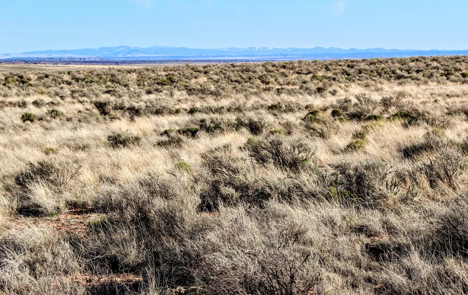
The terrain is mostly level, giving several areas that would be ideal for building. Wide-open space to ride horses or UTVs, you can play while you build with nothing to obstruct your views. This property is remote with a few neighbors nearby so you have seclusion but not complete isolation. With the convenience of access to I-40 (Historic Route 66) and US-191, you can enjoy the peace of homesteading and quickly be on the road for all of your outdoor adventures. A little trip to Witch Well Tavern and With Wells Farmers Market & Swap Meet, you can shop the market and try out some local eats. Close to Chambers, you can make a quick drive for some small town charm or to pick up the basics.
This property has NO owners association nor covenants.
-No restrictions on dwelling size.
-You can build anything for residential purposes such as Single Family, Mobile or Manufactured home.
-Camping & RVs are okay as well (permits required for long-term stay, more than 30 days).
Visiting the Property: We are not real estate agents and we actually own the properties we have for sale. We run a self-service setup which means you are welcome to go view the property on your schedule and at your leisure. We only ask that you do so during daylight hours. We have provided everything you need in the listing, including GPS coordinates of the four corners of the property and a Google Maps link so you can plug in directions to take you right to the property. Land id (formerly MapRight) is a great tool we provide to help you locate and walk the property. Its free to download and you dont need to register. When youre ready to visit the property, contact us and we will share the property map with you directly.
Access to the property is via CR7002 to an unmarked road, south from I-40 (Historic Route 66) or west from US-191. See the map photos for details on directions.
I have included a complete set of ACTUAL property photos all boundary outlines in footage are approximate. I have not visited this property and have included everything I know about it below.
WHATS CLOSE?
27 miles to Navajo Travel Center, Dollar General & Post Office in Chambers
32 miles to Witch Well Store, Witch Wells Farmers Market & Swap Meet
35 miles to Petrified Forest National Park & Painted Desert
1 hour & 5 minutes to KOA in Holbrook
2.5 hours to Walmart in Snowflake/Taylor area & Flagstaff
3 hours to Sedona a
3.5 hours to Albuquerque
4.5 hours to Phoenix
PROPERTY DETAILS
Size (Acres): 40.00 +/-
General Location: CR7002, Chambers, AZ 86502
APN or Other ID: 206-78-006
Subdivision: N/A
Legal Description: The SE 1/4 of NW 1/4 of Section 33, Township 18 North, Range 26 East, Apache County, Arizona
Approx. GPS:
34.9192, -109.5914
34.9192, -109.587
34.915583, -109.587000
34.9156, -109.5914
Property Type: Rural Land
Land Use: Houses, tiny homes, THOWs, RVs, travel trailers, vanlife, camping, recreational uses, agricultural uses
Zoning: General Agricultural. For more information, contact Apache County 928-337-7526 or visit their website
HOA/POA Fees: No
Terrain: Varied
General Elevation: Approx. 5,900
Power: Would be by generator, solar or wind
Phone: Mobile/Satellite/Alternative
Water: Would need to drill well or use alternative system
Sewer: Would need septic or alternative system
Roads: Dirt, 4WD Recommended
Title Info: Clear Title, Conveyed from LG Solutions LLC
Annual Property Taxes: Approx. $68
Doc Fee: Terms $499, Cash Responsibility of Buyer (To be closed through Pioneer Title)
From elevation to risk assessment
Search for detailed parcel information including; Elevation & Vegetation Maps, Ownership Information, Detailed Parcel Information, Crop History Map, Soil Survey Productivity Data, and more.
Research Parcel InformationDirections
Visiting the Property: We are not real estate agents and we actually own the properties we have for sale. We run a self-service setup which means you are welcome to go view the property on your schedule and at your leisure. We only ask that you do so during daylight hours. We have provided everything you need in the listing, including GPS coordinates of the four corners of the property and a Google Maps link so you can plug in directions to take you right to the property. Land id (formerly MapRight) is a great tool we provide to help you locate and walk the property. Its free to download and you dont need to register. When youre ready to visit the property, contact us and we will share the property map with you directly.
Access to the property is via CR7002 to an unmarked road, south from I-40 (Historic Route 66) or west from US-191. See the map photos for details on directions.
Environmental Factors
Land for Sale by Dave Ayres
Apache County Properties By Type
- Undeveloped Land for Sale in Apache County, Arizona
- Residential Property for Sale in Apache County, Arizona
- Farms for Sale in Apache County, Arizona
- Recreational Property for Sale in Apache County, Arizona
- Ranches for Sale in Apache County, Arizona
- Lakefront Property for Sale in Apache County, Arizona
- Riverfront Property for Sale in Apache County, Arizona
- Beachfront Property for Sale in Apache County, Arizona
- Hunting Land for Sale in Apache County, Arizona
- Commercial Property for Sale in Apache County, Arizona
- Timberland for Sale in Apache County, Arizona
- Horse Property for Sale in Apache County, Arizona
Properties for Sale Nearby Counties
- Catron County, Arizona Land for Sale
- Cibola County, Arizona Land for Sale
- Graham County, Arizona Land for Sale
- Greenlee County, Arizona Land for Sale
- McKinley County, Arizona Land for Sale
- Montezuma County, Arizona Land for Sale
- Navajo County, Arizona Land for Sale
- San Juan County, Arizona Land for Sale
- San Juan County, Arizona Land for Sale
Apache County Properties By City
- Alpine, Arizona Land for Sale
- Chambers, Arizona Land for Sale
- Chinle, Arizona Land for Sale
- Concho, Arizona Land for Sale
- Dennehotso, Arizona Land for Sale
- Eagar, Arizona Land for Sale
- Fort Defiance, Arizona Land for Sale
- Ganado, Arizona Land for Sale
- Greer, Arizona Land for Sale
- Houck, Arizona Land for Sale
- Lukachukai, Arizona Land for Sale
- Lupton, Arizona Land for Sale
- More
- Many Farms, Arizona Land for Sale
- Mcnary, Arizona Land for Sale
- Nazlini, Arizona Land for Sale
- Nutrioso, Arizona Land for Sale
- Rock Point, Arizona Land for Sale
- Round Rock, Arizona Land for Sale
- Saint Johns, Arizona Land for Sale
- Saint Michaels, Arizona Land for Sale
- Sanders, Arizona Land for Sale
- Springerville, Arizona Land for Sale
- Teec Nos Pos, Arizona Land for Sale
- Vernon, Arizona Land for Sale
- Window Rock, Arizona Land for Sale
- Concho Valley, Arizona Land for Sale
- Cornfields, Arizona Land for Sale
- Greasewood, Arizona Land for Sale
- Klagetoh, Arizona Land for Sale
- Mexican Water, Arizona Land for Sale
- Red Mesa, Arizona Land for Sale
- Richville, Arizona Land for Sale
- Rough Rock, Arizona Land for Sale
- Salado, Arizona Land for Sale
- Salina, Arizona Land for Sale
- Steamboat Canyon, Arizona Land for Sale
- Sunrise Springs, Arizona Land for Sale
- Tahchee, Arizona Land for Sale
- Toyei, Arizona Land for Sale
- Adamana, Arizona Land for Sale
- Allentown, Arizona Land for Sale
- Boneyard, Arizona Land for Sale
- Bonita Trading Post, Arizona Land for Sale
- Burnside, Arizona Land for Sale
- Chetco, Arizona Land for Sale
- Correjo Crossing, Arizona Land for Sale
- Cove, Arizona Land for Sale
- Coyote Springs, Arizona Land for Sale
- Crosby Crossing, Arizona Land for Sale
- Del Muerto, Arizona Land for Sale
- Diamond Fields, Arizona Land for Sale
- El Tule, Arizona Land for Sale
- Emmanuel Mission, Arizona Land for Sale
- Feaster, Arizona Land for Sale
- Flat Rock, Arizona Land for Sale
- Green Spot, Arizona Land for Sale
- Greer Place, Arizona Land for Sale
- Hawley Lake, Arizona Land for Sale
- Heap Place, Arizona Land for Sale
- Hunt, Arizona Land for Sale
- Hunters Point, Arizona Land for Sale
- Junction Overlook, Arizona Land for Sale
- Kinlichee, Arizona Land for Sale
- Kinney Junction, Arizona Land for Sale
- Los Burros, Arizona Land for Sale
- Lower Wheatfields, Arizona Land for Sale
- Maverick, Arizona Land for Sale
- Mexican Water Trading Post, Arizona Land for Sale
- Milkwater, Arizona Land for Sale
- Navajo, Arizona Land for Sale
- Northwoods, Arizona Land for Sale
- Oak Springs, Arizona Land for Sale
- Paulcell Place, Arizona Land for Sale
- Pine Springs, Arizona Land for Sale
- Pinta, Arizona Land for Sale
- Potter Place, Arizona Land for Sale
- Rosebud, Arizona Land for Sale
- Sand Springs, Arizona Land for Sale
- Sehili, Arizona Land for Sale
- Steamboat, Arizona Land for Sale
- Tanner Springs, Arizona Land for Sale
- Tes Nez Iah, Arizona Land for Sale
- Three Forks, Arizona Land for Sale
- Totacon, Arizona Land for Sale
- Troweek, Arizona Land for Sale
- Tsintaa Yiti Ii, Arizona Land for Sale
- Twin Falls, Arizona Land for Sale
- Upper Wheatfields, Arizona Land for Sale
- Wheatfields, Arizona Land for Sale
- White Clay, Arizona Land for Sale
- Wide Ruins, Arizona Land for Sale
- Wood Springs, Arizona Land for Sale
- Woodspring Trading Post, Arizona Land for Sale
- Yazzi, Arizona Land for Sale