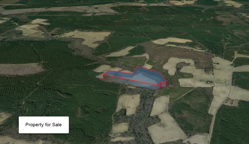
A Generous 32.9-Acre Rough Diamond in Dinwiddie County, VA!
Seclude yourself in the quiet tree lines with front-row seats to the verdant landscape of Dinwiddie County, Virginia. Cozily snuggled along Walkers Mill Rd, this property enjoys its soothing surroundings and the luxury of the easy road access. Relieve yourself of your everyday troubles and just listen to the chirping birds in the dense groves of trees nearby.
For your restocking needs, downtown Petersburg is 33 minutes north of your property. Picture yourself savoring a mouthwatering meal, a special glass of wine, or a cold brew while watching a breathtaking sunset from the shores of the Appomattox or James Rivers. How about singing along at that lively concert or being inspired by a work of art. Or maybe feeling the adrenaline rush that comes with your bike leaping over the trail, or the race car speeding by at 200mph, or flying across a zip line, or shooting the rapids in a kayak.
All these and more! Call us today!
Better Land Co Listing Attributes:
Cash Price: $79,000
Owner Finance Terms: $27,000 down, $700/month for 180 months
County, Dinwiddie County, VA
Acres: 32.9 Acres
GPS Coordinates: 36.970541, -77.519605
GPS Coordinates (Corners):
36.968860, -77.518070 36.971652, -77.518055
36.970654, -77.523654 36.971172, -77.517401
36.971509, -77.523144 36.971024, -77.517277
36.970911, -77.520451 36.970786, -77.517182
36.972587, -77.519933 36.970501, -77.517163
36.972348, -77.519488 36.969900, -77.516899
36.972359, -77.519380 36.969730, -77.516853
36.972302, -77.519228 36.969502, -77.516876
36.972106, -77.518905 36.969380, -77.517034
36.971961, -77.518823 36.969388, -77.517298
36.971833, -77.518788 36.969316, -77.517462
36.971759, -77.518692 36.969185, -77.517515
36.971683, -77.518375 36.969025, -77.517662
36.968850, -77.518064
Parcel Number: 85-1-B
Yearly Taxes: $259.91
Legal Description: WALKERS MILL ROAD PARCEL B DB287/217 85-(1)-B
Elevation: 137.8 FT
Information and photos are deemed reliable, but not guaranteed. No representations as to fitness for a particular purpose have been made. No verbal claims or promises have been made to Buyer. Buyer is not relying on Seller as to the condition of the property. Buyer acknowledges that the Property is acceptable to them in its presently existing condition. Buyer to rely on its own due diligence. All sales are final.
From elevation to risk assessment
Search for detailed parcel information including; Elevation & Vegetation Maps, Ownership Information, Detailed Parcel Information, Crop History Map, Soil Survey Productivity Data, and more.
Research Parcel InformationResources
Land for Sale by Benjamin Harris
Dinwiddie County Properties By Type
- Undeveloped Land for Sale in Dinwiddie County, Virginia
- Farms for Sale in Dinwiddie County, Virginia
- Hunting Land for Sale in Dinwiddie County, Virginia
- Residential Property for Sale in Dinwiddie County, Virginia
- Ranches for Sale in Dinwiddie County, Virginia
- Lakefront Property for Sale in Dinwiddie County, Virginia
- Timberland for Sale in Dinwiddie County, Virginia
- Riverfront Property for Sale in Dinwiddie County, Virginia
- Commercial Property for Sale in Dinwiddie County, Virginia
- Recreational Property for Sale in Dinwiddie County, Virginia
- Horse Property for Sale in Dinwiddie County, Virginia
- Beachfront Property for Sale in Dinwiddie County, Virginia
Properties for Sale Nearby Counties
- Amelia County, Virginia Land for Sale
- Brunswick County, Virginia Land for Sale
- Chesterfield County, Virginia Land for Sale
- Greensville County, Virginia Land for Sale
- Nottoway County, Virginia Land for Sale
- Petersburg City County, Virginia Land for Sale
- Prince George County, Virginia Land for Sale
- Sussex County, Virginia Land for Sale
Dinwiddie County Properties By City
- Ammon, Virginia Land for Sale
- Carson, Virginia Land for Sale
- Dewitt, Virginia Land for Sale
- Dinwiddie, Virginia Land for Sale
- Sutherland, Virginia Land for Sale
- Wilsons, Virginia Land for Sale
- Mckenney, Virginia Land for Sale
- Addison, Virginia Land for Sale
- Ashley, Virginia Land for Sale
- Baltimore Corner, Virginia Land for Sale
- Baskerville Mill, Virginia Land for Sale
- Bonneville, Virginia Land for Sale
- More
- Butterworth, Virginia Land for Sale
- Champ, Virginia Land for Sale
- Chesdin Manor, Virginia Land for Sale
- Chestnut Gardens, Virginia Land for Sale
- Confederate Woods, Virginia Land for Sale
- Darvills, Virginia Land for Sale
- Dinwiddie Acres, Virginia Land for Sale
- Dinwiddie Gardens, Virginia Land for Sale
- Edge Hill Park, Virginia Land for Sale
- Ferndale Gardens, Virginia Land for Sale
- Ferndale Park, Virginia Land for Sale
- Ford, Virginia Land for Sale
- Grant Village, Virginia Land for Sale
- Harpers, Virginia Land for Sale
- Hebron, Virginia Land for Sale
- Jack, Virginia Land for Sale
- Maitland Village, Virginia Land for Sale
- Mansfield, Virginia Land for Sale
- Marmona, Virginia Land for Sale
- Mount Olivet, Virginia Land for Sale
- Oakhill, Virginia Land for Sale
- Reams, Virginia Land for Sale
- Rohoic Farms, Virginia Land for Sale
- Rowanta, Virginia Land for Sale
- Stony Springs, Virginia Land for Sale
- Sutherland Manor, Virginia Land for Sale
- Sysonby Ridge, Virginia Land for Sale
- Truit, Virginia Land for Sale
- Walkers, Virginia Land for Sale
- Warrington Heights, Virginia Land for Sale
- West Petersburg, Virginia Land for Sale
- Winfields Mill, Virginia Land for Sale