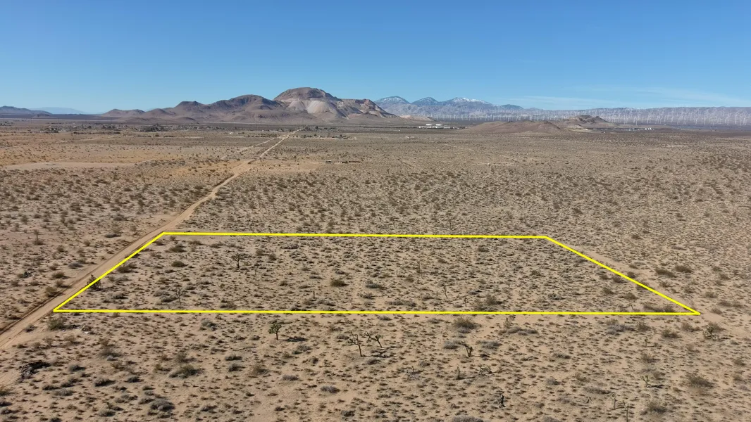
2.5 Acres located in Mojave
2.5 Acres located in Mojave, between Hwy 58 and 14, below Mojave Air & Space Port and Airplane Graveyard Viewpoint, zoned Limited Agriculture.
Discounted CASH Price $12,500
Owner Financing Available with $0 upfront and $400 doc fee
$317 x 48 months
APN: 429-151-07-00-7
Property City: MOJAVE
Property State: CA
Property Zip Code: 93501
Township: 10N
Section: 12
Legal Description: PTN OF NW1/4 SEC12 T10 R12 EXC SODIUM & P
Tax Amount: $51.17/ CURRENT :_)
Zoning: A-1- Limited Agriculture
Acres: 2.5
Land Square Footage: 108900
COORDINATES:
34.9803957034733,-118.106793557473
;34.9822208724605,-118.106803679035
;34.9822049376281,-118.107364917547
;34.9812925373857,-118.10735958023
;34.9803800747474,-118.10735424295
;34.9803957034733,-118.106793557473
ATTRIBUTES:
* zoned Agricultural
* very close to Hwy 58 and 14
* Permitted Uses:
Single family residences, crops (field, tree, bush, berry, row and nursery stock
Greenhouses and raising of cattle, horses, sheep, goats, poultry, birds, earthworms, etc.
All information we have on this property is disclosed within the content of the listing page.
Any and all other information on this property should be directed toward the city or county of which the property is located in.
Your due diligence should be performed, to ensure the property meets your needs and criteria.
About the Seller:
We are a husband and wife who love to invest in land.
We review thousands of properties for everyone that we buy in order to bring you the BEST deal possible.
The pricing we get them at is reflected in the pricing of what I am selling them for. They are priced at half the current market price or less TO SELL.
Because of their price they dont usually stay for sale for very long.
The buyer is responsible for learning all the restrictions from the county/ township/ planning and zoning office.
What you can or cannot legally do on the land is controlled by the local government, not by us or any seller.
Please contact the county, providing them with the parcel number, to confirm zoning, access, and available utilities.
Thank you for searching and taking interest in our land!
Patrycja & Tom with Land Addiction
If you have any questions, TEXT Patricia: 773-398-8027
From elevation to risk assessment
Search for detailed parcel information including; Elevation & Vegetation Maps, Ownership Information, Detailed Parcel Information, Crop History Map, Soil Survey Productivity Data, and more.
Research Parcel InformationDirections
COORDINATES:
34.9803957034733,-118.106793557473
;34.9822208724605,-118.106803679035
;34.9822049376281,-118.107364917547
;34.9812925373857,-118.10735958023
;34.9803800747474,-118.10735424295
;34.9803957034733,-118.106793557473
Google Map:
https://goo.gl/maps/yiXtuW72TF54TEGh6
Drone Video:
https://youtu.be/8IYqq7KcVo4
https://youtu.be/8IYqq7KcVo4
Resources
Land for Sale by Patrycja Zak
Kern County Properties By Type
- Farms for Sale in Kern County, California
- Undeveloped Land for Sale in Kern County, California
- Ranches for Sale in Kern County, California
- Residential Property for Sale in Kern County, California
- Riverfront Property for Sale in Kern County, California
- Commercial Property for Sale in Kern County, California
- Recreational Property for Sale in Kern County, California
- Lakefront Property for Sale in Kern County, California
- Horse Property for Sale in Kern County, California
- Hunting Land for Sale in Kern County, California
- Beachfront Property for Sale in Kern County, California
- Timberland for Sale in Kern County, California
Properties for Sale Nearby Counties
- Inyo County, California Land for Sale
- Kings County, California Land for Sale
- Los Angeles County, California Land for Sale
- San Bernardino County, California Land for Sale
- San Luis Obispo County, California Land for Sale
- Santa Barbara County, California Land for Sale
- Tulare County, California Land for Sale
- Ventura County, California Land for Sale
Kern County Properties By City
- Arvin, California Land for Sale
- Bakersfield, California Land for Sale
- Bodfish, California Land for Sale
- Boron, California Land for Sale
- Buttonwillow, California Land for Sale
- Caliente, California Land for Sale
- California City, California Land for Sale
- Cantil, California Land for Sale
- Delano, California Land for Sale
- Edison, California Land for Sale
- Edwards, California Land for Sale
- Fellows, California Land for Sale
- More
- Frazier Park, California Land for Sale
- Glennville, California Land for Sale
- Inyokern, California Land for Sale
- Johannesburg, California Land for Sale
- Keene, California Land for Sale
- Kernville, California Land for Sale
- Lake Isabella, California Land for Sale
- Lamont, California Land for Sale
- Lebec, California Land for Sale
- Lost Hills, California Land for Sale
- Maricopa, California Land for Sale
- Mojave, California Land for Sale
- Onyx, California Land for Sale
- Randsburg, California Land for Sale
- Red Mountain, California Land for Sale
- Ridgecrest, California Land for Sale
- Rosamond, California Land for Sale
- Shafter, California Land for Sale
- Taft, California Land for Sale
- Tehachapi, California Land for Sale
- Tupman, California Land for Sale
- Wasco, California Land for Sale
- Weldon, California Land for Sale
- Wofford Heights, California Land for Sale
- Woody, California Land for Sale
- Aerial Acres, California Land for Sale
- Bear Valley Springs, California Land for Sale
- China Lake, California Land for Sale
- Desert Lake, California Land for Sale
- Di Giorgio, California Land for Sale
- Golden Hills, California Land for Sale
- Gorman, California Land for Sale
- Havilah, California Land for Sale
- Loraine, California Land for Sale
- Mettler, California Land for Sale
- Monolith, California Land for Sale
- Mountain Mesa, California Land for Sale
- North Edwards, California Land for Sale
- Pearsonville, California Land for Sale
- Pine Mountain Club, California Land for Sale
- Pumpkin Center, California Land for Sale
- Sand Canyon, California Land for Sale
- Stallion Springs, California Land for Sale
- Willow Springs, California Land for Sale
- Actis, California Land for Sale
- Algoso, California Land for Sale
- Annette, California Land for Sale
- Ansel, California Land for Sale
- Armistead, California Land for Sale
- Bannister, California Land for Sale
- Bealville, California Land for Sale
- Bena, California Land for Sale
- Bissell, California Land for Sale
- Blackwells Corner, California Land for Sale
- Bowerbank, California Land for Sale
- Bradys, California Land for Sale
- Brown, California Land for Sale
- Burton Mill, California Land for Sale
- Cable, California Land for Sale
- Calders Corner, California Land for Sale
- Camp Owens, California Land for Sale
- Cawelo, California Land for Sale
- Ceneda, California Land for Sale
- Chaffee, California Land for Sale
- Cherokee Strip, California Land for Sale
- China Lake Acres, California Land for Sale
- Cinco, California Land for Sale
- Claraville, California Land for Sale
- Conner, California Land for Sale
- Crome, California Land for Sale
- Derby Acres, California Land for Sale
- Dow, California Land for Sale
- Dustin Acres, California Land for Sale
- East Bakersfield, California Land for Sale
- Edmundson Acres, California Land for Sale
- El Rita, California Land for Sale
- Elmo, California Land for Sale
- Famoso, California Land for Sale
- Fig Orchard, California Land for Sale
- Fleta, California Land for Sale
- Ford City, California Land for Sale
- Fruitvale, California Land for Sale
- Fuller Acres, California Land for Sale
- Garlock, California Land for Sale
- Gloster, California Land for Sale
- Goler Heights, California Land for Sale
- Gosford, California Land for Sale
- Grapevine, California Land for Sale
- Greenacres, California Land for Sale
- Gulf, California Land for Sale
- Gypsite, California Land for Sale
- Halfway House, California Land for Sale
- Harpertown, California Land for Sale
- Harts Place, California Land for Sale
- Hazelton, California Land for Sale
- Hights Corner, California Land for Sale
- Hollis, California Land for Sale
- Ilmon, California Land for Sale
- Jasmin, California Land for Sale
- Jastro, California Land for Sale
- Kayandee, California Land for Sale
- Kecks Corner, California Land for Sale
- Kern, California Land for Sale
- Kern City, California Land for Sale
- Kern Lake, California Land for Sale
- Kernell, California Land for Sale
- Keyesville, California Land for Sale
- Kilowatt, California Land for Sale
- Lackey Place, California Land for Sale
- Lake of the Woods, California Land for Sale
- Landco, California Land for Sale
- Lerdo, California Land for Sale
- Lokern, California Land for Sale
- Lonsmith, California Land for Sale
- Magunden, California Land for Sale
- Maltha, California Land for Sale
- Manolith, California Land for Sale
- Marcel, California Land for Sale
- McFarland, California Land for Sale
- McKittrick, California Land for Sale
- Mexican Colony, California Land for Sale
- Midoil, California Land for Sale
- Millersville, California Land for Sale
- Millux, California Land for Sale
- Minter Village, California Land for Sale
- Miracle Hot Springs, California Land for Sale
- Missouri Triangle, California Land for Sale
- Mitchells Corner, California Land for Sale
- Moreland Mill, California Land for Sale
- Myricks Corner, California Land for Sale
- Neufeld, California Land for Sale
- North Belridge, California Land for Sale
- North Shafter, California Land for Sale
- Oil City, California Land for Sale
- Oil Junction, California Land for Sale
- Oildale, California Land for Sale
- Old Fort Tejon, California Land for Sale
- Old Garlock, California Land for Sale
- Old River, California Land for Sale
- Palmo, California Land for Sale
- Panama, California Land for Sale
- Patch, California Land for Sale
- Pentland, California Land for Sale
- Pettit Place, California Land for Sale
- Pond, California Land for Sale
- Prospero, California Land for Sale
- Quailwood, California Land for Sale
- Quality, California Land for Sale
- Rancho Seco, California Land for Sale
- Rand, California Land for Sale
- Reward, California Land for Sale
- Ribier, California Land for Sale
- Ricardo, California Land for Sale
- Rich, California Land for Sale
- Rio Bravo, California Land for Sale
- Riverkern, California Land for Sale
- Rosedale, California Land for Sale
- Rowen, California Land for Sale
- Saco, California Land for Sale
- Sageland, California Land for Sale
- Saltdale, California Land for Sale
- San Emidio, California Land for Sale
- Sanborn, California Land for Sale
- Searles, California Land for Sale
- Seguro, California Land for Sale
- Semitropic, California Land for Sale
- Shirley Meadows, California Land for Sale
- Silt, California Land for Sale
- Slater, California Land for Sale
- Smith Corner, California Land for Sale
- South Lake, California Land for Sale
- South Taft, California Land for Sale
- Spellacy, California Land for Sale
- Spicer City, California Land for Sale
- Squirrel Mountain Valley, California Land for Sale
- Stevens, California Land for Sale
- Summit, California Land for Sale
- Taft Heights, California Land for Sale
- Thomas Lane, California Land for Sale
- Una, California Land for Sale
- Valley Acres, California Land for Sale
- Venola, California Land for Sale
- Vinland, California Land for Sale
- Wallace Center, California Land for Sale
- Walong, California Land for Sale
- Weedpatch, California Land for Sale
- Wheeler Ridge, California Land for Sale
- Wherry Housing, California Land for Sale
- Wible Orchard, California Land for Sale
- Woodford, California Land for Sale
- Zentner, California Land for Sale