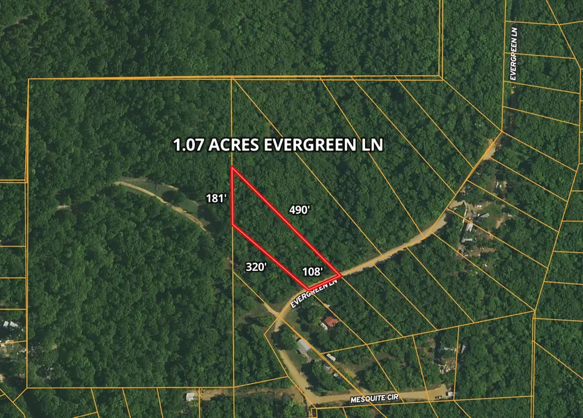
1.07 Acres Evergreen Ln, Mead, OK
Owner financing available for all! Finance this property for as little as $400 down and $400 a month. Check our website for additional term options.
An amazing opportunity to own 1.07 right next to Lake Texoma. Enjoy owning land with almost no restrictions. This property is zoned residential and allows you to build the home of your dreams. Manufactured, modular, and mobile homes are also allowed.
Located conveniently 2 hours from OKC and 1.5 hours from Dallas TX, this property allows easy access to two major cities. The nearby city of Durant is growing rapidly allowing you quick access to shopping. With the growth in the area, this property will continue to appreciate. Don't miss out on this exceptional opportunity, whether designing your new dream home, or purchasing for a savvy investment contact us today!
APN: 0280-00-001-294-0-000-00
Address: Evergreen Ln, Mead, OK 73449
County: Bryan
State: Oklahoma
Size: 1.07 Acres
Dimensions: 108 x 320 x 181 x 490
Legal: LOT 294, LAKEWOOD RANCHETTES SUBDIVISION, SECTION B, Bryan County,
Oklahoma.
Terrain: Flat
Access: Dirt/Gravel roads
Power: At the Property
Water: At the Property
Sewer: Septic Tank is Required
Taxes per Year: $13
HOA Fees per Year: $0
GPS Coordinates (center) at the road: 34.0426, -96.5463
Northwest Corner: 34.0436, -96.5472
Northeast Corner: 34.0427, -96.5461
Southwest Corner: 34.0431, -965472
Southeast Corner: 34.0425, -96.5465
Elevation: 730
BUILDING INFORMATION
Zoning: Residential
Time Limit to Build: No time limit to build
Site Built Homes Allowed: Allowed
Modular Homes Allowed: Allowed
Manufactured Homes Allowed: Allowed
Mobile Homes Allowed: Allowed
Tiny Homes Friendly: Allowed
ALLOWABLE USES
Full-Time RV Living Allowed: Allowed
RV on the Property While you build: Allowed
Camping in a RV: Allowed
County Contact Information: Call Bryan County Building Dept. (580) 931-6600
From elevation to risk assessment
Search for detailed parcel information including; Elevation & Vegetation Maps, Ownership Information, Detailed Parcel Information, Crop History Map, Soil Survey Productivity Data, and more.
Research Parcel InformationDirections
GPS Coordinates (center) at the road: 34.0426, -96.5463
Northwest Corner: 34.0436, -96.5472
Northeast Corner: 34.0427, -96.5461
Southwest Corner: 34.0431, -965472
Southeast Corner: 34.0425, -96.5465
Resources
Land for Sale by Bubba
Bryan County Properties By Type
- Undeveloped Land for Sale in Bryan County, Oklahoma
- Ranches for Sale in Bryan County, Oklahoma
- Farms for Sale in Bryan County, Oklahoma
- Riverfront Property for Sale in Bryan County, Oklahoma
- Commercial Property for Sale in Bryan County, Oklahoma
- Residential Property for Sale in Bryan County, Oklahoma
- Lakefront Property for Sale in Bryan County, Oklahoma
- Beachfront Property for Sale in Bryan County, Oklahoma
- Recreational Property for Sale in Bryan County, Oklahoma
- Hunting Land for Sale in Bryan County, Oklahoma
- Horse Property for Sale in Bryan County, Oklahoma
- Timberland for Sale in Bryan County, Oklahoma
Properties for Sale Nearby Counties
Bryan County Properties By City
- Achille, Oklahoma Land for Sale
- Albany, Oklahoma Land for Sale
- Bennington, Oklahoma Land for Sale
- Bokchito, Oklahoma Land for Sale
- Caddo, Oklahoma Land for Sale
- Calera, Oklahoma Land for Sale
- Cartwright, Oklahoma Land for Sale
- Colbert, Oklahoma Land for Sale
- Durant, Oklahoma Land for Sale
- Hendrix, Oklahoma Land for Sale
- Kemp, Oklahoma Land for Sale
- Mead, Oklahoma Land for Sale
- More
- Platter, Oklahoma Land for Sale
- Wade, Oklahoma Land for Sale
- Yarnaby, Oklahoma Land for Sale
- Allison, Oklahoma Land for Sale
- Armstrong, Oklahoma Land for Sale
- Banty, Oklahoma Land for Sale
- Blue, Oklahoma Land for Sale
- Brown, Oklahoma Land for Sale
- Cade, Oklahoma Land for Sale
- Cobb, Oklahoma Land for Sale
- Fort Washita, Oklahoma Land for Sale
- Karma, Oklahoma Land for Sale
- Kiersey, Oklahoma Land for Sale
- Lake West, Oklahoma Land for Sale
- Lakeside, Oklahoma Land for Sale
- Lee Heights, Oklahoma Land for Sale
- Matoy, Oklahoma Land for Sale
- Oberlin, Oklahoma Land for Sale
- Old Allison, Oklahoma Land for Sale
- Old Bennington, Oklahoma Land for Sale
- Olive, Oklahoma Land for Sale
- Pickwick, Oklahoma Land for Sale
- Pirtle, Oklahoma Land for Sale
- Pritchard, Oklahoma Land for Sale
- Roberta, Oklahoma Land for Sale
- Romia, Oklahoma Land for Sale
- Sand Point, Oklahoma Land for Sale
- Sevenmile Corner, Oklahoma Land for Sale
- Silo, Oklahoma Land for Sale
- Smith-Lee, Oklahoma Land for Sale
- Staley, Oklahoma Land for Sale
- Ury, Oklahoma Land for Sale
- Utica, Oklahoma Land for Sale
- Wasseta, Oklahoma Land for Sale
- Weeks, Oklahoma Land for Sale
- Yuba, Oklahoma Land for Sale