Views of the California Hills Easy Terms 10 Acres
Owner Financing available as low as $582/month!
10 acres consisting of 4 separate parcels with road access on the north and south side! Setup on either side or both. Great views of the California hills from the middle of this land. Forest Rte 29S02 cuts through the northern portion of the land and rides along the southern border as well. You are halfway between town of Caliente (9 Miles) and Claraville (5 miles).
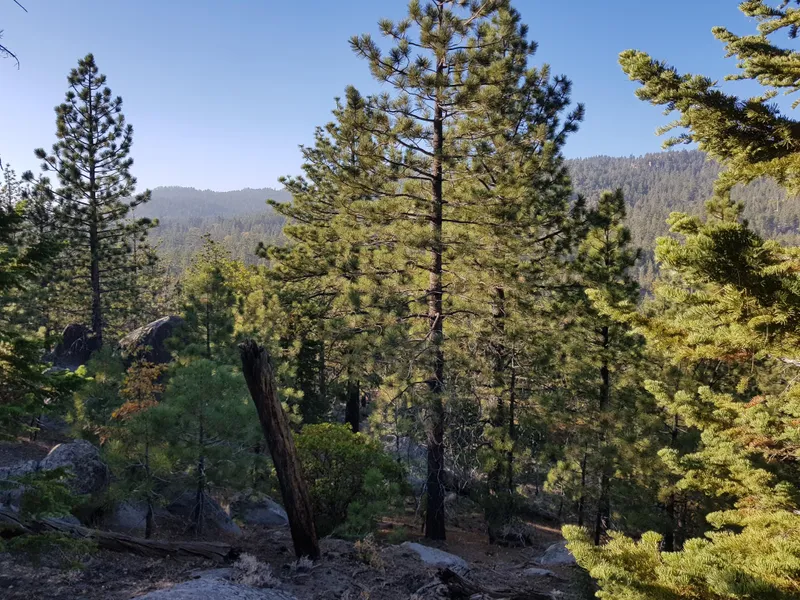
This is a really nice remote piece of land with road access. There is area flat enough to setup whatever you need and then some elevation at the middle of the land offering some really great views of the California hills.
On the northern end, access road driveway exists so that you can pull off the Forest Rd and onto the land.
This land is covered in tall pines with easy ability to traverse the land on foot. Underbrush other than Pine Needles is limited. Well placed boulders give the land some very nice character and no doubt some functional use as well.
Some areas of the land offer some views of the distant tree covered mountains.
Access from the south coming up Franceschi Rd from Caliente is a longer and steeper ride than from the north. This will be slower going.
From the north toward Claraville access from Piute Mt Road (Rt. 501) and then down Jawbone Canyon Rd (Rt. 589) from the East of property. Jawbone Canyon passes Forest Rte 29S02 where you would head west onto 29S02 to the property.
Kern Valley Hospital is 43 Miles within 10 minutes. Numerous mountain peaks are all around you.
Bright Star Wilderness is 22 miles to the north. Beautiful views along with camping, hiking, horseback riding, hunting, wildlife viewing and photo opportunities.
All pictures are taken from the actual property or leading up to it.
County: Kern
APN: 153-280-45-00-8 & 153-280-46-00-1 & 153-280-43-00-2 & 153-280-44-00-5
Legal Description: Parcel Map 5596 , Lot 1 & 2 & 3 & 4
Size: 10 acres
Terrain: Sloped, some boulders, mountain views
Elevation: 3,000 ft
Access: Forest Rte 29S02
Water: Dig a well. Surrounding properties have wells.
Electricity: Solar
Septic: Needed if you build
Zoning: E(2 1/2) RS MH ESTATE 2.5 ACRES, RESIDENTIAL SUBURBAN COMBINING, MOBILEHOME COMBINING
Approximate GPS:
NE
35.40736 N,118.32829 W
NW
35.40737 N,118.32967 W
SE
352421.00N, 1181941.74W
SW
352421.11N, 1181946.74W
From elevation to risk assessment
Search for detailed parcel information including; Elevation & Vegetation Maps, Ownership Information, Detailed Parcel Information, Crop History Map, Soil Survey Productivity Data, and more.
Research Parcel InformationEnvironmental Factors
Resources
Land for Sale by Patrick Young
Kern County Properties By Type
- Farms for Sale in Kern County, California
- Undeveloped Land for Sale in Kern County, California
- Ranches for Sale in Kern County, California
- Residential Property for Sale in Kern County, California
- Riverfront Property for Sale in Kern County, California
- Recreational Property for Sale in Kern County, California
- Hunting Land for Sale in Kern County, California
- Commercial Property for Sale in Kern County, California
- Horse Property for Sale in Kern County, California
- Lakefront Property for Sale in Kern County, California
- Beachfront Property for Sale in Kern County, California
- Timberland for Sale in Kern County, California
Properties for Sale Nearby Counties
- Inyo County, California Land for Sale
- Kings County, California Land for Sale
- Los Angeles County, California Land for Sale
- San Bernardino County, California Land for Sale
- San Luis Obispo County, California Land for Sale
- Santa Barbara County, California Land for Sale
- Tulare County, California Land for Sale
- Ventura County, California Land for Sale
Kern County Properties By City
- Arvin, California Land for Sale
- Bakersfield, California Land for Sale
- Bodfish, California Land for Sale
- Boron, California Land for Sale
- Buttonwillow, California Land for Sale
- Caliente, California Land for Sale
- California City, California Land for Sale
- Cantil, California Land for Sale
- Delano, California Land for Sale
- Edison, California Land for Sale
- Edwards, California Land for Sale
- Fellows, California Land for Sale
- More
- Frazier Park, California Land for Sale
- Glennville, California Land for Sale
- Inyokern, California Land for Sale
- Johannesburg, California Land for Sale
- Keene, California Land for Sale
- Kernville, California Land for Sale
- Lake Isabella, California Land for Sale
- Lamont, California Land for Sale
- Lebec, California Land for Sale
- Lost Hills, California Land for Sale
- Maricopa, California Land for Sale
- Mojave, California Land for Sale
- Onyx, California Land for Sale
- Randsburg, California Land for Sale
- Red Mountain, California Land for Sale
- Ridgecrest, California Land for Sale
- Rosamond, California Land for Sale
- Shafter, California Land for Sale
- Taft, California Land for Sale
- Tehachapi, California Land for Sale
- Tupman, California Land for Sale
- Wasco, California Land for Sale
- Weldon, California Land for Sale
- Wofford Heights, California Land for Sale
- Woody, California Land for Sale
- Aerial Acres, California Land for Sale
- Bear Valley Springs, California Land for Sale
- China Lake, California Land for Sale
- Desert Lake, California Land for Sale
- Di Giorgio, California Land for Sale
- Golden Hills, California Land for Sale
- Gorman, California Land for Sale
- Havilah, California Land for Sale
- Loraine, California Land for Sale
- Mettler, California Land for Sale
- Monolith, California Land for Sale
- Mountain Mesa, California Land for Sale
- North Edwards, California Land for Sale
- Pearsonville, California Land for Sale
- Pine Mountain Club, California Land for Sale
- Pumpkin Center, California Land for Sale
- Sand Canyon, California Land for Sale
- Stallion Springs, California Land for Sale
- Willow Springs, California Land for Sale
- Actis, California Land for Sale
- Algoso, California Land for Sale
- Annette, California Land for Sale
- Ansel, California Land for Sale
- Armistead, California Land for Sale
- Bannister, California Land for Sale
- Bealville, California Land for Sale
- Bena, California Land for Sale
- Bissell, California Land for Sale
- Blackwells Corner, California Land for Sale
- Bowerbank, California Land for Sale
- Bradys, California Land for Sale
- Brown, California Land for Sale
- Burton Mill, California Land for Sale
- Cable, California Land for Sale
- Calders Corner, California Land for Sale
- Camp Owens, California Land for Sale
- Cawelo, California Land for Sale
- Ceneda, California Land for Sale
- Chaffee, California Land for Sale
- Cherokee Strip, California Land for Sale
- China Lake Acres, California Land for Sale
- Cinco, California Land for Sale
- Claraville, California Land for Sale
- Conner, California Land for Sale
- Crome, California Land for Sale
- Derby Acres, California Land for Sale
- Dow, California Land for Sale
- Dustin Acres, California Land for Sale
- East Bakersfield, California Land for Sale
- Edmundson Acres, California Land for Sale
- El Rita, California Land for Sale
- Elmo, California Land for Sale
- Famoso, California Land for Sale
- Fig Orchard, California Land for Sale
- Fleta, California Land for Sale
- Ford City, California Land for Sale
- Fruitvale, California Land for Sale
- Fuller Acres, California Land for Sale
- Garlock, California Land for Sale
- Gloster, California Land for Sale
- Goler Heights, California Land for Sale
- Gosford, California Land for Sale
- Grapevine, California Land for Sale
- Greenacres, California Land for Sale
- Gulf, California Land for Sale
- Gypsite, California Land for Sale
- Halfway House, California Land for Sale
- Harpertown, California Land for Sale
- Harts Place, California Land for Sale
- Hazelton, California Land for Sale
- Hights Corner, California Land for Sale
- Hollis, California Land for Sale
- Ilmon, California Land for Sale
- Jasmin, California Land for Sale
- Jastro, California Land for Sale
- Kayandee, California Land for Sale
- Kecks Corner, California Land for Sale
- Kern, California Land for Sale
- Kern City, California Land for Sale
- Kern Lake, California Land for Sale
- Kernell, California Land for Sale
- Keyesville, California Land for Sale
- Kilowatt, California Land for Sale
- Lackey Place, California Land for Sale
- Lake of the Woods, California Land for Sale
- Landco, California Land for Sale
- Lerdo, California Land for Sale
- Lokern, California Land for Sale
- Lonsmith, California Land for Sale
- Magunden, California Land for Sale
- Maltha, California Land for Sale
- Manolith, California Land for Sale
- Marcel, California Land for Sale
- McFarland, California Land for Sale
- McKittrick, California Land for Sale
- Mexican Colony, California Land for Sale
- Midoil, California Land for Sale
- Millersville, California Land for Sale
- Millux, California Land for Sale
- Minter Village, California Land for Sale
- Miracle Hot Springs, California Land for Sale
- Missouri Triangle, California Land for Sale
- Mitchells Corner, California Land for Sale
- Moreland Mill, California Land for Sale
- Myricks Corner, California Land for Sale
- Neufeld, California Land for Sale
- North Belridge, California Land for Sale
- North Shafter, California Land for Sale
- Oil City, California Land for Sale
- Oil Junction, California Land for Sale
- Oildale, California Land for Sale
- Old Fort Tejon, California Land for Sale
- Old Garlock, California Land for Sale
- Old River, California Land for Sale
- Palmo, California Land for Sale
- Panama, California Land for Sale
- Patch, California Land for Sale
- Pentland, California Land for Sale
- Pettit Place, California Land for Sale
- Pond, California Land for Sale
- Prospero, California Land for Sale
- Quailwood, California Land for Sale
- Quality, California Land for Sale
- Rancho Seco, California Land for Sale
- Rand, California Land for Sale
- Reward, California Land for Sale
- Ribier, California Land for Sale
- Ricardo, California Land for Sale
- Rich, California Land for Sale
- Rio Bravo, California Land for Sale
- Riverkern, California Land for Sale
- Rosedale, California Land for Sale
- Rowen, California Land for Sale
- Saco, California Land for Sale
- Sageland, California Land for Sale
- Saltdale, California Land for Sale
- San Emidio, California Land for Sale
- Sanborn, California Land for Sale
- Searles, California Land for Sale
- Seguro, California Land for Sale
- Semitropic, California Land for Sale
- Shirley Meadows, California Land for Sale
- Silt, California Land for Sale
- Slater, California Land for Sale
- Smith Corner, California Land for Sale
- South Lake, California Land for Sale
- South Taft, California Land for Sale
- Spellacy, California Land for Sale
- Spicer City, California Land for Sale
- Squirrel Mountain Valley, California Land for Sale
- Stevens, California Land for Sale
- Summit, California Land for Sale
- Taft Heights, California Land for Sale
- Thomas Lane, California Land for Sale
- Una, California Land for Sale
- Valley Acres, California Land for Sale
- Venola, California Land for Sale
- Vinland, California Land for Sale
- Wallace Center, California Land for Sale
- Walong, California Land for Sale
- Weedpatch, California Land for Sale
- Wheeler Ridge, California Land for Sale
- Wherry Housing, California Land for Sale
- Wible Orchard, California Land for Sale
- Woodford, California Land for Sale
- Zentner, California Land for Sale