Canal Lot on Newman Waterway
Description
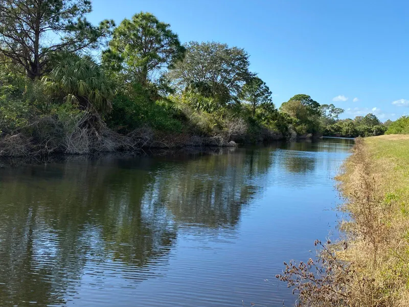
Fish from your backyard or launch your kayak for a paddle down the Newman Waterway to the Cocoplum Waterway and beyond! This .28-acre property is a hidden gem! The setting is a peaceful wonderland with nothing but the sounds of birds singing and fish jumping. The Newman Waterway and its shoreline is a massive 150 feet wide and connects to the nearby Cocoplum Waterway. These are freshwater canals and do not lead to the Gulf, so the atmosphere will always be peaceful and private.
This is in a section of North Port that has not yet been developed but is poised to do so. Around the bend are houses that have been built and power brought to them. Power is just a few lots away.
Minutes to shopping, dining, parks, trail sites, golf courses, Gulf of Mexico beaches, the new Braves stadium, and all that North Port and Port Charlotte have to offer. 17 minutes to the nearest beach and 20-30 minutes away from many others.
Build now, purchase and hold for the future, or buy as an investment. This is an opportunity to get in before the prices go up in this hot market!
Cash Price: $24,995
Address/Location: Lot 8 Harcourt Cir
City/Town: North Port
County: Sarasota
State: Florida
Zip Code: 34288
Parcel Number: 1149-21-3608
Parcel Size: .28-acre
Road Access: Paved Road
Zoning: RSF2 (Single Family Residential)
HOA: None
Flood Zone? No
Scrub Jay Zone? No
Modular or Manufactured homes are allowed
Minimum square footage required: 900 square feet
Power: Power is at the street on Harcourt Cir.
Water: Would be by well
Sewer: Would be by septic
Camping is allowed Camping Rules
Elevation: 23 feet/7.0 meters
Annual Property Taxes: $362
GPS Coordinates:27.0439818, -82.0771774
4 Corners:
27.0441508, -82.0771439
27.0438785, -82.0769293
27.0437966, -82.0770212
27.0439645, -82.0774611
Message Me with any questions.
From elevation to risk assessment
Search for detailed parcel information including; Elevation & Vegetation Maps, Ownership Information, Detailed Parcel Information, Crop History Map, Soil Survey Productivity Data, and more.
Research Parcel InformationDirections
https://goo.gl/maps/ZwToozsb4jDYUjdZA
Environmental Factors
Sarasota County Properties By Type
- Undeveloped Land for Sale in Sarasota County, Florida
- Lakefront Property for Sale in Sarasota County, Florida
- Horse Property for Sale in Sarasota County, Florida
- Farms for Sale in Sarasota County, Florida
- Residential Property for Sale in Sarasota County, Florida
- Beachfront Property for Sale in Sarasota County, Florida
- Riverfront Property for Sale in Sarasota County, Florida
- Ranches for Sale in Sarasota County, Florida
- Commercial Property for Sale in Sarasota County, Florida
- Hunting Land for Sale in Sarasota County, Florida
- Recreational Property for Sale in Sarasota County, Florida
- Timberland for Sale in Sarasota County, Florida
Properties for Sale Nearby Counties
Sarasota County Properties By City
- Englewood, Florida Land for Sale
- Laurel, Florida Land for Sale
- Longboat Key, Florida Land for Sale
- Nokomis, Florida Land for Sale
- North Port, Florida Land for Sale
- Osprey, Florida Land for Sale
- Sarasota, Florida Land for Sale
- Venice, Florida Land for Sale
- Crescent Beach, Florida Land for Sale
- Grove City, Florida Land for Sale
- Pinecraft, Florida Land for Sale
- Siesta Key, Florida Land for Sale
- More
- Bailey Hall, Florida Land for Sale
- Bee Ridge, Florida Land for Sale
- Belspur, Florida Land for Sale
- Beverley Terrace, Florida Land for Sale
- Desoto Lakes, Florida Land for Sale
- Fordville, Florida Land for Sale
- Fruitville, Florida Land for Sale
- Hidden River, Florida Land for Sale
- Honore, Florida Land for Sale
- Kensington Park, Florida Land for Sale
- Lake Sarasota, Florida Land for Sale
- Laurel Villa, Florida Land for Sale
- Manasota Beach, Florida Land for Sale
- Miakka, Florida Land for Sale
- Nokomis Beach, Florida Land for Sale
- North Sarasota, Florida Land for Sale
- Old Myakka, Florida Land for Sale
- Point O'Rocks, Florida Land for Sale
- Ridge Wood Heights, Florida Land for Sale
- Sarasota Heights, Florida Land for Sale
- Sarasota Springs, Florida Land for Sale
- Shiney Town, Florida Land for Sale
- South Gate Ridge, Florida Land for Sale
- South Sarasota, Florida Land for Sale
- South Trail, Florida Land for Sale
- South Venice, Florida Land for Sale
- Southgate, Florida Land for Sale
- Southwest Venice, Florida Land for Sale
- Sunnyland, Florida Land for Sale
- Tarpon Point, Florida Land for Sale
- Tatum, Florida Land for Sale
- Tatum Ridge, Florida Land for Sale
- The Meadows, Florida Land for Sale
- Vamo, Florida Land for Sale
- Venice Beach, Florida Land for Sale
- Venice East, Florida Land for Sale
- Venice Gardens, Florida Land for Sale
- Venice Groves, Florida Land for Sale
- Warm Mineral Springs, Florida Land for Sale
- White Beach, Florida Land for Sale
- Woodmere, Florida Land for Sale