Long View on Sunset Ridge
Description
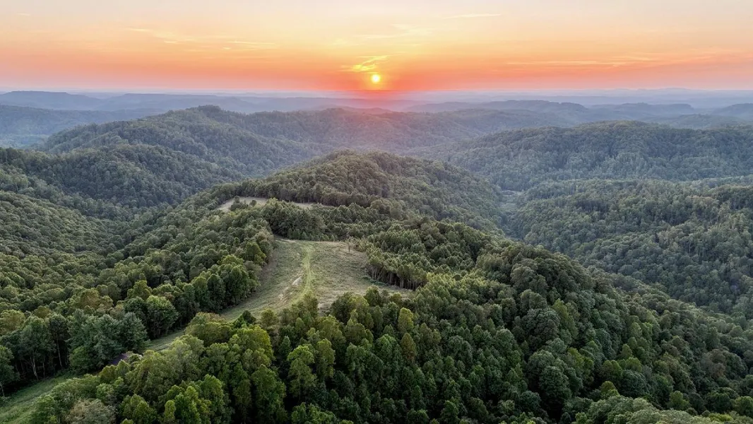
LONG VIEW ON SUNSET RIDGE This 91-acre (+/-) woodland property on the summit of Great Flat Top Mountain includes more than eight acres of pasture with exceptional sunset views. Private, though not remote, its a 30-minute drive to the nearest small cities, Mullens and Princeton. An ideal location for an outdoor getaway, nearby recreational attractions include parks, hunting lands, and ATV trails, and one of the most popular ski resorts in the southeast, Winterplace, is a 45-minute drive away. Two state parks are within 35 minutes, and national parks and forests are within 60.
HIGHLIGHTS
91 acres (+/-), approximately 82 in forest
Approximately eight acres of pasture
Exceptional views northward and westward
Electric service, cellular service, Starlink not confirmed
Suited to development as home sites and lodging rentals
Convenient to ATV trails, hunting lands, historic sites
Adjoining hunting land for grouse, deer, and turkey
Cove hardwood forests with mature stands, not surveyed
Interior trails for hiking, biking, equestrian, and ATV riding
Source of Milam Creek catch-and-release trout hatchery
Low light pollution, excellent stargazing
Bold spring water source and spring-fed pond
45 minutes from Winterplace ski area
ABOUT THE VIEWS
Hilltop fields at the heart of the property afford remarkable views to the north and west. Mountain peaks as far as 27 miles away suggest the view includes more than 70 square miles. The farthest confirmed peaks include Ivy Knob, at nearly 23 miles away, and Burning Rock, at 27 miles. Ideally suited for star-gazing and night observation, remarkably few light sources interrupt the view.
LOCATION
Google Coordinates: 37.499912(N), -81.261543(W)
Address: 1737 Milam Fork Black Road, Herndon, WV 24726
Elevation Range: 2,689 to 3,195 feet above sea level
FOREST/TIMBER RESOURCES
An assessment of timber resources has not been performed. Large stands of mature tulip poplar have been observed throughout the property. The forest is a tremendous producer of Oxygen and Carbon Sequester. Carbon sequestration is the act of processing carbon dioxide through sinks and stores and releasing it into the atmosphere as oxygen. With 91 acres, the vigorously growing forest sequesters approximately a quarter million tons of carbon dioxide annually. On average, one tree produces nearly 260 pounds of oxygen each year.
WILDLIFE
The property and region are home to abundant wildlife. A drive of at least 30 miles from the nearest population centers, it is surrounded on all sides by vast forests, notably Camp Creek State Forest, which protects more than 5,269 acres for public hunting and recreation. Wildlife include bear, deer, grouse, fox, mink, squirrel, raccoon, turkey, beaver, bobcat, and muskrat. Songbirds and waterfowl are common, as are larger birds of prey, including owls, hawks, and the occasional bald eagle. The cool streams that descend off the mountain support trout. Hunting is a favorite pastime in the region, and hunting is permitted in the thousands of acres surrounding the property.
WATER
On the headwaters of Milam Fork of Barkers Creek, the property includes a dashed blueline stream, which carries water much of the year. It is fed by a bold spring, which provides water year-round and feeds a quarter-acre woodland pond. Other small springs are located elsewhere on the property.
STAR GAZING
Ideally suited for star-gazing and planet observation, the ridge-top fields on the property provide exceptional views north and west across a region of more than 70 square miles. The viewshed includes remarkably few light sources.
MINERAL RESOURCES
West Virginia is one of the states in the US that has two ownership titles, those being SURFACE RIGHTS and MINERAL RIGHTS. A title search for mineral rights ownership has not been conducted. All rights the owner has will convey with the property. A mineral title search could be conducted by a title attorney at the same time when the surface title search is being conducted.
BOUNDARIES AND SURVEY
The property is being sold by the boundary and not by the acre.
UTILITIES
Water: Springs
Sewer: None
Electricity: American Electric Power
Telephone: Cellular Carriers
Internet: Starlink, Satellite
ACCESS/FRONTAGE
The propertys access road connects to Egeria Road (Rural Route 1).
ZONING
Wyoming County is subject to some zoning and subdivision regulations. All prospective buyers should consult the County Commission and also the Health Department for details regarding zoning, building codes and installation of septic systems.
PROPERTY TYPE/USE SUMMARY
There is a ridge-top field with vintage barn that contains about 1.7 acres. The balance of the property is in various-age forestland.
(This summary is an estimation of current property use as determined from aerial photography. It is made subject to the estimation of property boundaries and any errors in the interpretation of land use type from the aerial photography utilized.)
DEED and TAX INFORMATION
Deed Information: DB 452 Pg. 502
Wyoming County, West Virginia
Acreage: 90.9 acres +/-
Real Estate Tax ID/Acreage/Taxes:
Wyoming County (55), West Virginia
Barkers Ridge District (2)
Tax Map 129 Parcels 2,3,4; Class 3;
2023 Real Estate Taxes: $218.50
From elevation to risk assessment
Search for detailed parcel information including; Elevation & Vegetation Maps, Ownership Information, Detailed Parcel Information, Crop History Map, Soil Survey Productivity Data, and more.
Research Parcel InformationDirections
DIRECTIONS
From Mullens, West Virginia
follow WV-16 west 2.3 miles to a left turn onto WV-10. Follow the latter south 12.4 miles to a left turn onto Flat Top-Egeria Road, a one-lane rural route. Follow east 2.8 miles to a left onto an unnamed gravel route. Follow the latter approximately 2,500 feet to a left turn into the driveway. (Approximate drive time: 30 minutes)
From Princeton, West Virginia
follow WV-10 north 18.3 miles to a right turn onto Flat Top-Egeria Road, a one-lane rural route. Follow east 2.8 miles to a left onto an unnamed gravel route. Follow the latter approximately 2,500 feet to a left turn into the driveway. (Approximate drive time: 35 minutes)
From Ghent (Winterplace), West Virginia
follow Odd Road west 5.4 miles to a right turn onto Flat Top-Egeria Road, a one-lane rural route. Follow west 10.6 miles to a right onto an unnamed gravel route. Follow the latter approximately 2,500 feet to a left turn into the driveway. (Approximate drive time: 40 minutes)
Environmental Factors
Resources
- Long View on Sunset Ridge Google Earth map (Foxfire).pdf
- Long View on Sunset Ridge area map (Foxfire).pdf
- Long View on Sunset Ridge general location map 1 (Foxfire).pdf
- Long View on Sunset Ridge general location map 2 (Foxfire).pdf
- Long View on Sunset Ridge highway map 1 (Foxfire).pdf
- Long View on Sunset Ridge highway map 2 (Foxfire).pdf
- Long View on Sunset Ridge topographic map (Foxfire).pdf
- LANE - DEED BOOK (452-502)1-2.pdf
- LANE - 911 Address for one tract.pdf
- signed NOA - Lane - Sibray.pdf
- signed NOA - Lane -RSB.pdf
- Narrative for Long View on Sunset Ridge.docx
Wyoming County Properties By Type
- Farms for Sale in Wyoming County, West Virginia
- Commercial Property for Sale in Wyoming County, West Virginia
- Residential Property for Sale in Wyoming County, West Virginia
- Recreational Property for Sale in Wyoming County, West Virginia
- Riverfront Property for Sale in Wyoming County, West Virginia
- Undeveloped Land for Sale in Wyoming County, West Virginia
- Hunting Land for Sale in Wyoming County, West Virginia
- Lakefront Property for Sale in Wyoming County, West Virginia
- Timberland for Sale in Wyoming County, West Virginia
- Ranches for Sale in Wyoming County, West Virginia
- Horse Property for Sale in Wyoming County, West Virginia
- Beachfront Property for Sale in Wyoming County, West Virginia
Properties for Sale Nearby Counties
Wyoming County Properties By City
- Allen Junction, West Virginia Land for Sale
- Amigo, West Virginia Land for Sale
- Brenton, West Virginia Land for Sale
- Bud, West Virginia Land for Sale
- Clear Fork, West Virginia Land for Sale
- Coal Mountain, West Virginia Land for Sale
- Corinne, West Virginia Land for Sale
- Covel, West Virginia Land for Sale
- Cyclone, West Virginia Land for Sale
- Fanrock, West Virginia Land for Sale
- Glen Fork, West Virginia Land for Sale
- Glen Rogers, West Virginia Land for Sale
- More
- Hanover, West Virginia Land for Sale
- Herndon, West Virginia Land for Sale
- Ikes Fork, West Virginia Land for Sale
- Itmann, West Virginia Land for Sale
- Jesse, West Virginia Land for Sale
- Kopperston, West Virginia Land for Sale
- Lynco, West Virginia Land for Sale
- Maben, West Virginia Land for Sale
- Marianna, West Virginia Land for Sale
- Matheny, West Virginia Land for Sale
- Mullens, West Virginia Land for Sale
- New Richmond, West Virginia Land for Sale
- North Spring, West Virginia Land for Sale
- Oceana, West Virginia Land for Sale
- Pineville, West Virginia Land for Sale
- Ravencliff, West Virginia Land for Sale
- Rock View, West Virginia Land for Sale
- Sabine, West Virginia Land for Sale
- Saulsville, West Virginia Land for Sale
- Simon, West Virginia Land for Sale
- Stephenson, West Virginia Land for Sale
- Wyco, West Virginia Land for Sale
- Wyoming, West Virginia Land for Sale
- Crany, West Virginia Land for Sale
- Hatcher, West Virginia Land for Sale
- Rollins Branch, West Virginia Land for Sale
- Alpoca, West Virginia Land for Sale
- Baileysville, West Virginia Land for Sale
- Basin, West Virginia Land for Sale
- Big Branch, West Virginia Land for Sale
- Black, West Virginia Land for Sale
- Blackeagle, West Virginia Land for Sale
- Cub City, West Virginia Land for Sale
- Edith, West Virginia Land for Sale
- Elmore, West Virginia Land for Sale
- Fanny, West Virginia Land for Sale
- Garwood, West Virginia Land for Sale
- Glover, West Virginia Land for Sale
- Guyan, West Virginia Land for Sale
- Herndon Heights, West Virginia Land for Sale
- Iroquois, West Virginia Land for Sale
- Joe Branch, West Virginia Land for Sale
- Keyrock, West Virginia Land for Sale
- Lacoma, West Virginia Land for Sale
- Lillydale, West Virginia Land for Sale
- Lillyhaven, West Virginia Land for Sale
- Lincoln, West Virginia Land for Sale
- McGraws, West Virginia Land for Sale
- Micajah, West Virginia Land for Sale
- Montecarlo, West Virginia Land for Sale
- Mullensville, West Virginia Land for Sale
- Newfound, West Virginia Land for Sale
- Nuriva, West Virginia Land for Sale
- Otsego, West Virginia Land for Sale
- Polk Gap, West Virginia Land for Sale
- Stoneville, West Virginia Land for Sale
- Sun Hill, West Virginia Land for Sale
- Toney Fork, West Virginia Land for Sale
- Tralee, West Virginia Land for Sale
- Turkey, West Virginia Land for Sale
- Uno, West Virginia Land for Sale
- Windom, West Virginia Land for Sale
- Woosley, West Virginia Land for Sale