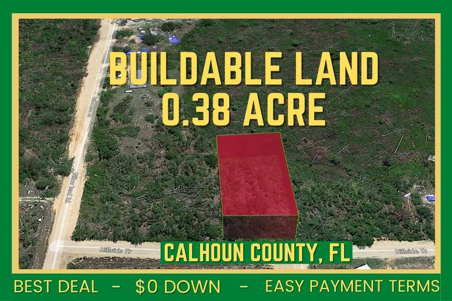
Own 0.38 Acre of Buildable Land! Calhoun County, FL. ZERO DOWN!
Have you Dreamed of getting off-grid? Come take a look and explore the world around you!
It is located in Hillside Tr NW Altha, FL in West Calhoun County, FL 32421. The Power is in the area, camping, Rvs, mobile home, and tiny home are allowed on the property. It has dirt road access to the, and the terrain is flat and wooded. The Land cover is Woody Wetlands: 0.38ac (100%). Tallahassee, Florida, USA 1 hr 21 min (73.9 miles) and Altha, Florida 32421, USA 18 min (14.4 miles)
Enjoy, and relax while the land value appreciates. Get your own quiet place, and enjoy spending quality time with your loved ones. Dont miss out on this wonderful 0.38 Acre land in Calhoun County, FL!
Own and build a nice home with so many activities to do in the fun side of Florida area land.
No one could stop you from stargazing in absolute solitude, riding your ATV, camping, or building your off-grid homesite.
The sunrise will bring you to hope, and the sunset will bring you peace. Take your deep breath and enjoy the benefits of the sunrise and the beauty of a sunset here on 0.38 Acre Land in beautiful Calhoun County, FL.
Secure this land today!!
Nearby Attractions:
Look and Tremble Rapids 16 min (11.3 miles)
Sam Atkins Park 25 min (20.2 miles)
Magnolia Square 26 min (20.9 miles)
Blue Spring Recreation Area 27 min (22.9 miles)
Veterans Memorial Railroad (ORG) 34 min (25.9 miles)
Gulf World 1 hr 6 min (55.1 miles)
Sea Dragon Pirate Cruise 1 hr 7 min (49.2 miles)
Gulf Coast Jet Boats 1 hr 9 min (49.0 miles)
Property Details
Street Address: Yes, via Hillside Tr
City: Altha
State: FL
County: Calhoun
Zip Code: 32421
Size: 0.38
Lot Dimensions: Approx: 100.32 ft x 163.68 ft x 100.32 ft x 168.96 ft
APN: 11-1N-11-0560-0014-1100
Legal Description: BEG NE/C LT 11 BLK 14 LAKE MCK ENZIE HOMES PB 1-52 FOR POB S ALNG E LN SD LT 11 163.64FT TO SW/C LT 2 BLK 14 W 100FT TO W LN LT 11 BLK 14 N ALNG W LN SD LT 11 163.64FT TO NW/C SD LT 11 E ALNG N LN 100FT TO POB OR 316-157
Google Maps: Click Here!
Coordinates: 30.502167, -85.306222
Elevation: 180 ft
Annual Taxes: $83.78 (2020)
Zoning Vacant - Residential
HOA/POA: N/A
Access: Hillside Tr
Sewer: Would need to install septic
Water: Would need to dig well
Utilities: Power in the area - needs to be installed
Camping Allowed: Yes
RV Allowed: Yes
Mobile Home Allowed: Yes
Tiny Home Allowed: Yes
Pricing:
$199 Doc Fee $6000 Cash or $400 per month for 24 months
Message me about all information on this property.
From elevation to risk assessment
Search for detailed parcel information including; Elevation & Vegetation Maps, Ownership Information, Detailed Parcel Information, Crop History Map, Soil Survey Productivity Data, and more.
Research Parcel InformationResources
Land for Sale by Scott Bossman and Mike Zaino
Calhoun County Properties By Type
- Hunting Land for Sale in Calhoun County, Florida
- Farms for Sale in Calhoun County, Florida
- Undeveloped Land for Sale in Calhoun County, Florida
- Lakefront Property for Sale in Calhoun County, Florida
- Riverfront Property for Sale in Calhoun County, Florida
- Ranches for Sale in Calhoun County, Florida
- Residential Property for Sale in Calhoun County, Florida
- Recreational Property for Sale in Calhoun County, Florida
- Timberland for Sale in Calhoun County, Florida
- Horse Property for Sale in Calhoun County, Florida
- Commercial Property for Sale in Calhoun County, Florida
- Beachfront Property for Sale in Calhoun County, Florida
Properties for Sale Nearby Counties
Calhoun County Properties By City
- Altha, Florida Land for Sale
- Blountstown, Florida Land for Sale
- Clarksville, Florida Land for Sale
- Kinard, Florida Land for Sale
- Abe Springs, Florida Land for Sale
- Broad Branch, Florida Land for Sale
- Chason, Florida Land for Sale
- Chipola, Florida Land for Sale
- Cox, Florida Land for Sale
- Fisher Corner, Florida Land for Sale
- Frink, Florida Land for Sale
- Gaskins, Florida Land for Sale
- More
- Henderson Mill, Florida Land for Sale
- Marysville, Florida Land for Sale
- Ocheesee, Florida Land for Sale
- Ocheesee Landing, Florida Land for Sale
- Pine Island, Florida Land for Sale
- Rollins Corner, Florida Land for Sale
- Scotts Ferry, Florida Land for Sale
- Selman, Florida Land for Sale
- Sharpstown, Florida Land for Sale
- Willis, Florida Land for Sale