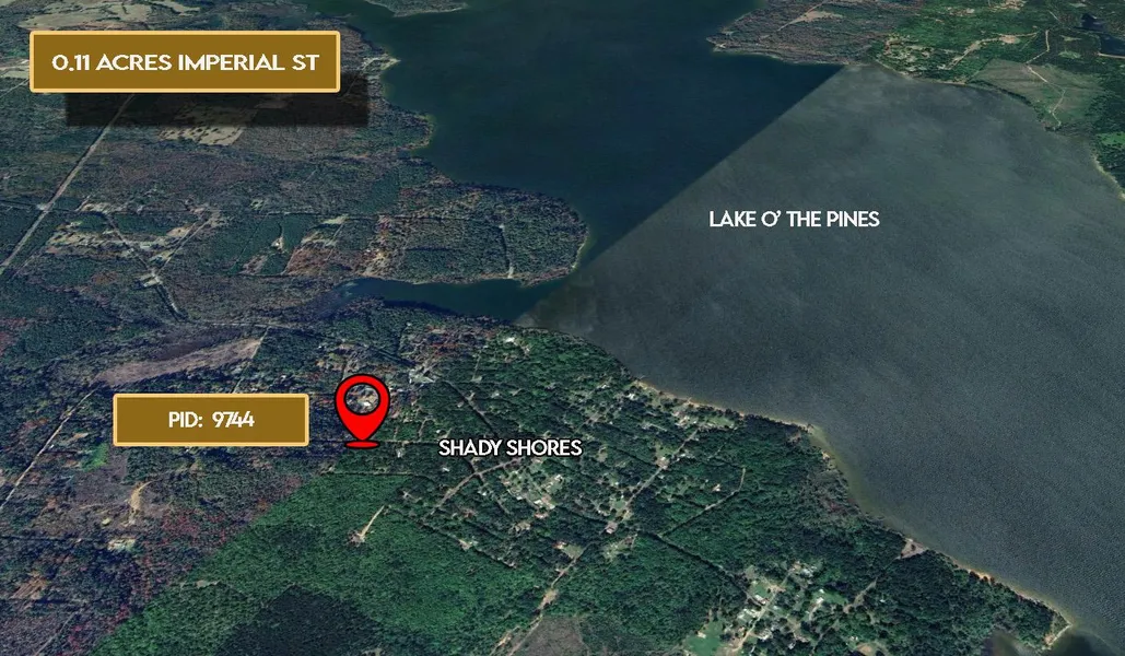
.11 Acres Imperial St, Ore City, TX 75683
Description
Full-time RV living is allowed pull up your RV and stay as long as you like while enjoying the lake. Build a tiny home, modular, mobile home, or even stick-built the choice is yours!
No credit checks owner financing available $150 down and $150 a month.
Looking for land where you can truly live on your terms? This 0.11-acre lot is located just minutes from Lake O the Pines in the Shady Shores Subdivision in Marion County, Texas.
There's no POA, and property taxes are only $12 per year. There are too many good things to list.
This is the perfect chance to own a private getaway, permanent homesite, or long-term investment in one of East Texas most beautiful lake regions. $150 down and $150 a month call us today!
Cash Price: $4,500
Term Option 1: $150 down, $150 for 33 months, for a total price of $5,100
Term Option 2: $200 down, $200 for 24 months, for a total price of $5,000
Term Option 3: $250 down, $250 for 18 months, for a total price of $4,750
Parcel ID: 9744
Address: Imperial St, Ore City, TX 75683
GPS Coordinates (center) at the road: 32.7947, -94.6555
Northwest Corner: 32.7946, -94.6556
Northeast Corner: 32.7947, -94.6555
Southwest Corner: 32.7944, -94.6554
Southeast Corner: 32.7945, -94.6553
Legal Description: SHADY SHORES HILL DALE SECLOT 125 of Marion County, Texas
Elevation: 352'
Approx Dimensions: 50' x 100'
Terrain: Slope
Access: Dirt Road
Power: Power in the area
Water: Water in the area
Water Fees Per Year: $0
Sewer: Septic needed
Zoning: Residential
RV Living: Allowed
Modular Homes Allowed: Allowed
Tiny Homes Friendly: Allowed
RV on the Property While you build: Allowed
Mobile Home Living: Allowed
Manufactured Homes: Allowed
POA: $0
POA Fees Per Year: $0
Taxes Per Year: $12
Road Fee: $0
County Contact Information: Marion County Clerk (903) 665-3971
Conveyance: Warranty Deed
From elevation to risk assessment
Search for detailed parcel information including; Elevation & Vegetation Maps, Ownership Information, Detailed Parcel Information, Crop History Map, Soil Survey Productivity Data, and more.
Research Parcel InformationDirections
Address: Imperial St, Ore City, TX 75683
GPS Coordinates (center) at the road: 32.7947, -94.6555
Northwest Corner: 32.7946, -94.6556
Northeast Corner: 32.7947, -94.6555
Southwest Corner: 32.7944, -94.6554
Southeast Corner: 32.7945, -94.6553
Environmental Factors
Resources
Marion County Properties By Type
- Ranches for Sale in Marion County, Texas
- Farms for Sale in Marion County, Texas
- Undeveloped Land for Sale in Marion County, Texas
- Lakefront Property for Sale in Marion County, Texas
- Hunting Land for Sale in Marion County, Texas
- Residential Property for Sale in Marion County, Texas
- Timberland for Sale in Marion County, Texas
- Riverfront Property for Sale in Marion County, Texas
- Horse Property for Sale in Marion County, Texas
- Recreational Property for Sale in Marion County, Texas
- Commercial Property for Sale in Marion County, Texas
- Beachfront Property for Sale in Marion County, Texas
Properties for Sale Nearby Counties
Marion County Properties By City
- Avinger, Texas Land for Sale
- Jefferson, Texas Land for Sale
- Lodi, Texas Land for Sale
- Gray, Texas Land for Sale
- Smithland, Texas Land for Sale
- Warlock, Texas Land for Sale
- Burford, Texas Land for Sale
- Gethsemane, Texas Land for Sale
- Kellyville, Texas Land for Sale
- Lassater, Texas Land for Sale
- Mims Chapel, Texas Land for Sale
- Orrs, Texas Land for Sale
- More