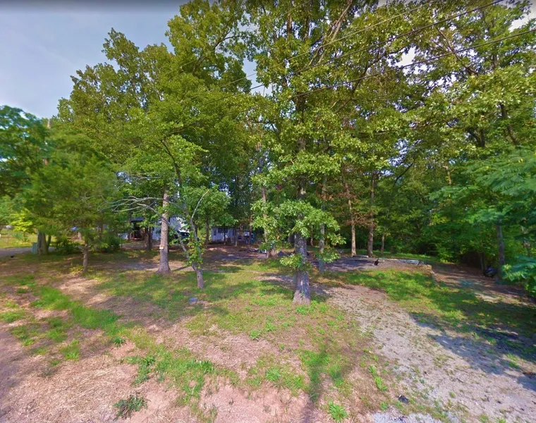
0.28 Acre in Irondale, Missouri
This 0.28 acre lot is located in Irondale, Missouri and the address is Iroquois Drive, Irondale, MO 63648.
Irondale is a town in Missouri with a population of 575. Irondale is in Washington County.
Living in Irondale offers residents a rural feel and most residents own their homes. Many families live in Irondale and residents tend to be conservative. The public schools in Irondale are above average.
Features: No POA, close to Lakes
Only $300 Down and $250/month for 56 months = $14300 or Discounted Cash Price: $11500
PROPERTY DETAILS
APN: 21-6.0-014-001-006-009.00000
Address: Iroquois Drive, Irondale, MO 63648
County: Washington
State: Missouri
Size: 0.28 Acre
Dimensions: 84' x 149'
Legal: LOT 216 PLAT 5 CAMP IRONDALE ESTATES
Terrain: Flat
Access: Paved Road
Power: Power at the lot
Water: Water in the area
Sewer: Would be by Septic
Taxes per Year: $29
HOA Fees per Year: No HOA/POA
GPS Coordinates (center) at the road: 37.836950, -90.662780
--- Northwest Corner: 37.837078, -90.663034
--- Northeast Corner: 37.837075, -90.662523
--- Southwest Corner: 37.836847, -90.663038
--- Southeast Corner: 37.836846, -90.662527
Elevation: 959
BUILDING INFORMATION
Zoning: MO-Washington-Irondale-R2-Residential-Mobile-Home
Time Limit to Build: No time limit to build
Site Built Homes Allowed: Al;lowed 960 min Sqft
Modular Homes Allowed: Allowed 750 min sq ft
Manufactured Homes Allowed: Allowed 750 min sq ft
Mobile Homes Allowed: Allowed 750 min sq ft
Tiny Homes Friendly: Not Allowed
ALLOWABLE USES
Full-Time RV Living Allowed: Not Allowed
RV on the Property While I build: allowed 3months
Camping in a RV Allowed: Not Allowed
From elevation to risk assessment
Search for detailed parcel information including; Elevation & Vegetation Maps, Ownership Information, Detailed Parcel Information, Crop History Map, Soil Survey Productivity Data, and more.
Research Parcel InformationDirections
From Breton Township
Missouri, USA
1.Head southeast on MO-8 E toward Weir Dr
2.Turn right onto Benny Meyer Rd
3.Turn right onto State Hwy M
4.Turn left onto Cheyenne
5.Turn left onto W Apache Dr
6.Turn left onto Sioux Dr
7.Turn left onto Iroquois Dr
8.Lot is on the left
Resources
Land for Sale by Benjamin Davis
Washington County Properties By Type
- Farms for Sale in Washington County, Missouri
- Hunting Land for Sale in Washington County, Missouri
- Residential Property for Sale in Washington County, Missouri
- Undeveloped Land for Sale in Washington County, Missouri
- Lakefront Property for Sale in Washington County, Missouri
- Riverfront Property for Sale in Washington County, Missouri
- Ranches for Sale in Washington County, Missouri
- Commercial Property for Sale in Washington County, Missouri
- Timberland for Sale in Washington County, Missouri
- Recreational Property for Sale in Washington County, Missouri
- Horse Property for Sale in Washington County, Missouri
- Beachfront Property for Sale in Washington County, Missouri
Properties for Sale Nearby Counties
Washington County Properties By City
- Belgrade, Missouri Land for Sale
- Blackwell, Missouri Land for Sale
- Cadet, Missouri Land for Sale
- Caledonia, Missouri Land for Sale
- Fletcher, Missouri Land for Sale
- Irondale, Missouri Land for Sale
- Mineral Point, Missouri Land for Sale
- Potosi, Missouri Land for Sale
- Richwoods, Missouri Land for Sale
- Tiff, Missouri Land for Sale
- Old Mines, Missouri Land for Sale
- Springtown, Missouri Land for Sale
- More
- Anthonies Mill, Missouri Land for Sale
- Aptus, Missouri Land for Sale
- Baryties, Missouri Land for Sale
- Bates Creek Camp, Missouri Land for Sale
- Bliss, Missouri Land for Sale
- Brazil, Missouri Land for Sale
- Camp Lakewood, Missouri Land for Sale
- Cannon Mines, Missouri Land for Sale
- Cruise Mill, Missouri Land for Sale
- Delbridge, Missouri Land for Sale
- Ebo, Missouri Land for Sale
- Fertile, Missouri Land for Sale
- Floyd, Missouri Land for Sale
- Fountain Farm, Missouri Land for Sale
- French Town, Missouri Land for Sale
- Frogtown, Missouri Land for Sale
- Happy Hollow, Missouri Land for Sale
- Holiday Shores, Missouri Land for Sale
- Horton Town, Missouri Land for Sale
- Hulsey, Missouri Land for Sale
- Ishmael, Missouri Land for Sale
- Latty, Missouri Land for Sale
- Levy, Missouri Land for Sale
- Maddens Richwoods, Missouri Land for Sale
- Mud Town, Missouri Land for Sale
- Northcut, Missouri Land for Sale
- Palmer, Missouri Land for Sale
- Peoria, Missouri Land for Sale
- Quaker, Missouri Land for Sale
- Rabbitville, Missouri Land for Sale
- Racola, Missouri Land for Sale
- Robidoux, Missouri Land for Sale
- Shibboleth, Missouri Land for Sale
- Shirley, Missouri Land for Sale
- Sunlight, Missouri Land for Sale
- Theabeau Town, Missouri Land for Sale