Agricultural Greatness Kettleman City, Ca. Kings COUNTY
Agricultural Greatness
Kettleman City, Ca.
Kings COUNTY
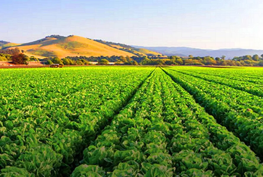
This agricultural Land is in the vicinity of Kettleman City; is a census-designated place in Kings County, Ca. Kettleman City is located 28 miles southwest of Hanford, 54 miles south of Fresno, at an elevation of 253 feet, and sits only about 1/2-mile North of the 36th parallel north latitude. It is part of the HanfordCorcoran Metropolitan Statistical Area. The population was 1,439 at the 2010 census, down from 1,499 at the 2000 census. Kettleman City is near the halfway point between Los Angeles and San Francisco or Sacramento on Interstate 5 at Exit 309, and thus is a major stopping point for food and lodging. Kettleman City is located on the west side of the San Joaquin Valley at the base of the Kettleman Hills, near the historic shoreline of what used to be Tulare Lake. There is considerable service commercial development at the Interstate 5/State Route 41 junction to meet the needs of highway travelers.
Many local residents are employed in agriculture, which experienced significant growth on the west side of the San Joaquin Valley after the completion of the California Aqueduct in the early 1970s.
Attached is the Kings County Assessors Map of the Lot as well as some maps of the area and some pictures.
The property will be conveyed by a California Grant Deed which is the most commonly used deed in California.
Values are on the rise! Dont miss out on this one!
Property Profile:
Property Address: Kettleman City, CA 93239
APN: 038-240-044-000
Use Type: Agricultural
Lot Size: 10.14 Acres
HOA: NO HOA fees.
State/Province: California
Taxes: Only $5 per Year each parcel
County: Kings
Deed: Grant Deed
City/ Location: Kettleman City, CA 93239 See Map.
The photos 2, 4, 6, 8, 10 and 12 show the actual property and the surrounding lots. Photos 1, 3, 5, 7, 9, and 11 shows general area.
We have also included a County Parcel Map and an aerial Map to help you. The assessor's parcel number to the property is Kings County APN # 038-240-044-000
Here is a link (including the GPS coordinates) to view the location of the property on Google Maps:
36.001827,-120.014016
(You may have to copy and paste this to use it.) Once the map pops up, simply use the zoom tool on the left side of that screen to view the map in more detail. You can even view an aerial photo by clicking on the Satellite tab in the upper right portion of that screen.
All information we have on this property is disclosed within the content of the listing page. Any and all other information on this property should be directed toward the city or county of which the property is located in. Your due diligence should be performed prior to bidding, to ensure the property meets your needs and criteria.
From elevation to risk assessment
Search for detailed parcel information including; Elevation & Vegetation Maps, Ownership Information, Detailed Parcel Information, Crop History Map, Soil Survey Productivity Data, and more.
Research Parcel InformationEnvironmental Factors
Land for Sale by Javier Prodiz
Kings County Properties By Type
- Farms for Sale in Kings County, California
- Ranches for Sale in Kings County, California
- Undeveloped Land for Sale in Kings County, California
- Residential Property for Sale in Kings County, California
- Commercial Property for Sale in Kings County, California
- Horse Property for Sale in Kings County, California
- Lakefront Property for Sale in Kings County, California
- Riverfront Property for Sale in Kings County, California
- Recreational Property for Sale in Kings County, California
- Timberland for Sale in Kings County, California
- Beachfront Property for Sale in Kings County, California
- Hunting Land for Sale in Kings County, California
Properties for Sale Nearby Counties
Kings County Properties By City
- Armona, California Land for Sale
- Avenal, California Land for Sale
- Corcoran, California Land for Sale
- Hanford, California Land for Sale
- Kettleman City, California Land for Sale
- Lemoore, California Land for Sale
- Stratford, California Land for Sale
- Cimarron, California Land for Sale
- Acebedo, California Land for Sale
- Fort Roosevelt, California Land for Sale
- Gepford, California Land for Sale
- Grangeville, California Land for Sale
- More
- Guernsey, California Land for Sale
- Halls Corner, California Land for Sale
- Hamblin, California Land for Sale
- Hardwick, California Land for Sale
- Helm Corner, California Land for Sale
- Home Garden, California Land for Sale
- Hydril, California Land for Sale
- Kettleman Station, California Land for Sale
- Murray, California Land for Sale
- Pitco, California Land for Sale
- Reef Station, California Land for Sale
- Remnoy, California Land for Sale
- Rossi, California Land for Sale
- Shell, California Land for Sale
- South Corcoran, California Land for Sale