2.86 Acres, Lame Deer Ridge Rd, Watts OK 74964
***Seller Financing available for this property as little as $450 down and $450 a month***
Located in the peaceful Illinois River Ranch community, this 2.86-acre lot is ideal for a dream home, weekend retreat, or a place to park your RV or mobile home. Enjoy privacy, natural surroundings, and nearby river access just an hour from Siloam Springs, AR and Tahlequah, OK.
With no HOA and no building restrictions, you have the freedom to create the space you want.
Don't miss your chance to own a piece of Oklahoma's best-kept secret.
Cash Price: $21,000
Term Option 1: $450 down, $450 for 58 months, for a total price of $26,550
Term Option 2: $550 down, $550 for 45 months, for a total price of $25,300
Term Option 3: $650 down, $650 for 36 months, for a total price of $24,050
Parcel ID: 0480-00-002-200-0-000-00
Address: Lame Deer Ridge Rd, Watts OK 74964
GPS Coordinates (center) at the road: 36.0889,-94.7918
Northwest Corner: 36.089,-94.7929
Northeast Corner: 36.09,-94.7919
Southwest Corner: 36.0885,-94.7923
Southeast Corner: 36.0894,-94.7914
Legal Description: Block 2, Lot 200 Illinois River Ranch
Elevation: 1080'
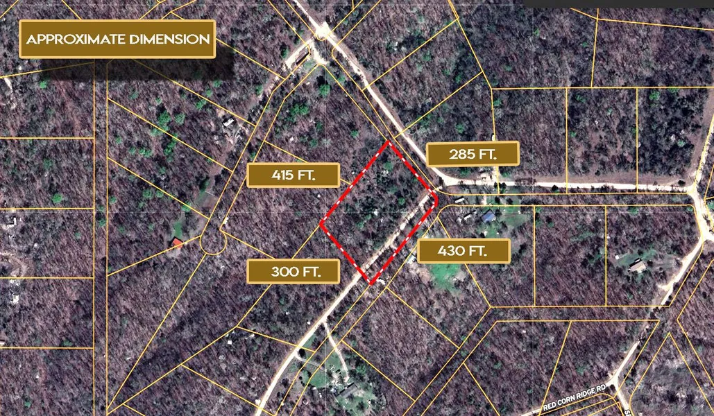
Approx Dimensions: 430' x 285' x 418' x 300'
Terrain: Sloping
Access: Dirt Road
Power: Power is provided by Ozarks Electric Cooperative (800-521-6144)
Water: Water is provided by Adair Co. RWS & SWMD #6 (918-397-6296)
Water Fees Per Year: Unknown (Contact County)
Sewer: Septic Needed
Zoning: Residential
RV Living: Allowed
Modular Homes Allowed: Allowed
Tiny Homes Friendly: Allowed
RV on the Property While you build: Allowed
Mobile Home Living: Allowed
Manufactured Homes: Allowed
POA: $0
POA Fees Per Year: $0
Taxes Per Year: $26
Road Fee: Unknown (Contact County)
County Contact Information: Adair County Clerk (270) 384-2801
Conveyance: Warranty Deed
From elevation to risk assessment
Search for detailed parcel information including; Elevation & Vegetation Maps, Ownership Information, Detailed Parcel Information, Crop History Map, Soil Survey Productivity Data, and more.
Research Parcel InformationDirections
Address: Lame Deer Ridge Rd, Watts OK 74964
GPS Coordinates (center) at the road: 36.0889,-94.7918
Northwest Corner: 36.089,-94.7929
Northeast Corner: 36.09,-94.7919
Southwest Corner: 36.0885,-94.7923
Southeast Corner: 36.0894,-94.7914
Resources
Land for Sale by Bubba
Adair County Properties By Type
- Hunting Land for Sale in Adair County, Oklahoma
- Farms for Sale in Adair County, Oklahoma
- Lakefront Property for Sale in Adair County, Oklahoma
- Ranches for Sale in Adair County, Oklahoma
- Riverfront Property for Sale in Adair County, Oklahoma
- Undeveloped Land for Sale in Adair County, Oklahoma
- Residential Property for Sale in Adair County, Oklahoma
- Timberland for Sale in Adair County, Oklahoma
- Recreational Property for Sale in Adair County, Oklahoma
- Horse Property for Sale in Adair County, Oklahoma
- Commercial Property for Sale in Adair County, Oklahoma
- Beachfront Property for Sale in Adair County, Oklahoma
Properties for Sale Nearby Counties
Adair County Properties By City
- Bunch, Oklahoma Land for Sale
- Proctor, Oklahoma Land for Sale
- Stilwell, Oklahoma Land for Sale
- Watts, Oklahoma Land for Sale
- Westville, Oklahoma Land for Sale
- Salem, Oklahoma Land for Sale
- Addielee, Oklahoma Land for Sale
- Ballard, Oklahoma Land for Sale
- Baron, Oklahoma Land for Sale
- Bell, Oklahoma Land for Sale
- Blanch, Oklahoma Land for Sale
- Chance, Oklahoma Land for Sale
- More
- Cherry Tree, Oklahoma Land for Sale
- Chewey, Oklahoma Land for Sale
- Christie, Oklahoma Land for Sale
- England, Oklahoma Land for Sale
- Fairfield, Oklahoma Land for Sale
- Going Snake, Oklahoma Land for Sale
- Greasy, Oklahoma Land for Sale
- Lyons, Oklahoma Land for Sale
- Peavine, Oklahoma Land for Sale
- Piney, Oklahoma Land for Sale
- Rocky Mountain, Oklahoma Land for Sale
- Spade Mountain, Oklahoma Land for Sale
- Stony Point, Oklahoma Land for Sale
- Strawberry Spring, Oklahoma Land for Sale
- Titanic, Oklahoma Land for Sale
- Wauhillau, Oklahoma Land for Sale
- West Peavine, Oklahoma Land for Sale
- Whitmire, Oklahoma Land for Sale
- Zion, Oklahoma Land for Sale