Your West Virginia Paradise Awaits 18.5 Acres Property in Lashmeet, WV!
Discover the epitome of tranquility and adventure with this inexpensive 18.5-acre property in Lash meet! Just $43,500 with $7501.00 Dowd easy monthly payments Embrace the stunning beauty of the Mountain State and craft your dream homestead amidst the sprawling hills and breathtaking landscapes. This property is located just around 21 minutes away from Princeton.
Imagine building your dream residence here, where you can wake up to awe-inspiring sunrises and unwind in the serene embrace of your private haven. Wake up to the gentle whispers of nature and feel the earth beneath your feet, promising another day of natural wonders your vast canvas for endless possibilities. Adventure beckons just moments away! With 18.5 acres, you have endless room for hiking, exploring, and fully immersing yourself in the joys of West Virginian living.
Explore the natural beauty of Lashmeet, from your own expansive property to nearby parks and recreational areas. This is your chance to embrace the authentic West Virginia lifestyle. Become part of Lashmeet's warm community. Discover local shops, savor delicious cuisine, and immerse yourself in the rich culture that defines this vibrant region.
What are you waiting for? Call us now to learn more about this offer!
Cash Price: $43,500.67
Property Details:
Parcel #: 23-0030-0000-0000
Property Address: Lilly Fork Rdg, Lashmeet, WV 24733
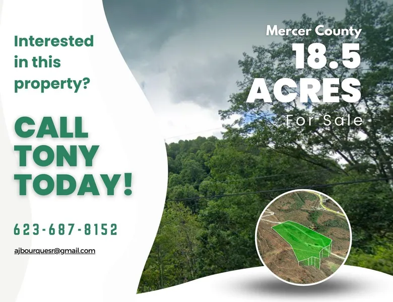
County: Mercer County
State: West Virginia
Parcel Size: 18.5 acres
Legal Description: 18 AC 80 FR LITTLE FK RDG
Land Use: VACANT
Property Type: RESIDENTIAL ACREAGE
GPS Center Coordinates: 37.436300, -81.249600
GPS Coordinates (Corners):
37.4353, -81.2509
37.4352, -81.2504
37.4352, -81.2502
37.4351, -81.2501
37.4349, -81.25
37.4352, -81.2497
37.4353, -81.2494
37.4353, -81.2489
37.4355, -81.2485
37.4375, -81.249
37.438, -81.2493
37.438, -81.2505
37.4363, -81.2505
Tax Amount: $47.58
From elevation to risk assessment
Search for detailed parcel information including; Elevation & Vegetation Maps, Ownership Information, Detailed Parcel Information, Crop History Map, Soil Survey Productivity Data, and more.
Research Parcel InformationEnvironmental Factors
Land for Sale by Anthony and Cheryl Bourque
Mercer County Properties By Type
- Farms for Sale in Mercer County, West Virginia
- Residential Property for Sale in Mercer County, West Virginia
- Undeveloped Land for Sale in Mercer County, West Virginia
- Commercial Property for Sale in Mercer County, West Virginia
- Lakefront Property for Sale in Mercer County, West Virginia
- Hunting Land for Sale in Mercer County, West Virginia
- Recreational Property for Sale in Mercer County, West Virginia
- Timberland for Sale in Mercer County, West Virginia
- Horse Property for Sale in Mercer County, West Virginia
- Ranches for Sale in Mercer County, West Virginia
- Beachfront Property for Sale in Mercer County, West Virginia
- Riverfront Property for Sale in Mercer County, West Virginia
Properties for Sale Nearby Counties
Mercer County Properties By City
- Athens, West Virginia Land for Sale
- Beeson, West Virginia Land for Sale
- Bluefield, West Virginia Land for Sale
- Bramwell, West Virginia Land for Sale
- Flat Top, West Virginia Land for Sale
- Freeman, West Virginia Land for Sale
- Hiawatha, West Virginia Land for Sale
- Kegley, West Virginia Land for Sale
- Kellysville, West Virginia Land for Sale
- Lashmeet, West Virginia Land for Sale
- Lerona, West Virginia Land for Sale
- Matoaka, West Virginia Land for Sale
- More
- Montcalm, West Virginia Land for Sale
- Nemours, West Virginia Land for Sale
- Oakvale, West Virginia Land for Sale
- Princeton, West Virginia Land for Sale
- Rock, West Virginia Land for Sale
- Spanishburg, West Virginia Land for Sale
- Wolfe, West Virginia Land for Sale
- Ada, West Virginia Land for Sale
- Bluewell, West Virginia Land for Sale
- Brush Fork, West Virginia Land for Sale
- Ceres, West Virginia Land for Sale
- Coaldale, West Virginia Land for Sale
- Dott, West Virginia Land for Sale
- Duhring, West Virginia Land for Sale
- Elgood, West Virginia Land for Sale
- Giatto, West Virginia Land for Sale
- Green Valley, West Virginia Land for Sale
- Littlesburg, West Virginia Land for Sale
- Lorton Lick, West Virginia Land for Sale
- Sandlick, West Virginia Land for Sale
- Arista, West Virginia Land for Sale
- Bluestone, West Virginia Land for Sale
- Cashers Hill, West Virginia Land for Sale
- Coopers, West Virginia Land for Sale
- Cumberland Heights, West Virginia Land for Sale
- Dunns, West Virginia Land for Sale
- Eads Mill, West Virginia Land for Sale
- Edison, West Virginia Land for Sale
- Egeria, West Virginia Land for Sale
- Flipping, West Virginia Land for Sale
- Gardner Junction, West Virginia Land for Sale
- Godfrey, West Virginia Land for Sale
- Goodwill, West Virginia Land for Sale
- Hardy, West Virginia Land for Sale
- Ingleside, West Virginia Land for Sale
- Johnston Town, West Virginia Land for Sale
- Kale, West Virginia Land for Sale
- Lake Shawnee, West Virginia Land for Sale
- Lamar, West Virginia Land for Sale
- Lilly Grove, West Virginia Land for Sale
- Maple Acre, West Virginia Land for Sale
- Maple View, West Virginia Land for Sale
- McComas, West Virginia Land for Sale
- Melrose, West Virginia Land for Sale
- New Hope, West Virginia Land for Sale
- Oak Grove, West Virginia Land for Sale
- Pettry, West Virginia Land for Sale
- Pinoak, West Virginia Land for Sale
- Shinbrier, West Virginia Land for Sale
- Simmons, West Virginia Land for Sale
- Smokeless, West Virginia Land for Sale
- South Bluefield, West Virginia Land for Sale
- Speedway, West Virginia Land for Sale
- Springton, West Virginia Land for Sale
- Wenonah, West Virginia Land for Sale
- Weyanoke, West Virginia Land for Sale
- Willowton, West Virginia Land for Sale
- Camp Creek, West Virginia Land for Sale