California Redding Downtown 0.27 Acres Homesite with ALL Utilities
Payment Plan: $600 Down, then $395 per month for 5 years
OR
Cash Price: $24300. We cover all documentation fees, filing fees, and closing costs if closing with us.
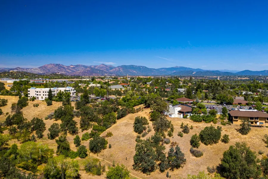
Rural Open Space Living + Urban Amenities! This wooded secluded residential land is located 3 minutes from Redding Down Town Central Business District. All Unities are available Electric, Water, Sewer, Phone, Internet. Easy access to nearby Walmart, grocery stores, schools, medical centers. Very close to the beautiful Sacramento River and Cascade Mountains. Surrounded by 7 national forests many activities in the surrounding area skiing, hiking, fishing, mountain climbing! A great place for a home or to relax. Redding Municipal Airport takes you to San Francisco in 1 hour, and to Los Angeles in 1 hour 45 minutes!
ID: CA_Redding11
State: California
County: Shasta County
Address: 2853 Olive Avenue, Redding, CA 96001
Size: 0.27 Acres
GPS: 40.56887, -122.39892
Parcel Number: 104-470-011-000
Title: Free & Clear, Grant Deed
Zoning: Residential
Altitude: 630 feet
Terrain: Gentle upward slope
Taxes: $26 per year
HOA: None
Road: County Road
Electric: City Electric
Water: City Water
Sewer: City Sewer
Phone: Cell or Landline
Internet: DSL, Cable Mode, Satellite
Redding is the county seat of Shasta County, California. Located in the northern part of California, it lies along the Sacramento River, 162 miles (261 kilometers) north of Sacramento. The city is located at the very northwestern end of the Central Valley, at the foothills of Cascade Mountains. The city is surrounded by mountains to the north, east, and west and fertile farm land to the south. Outermost parts of the city are part of the Cascade foothills, whereas southern and central areas are in the Sacramento Valley. Interstate 5 bisects the entire city from the south to north. Shasta Lake is located 15 miles (24 km) to the north. The 2010 population was 89,861.
Redding is located at the very northwestern end of the Central Valley, at the foothills of Cascade Mountains. The city is surrounded by mountains to the north, east, and west and fertile farm land to the south. Outermost parts of the city are part of the Cascade foothills, whereas southern and central areas are in the Sacramento Valley.
Surrounded by multiple national forests:
Shasta-Trinity National Forests are federally designated forests and are the largest National Forest in California. The 2.2 million acre encompasses five wilderness areas, hundreds of mountain lakes and 6,278 miles (10,103 km) of streams and rivers. Major features include Shasta Lake, the largest man-made lake in California and Mount Shasta, elevation 14,179 feet (4,322 m). The Shasta-Trinity National Forests offer a wide range of recreational activities. Some of these include hiking, backpacking, mountain climbing, horseback riding, camping, boating, fishing, hunting, sightseeing, downhill skiing and riding, snowboarding, cross-country skiing, and snowmobiling. (Website)
Six Rivers National Forest is a U.S. National Forest located in the northwestern corner of California. Its over one million acres (4,000 km2) of land contain a variety of ecosystems and 137,000 acres (550 km2) of old growth forest. The forest is named after the Eel, Van Duzen, Klamath, Trinity, Mad, and Smith rivers, which pass through or near the forests boundaries. The forest has 366 miles (589 km) of wild and scenic rivers, six distinct botanical areas, and public-use areas for camping, hiking, and fishing. (Website)
Klamath National Forest is a 1.7 million acre (2,715 sq mi; 7,033 km2) national forest, in the Klamath Mountains. The forest contains continuous stands of ponderosa pine, Jeffrey pine, Douglas fir, red fir, white fir and incense cedar. This park includes the Kangaroo Lake and the Sawyers Bar Catholic Church is located within the boundaries of the Forest. (Website)
Modoc National Forest is a 1.6 million acre (6,695 km2) national forest in northeastern California. Due to the elevation and precipitation differences, the forests hosts a large number of plant species. The western side of the brushy foothills consist mostly of bitterbrush and curl-leaf mahogany. As elevation increases, forests of ponderosa pine, white and red firs, incense cedar, and aspen give way to lodgepole and western white pines sprinkle towards the summit. (Website)
Shopping Centers:
Cobblestone Shopping Center
Cypress Square Shopping Center
Mt. Shasta Mall
Museums, Arts and Public Buildings:
Calatrava Sculpture
Sculpture park at City Hall
Sundial Bridge at Turtle Bay
Shasta Historical Society
Carnegie Library
Pilgrim Congregational Church
Sundial Bridge
The Cascade Theater
Redding Civic Auditorium
Riverfront Amphitheater
Old City Hall
Riverfront Playhouse
Redding Improv Players
College and Universities:
Shasta College
Simpson University
Shasta Bible College and Graduate School
Redding Institute of Technology
Shasta School of Cosmetology
High Schools:
Shasta High School
Enterprise High School
Foothill High School
Pioneer High School
Freedom High School
University Preparatory School
North State Independence High School
Redding Christian High School
Liberty Christian High School
Charter Schools:
Monarch Learning Center
Stellar Charter School
Redding Collegiate Academy
Redding School of the Arts
Rocky Point Charter School
Shasta Charter Academy
Redding Adventist Academy
Bethel Christian School
No HOA, HOA Fees, or Time Limit to Build
Mobile Home: that is 10 years or less is OK. Need to be fixed on a solid foundation. Roof of mobile home is able to sustain 25 pounds of snow per square feet.
RV Living during construction period (with a valid building permit) is allowed for the duration of the building permit, up to 2 years.
Single Family Home: maximum high not to exceed 25 feet. There is no minimum size requirement, but need to comply with City of Redding Building Code. Previously City of Redding had approved 200 square feet tiny homes that comply with local building code.
Building Requirement can be obtained from City of Redding Permit Center
777 Cypress Avenue, First Floor, Redding, CA 96001 Phone: 530-225-4030 (Website)
Electricity Lines & Poles are located at the road and nearby the lot, by Redding Electric Utility
3611 Avtech Parkway, Redding, CA 96002 Phone: 530-339-7200 (Website)
Water is serviced by City of Redding Public Works Water Department
20055 Viking Way, Bldg #3, Redding CA 96003 Phone: 530-224-6068 (Website)
Sewer is by City of Redding Public Works Waste Water Department
20055 Viking Way, Bldg #3, Redding CA 96003 Phone: 530-224-6068 (Website)
Trash Service is by City of Redding Public Works Solid Waste Department for $22.36/month for a 45-galleon cart
14095 Clear Creek Road, Redding, CA 96047 Phone: 530-224-6201 (Website)
Internet Service Providers
AT&T, DSL & Fiber, up to 1000 Mbps (Website)
Spectrum, Cable, up to 100 Mbps (Website)
Viasat, Satellite, up to 25 Mbps (Website)
Distance to Nearby Cities & Points of Interest:
3 minutes to Redding CBD Central Business District (more info)
10 minutes to Riverview Country Club
17 minutes to Redding Municipal Airport with multiple daily flights to San Francisco and Los Angeles
10 minutes to Win-River Resort & Casino
12 minutes to Walmart Supercenter
4 minutes to Mercy Medical Center Redding
2 minutes to Munchkin University
5 minutes to Shasta Public Libraries
10 minutes to Sacramento River Park Marina Village
2 hour 23 minutes to Sacramento, capital of California, population 508,529 (more info)
1 hour by plane to San Francisco, population 4.7 million (more info)
1 hour 45 minutes by plane to Los Angeles, population 13 million (more info)
How to Find the Land:
To best help you find the property and any of the boundary line corners, copy and paste any of these GPS coordinates into Google Maps on your computer or smartphone with your GPS turned on:
Northeast Corner: 40.56902, -122.39874
Northwest Corner: 40.56899, -122.39918
Southwest Corner: 40.56873, -122.39914
Southeast Corner: 40.56876, -122.3987
For example: copy and paste 40.56876, -122.3987 (with the comma and the dash) into the search bar in Google Maps to find the exact location. We recommend this method as the best way to locate the property because the land will be unmarked with no signs or survey stakes.
City of Redding put an entrance gate on Linden Avenue, to prevent unauthorized access. It allows owners to drive in. If you visit, buyers can feel free to park the car on Linden Ave, and walk inside to check out the land. There is a photo showing the entrance gate.
How to arrange a visit to the property?
You are welcome to visit a property anytime you like. Just Contact Us to schedule a time so that we can be sure the property is still available before you drive out to it. We operate an eCommerce land business, and we typically do not accompany property visits.
From elevation to risk assessment
Search for detailed parcel information including; Elevation & Vegetation Maps, Ownership Information, Detailed Parcel Information, Crop History Map, Soil Survey Productivity Data, and more.
Research Parcel InformationDirections
Address: 2853 Olive Avenue, Redding, CA 96001
GPS: 40.56887, -122.39892
Resources
Land for Sale by Elegment Land
Shasta County Properties By Type
- Ranches for Sale in Shasta County, California
- Undeveloped Land for Sale in Shasta County, California
- Lakefront Property for Sale in Shasta County, California
- Farms for Sale in Shasta County, California
- Residential Property for Sale in Shasta County, California
- Riverfront Property for Sale in Shasta County, California
- Recreational Property for Sale in Shasta County, California
- Hunting Land for Sale in Shasta County, California
- Commercial Property for Sale in Shasta County, California
- Timberland for Sale in Shasta County, California
- Horse Property for Sale in Shasta County, California
- Beachfront Property for Sale in Shasta County, California
Properties for Sale Nearby Counties
Shasta County Properties By City
- Anderson, California Land for Sale
- Bella Vista, California Land for Sale
- Big Bend, California Land for Sale
- Burney, California Land for Sale
- Cassel, California Land for Sale
- Castella, California Land for Sale
- Fall River Mills, California Land for Sale
- French Gulch, California Land for Sale
- Hat Creek, California Land for Sale
- Igo, California Land for Sale
- Lakehead, California Land for Sale
- Mcarthur, California Land for Sale
- More
- Millville, California Land for Sale
- Montgomery Creek, California Land for Sale
- Oak Run, California Land for Sale
- Old Station, California Land for Sale
- Palo Cedro, California Land for Sale
- Platina, California Land for Sale
- Redding, California Land for Sale
- Round Mountain, California Land for Sale
- Shasta, California Land for Sale
- Shasta Lake, California Land for Sale
- Shingletown, California Land for Sale
- Whiskeytown, California Land for Sale
- Whitmore, California Land for Sale
- Centerville, California Land for Sale
- Four Corners, California Land for Sale
- Johnson Park, California Land for Sale
- Keswick, California Land for Sale
- Pittville, California Land for Sale
- Viola, California Land for Sale
- Wildwood, California Land for Sale
- Antlers, California Land for Sale
- Bateman Place, California Land for Sale
- Beal Place, California Land for Sale
- Buckeye, California Land for Sale
- Bully Hill, California Land for Sale
- Castle Crag, California Land for Sale
- Cayton, California Land for Sale
- Conant, California Land for Sale
- Coram, California Land for Sale
- Dana, California Land for Sale
- Dirigo, California Land for Sale
- Doyles Corner, California Land for Sale
- Eastman Place, California Land for Sale
- Enterprise, California Land for Sale
- Fern, California Land for Sale
- Frazier Corners, California Land for Sale
- Gas Point, California Land for Sale
- Gibson, California Land for Sale
- Girvan, California Land for Sale
- Gomez, California Land for Sale
- Government Camp, California Land for Sale
- Harlow Place, California Land for Sale
- Ingot, California Land for Sale
- Inwood, California Land for Sale
- Iron Mountain, California Land for Sale
- Kett, California Land for Sale
- Knob, California Land for Sale
- Lamoine, California Land for Sale
- Loomis Corners, California Land for Sale
- Manzanita Lake, California Land for Sale
- Matheson, California Land for Sale
- McColl, California Land for Sale
- Minnesota, California Land for Sale
- Motion, California Land for Sale
- Mountain Gate, California Land for Sale
- Obie, California Land for Sale
- O'Brien, California Land for Sale
- Ono, California Land for Sale
- Osborne, California Land for Sale
- Paige Bar, California Land for Sale
- Pawnee, California Land for Sale
- Point McCloud, California Land for Sale
- Pollard Flat, California Land for Sale
- Pollock, California Land for Sale
- Portal Inn, California Land for Sale
- Redwoods, California Land for Sale
- Rinckel, California Land for Sale
- Riverview, California Land for Sale
- Sherman, California Land for Sale
- Silverthorn, California Land for Sale
- Sims, California Land for Sale
- Smith, California Land for Sale
- Spalding Corner, California Land for Sale
- Summertown, California Land for Sale
- Sweetbriar, California Land for Sale
- Tunnel Inn, California Land for Sale
- Vollmers, California Land for Sale
- Wagoner, California Land for Sale
- Wengler, California Land for Sale
- Whittington Place, California Land for Sale
- Wilkinson, California Land for Sale