11.4 Acres - Marion County
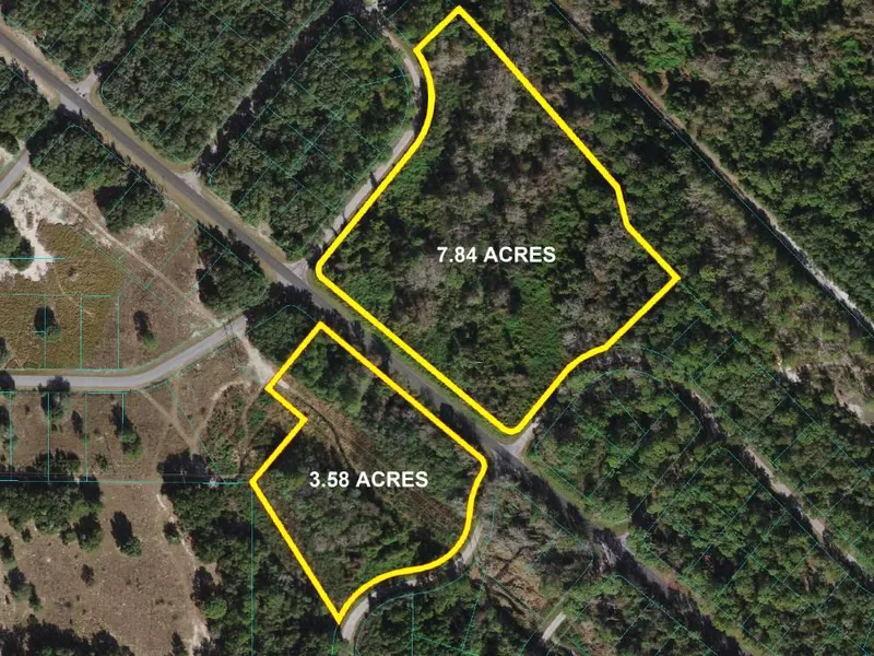
Looking for a larger property in a great location? Two parcels being sold together for a total of 11.4 acres of land. The first parcel (parcel id 9051-0000-04) is 7.84 acres, is zoned RE and according to the county the is buildable. The second parcel (parcel id 9051-0000-03) is located across Locust Rd and is 3.58 acres, zoned RE and has wetlands according to the county. Both are located in Flood Zone A so some site work may be desired or needed. Only 30 minutes to Ocala, 12 minutes to Lake Weir, and 30 minutes to Ocala National Forest. GPS coordinates: 29.078047, -81.958757. Call for more information.
COUNTY: Marion FL
ADDRESS: Locust Rd Ocklawaha, FL 32179
PARCEL ID: 9051-0000-03 & 9051-0000-04
GPS: 29.078047, -81.958757
ACRES: 11.42 acres total - 3.58 acres (90510000-03) 7.84 acres (90510000-04)
ZONING: RE (low density)
FLOOD ZONE: A
WATER: Would be by well
WASTE WATER: Would be by septic tank or alternative
POWER: Nearby
From elevation to risk assessment
Search for detailed parcel information including; Elevation & Vegetation Maps, Ownership Information, Detailed Parcel Information, Crop History Map, Soil Survey Productivity Data, and more.
Research Parcel InformationEnvironmental Factors
More Land for Sale in Marion County
Marion County Properties By Type
- Undeveloped Land for Sale in Marion County, Florida
- Farms for Sale in Marion County, Florida
- Residential Property for Sale in Marion County, Florida
- Lakefront Property for Sale in Marion County, Florida
- Ranches for Sale in Marion County, Florida
- Riverfront Property for Sale in Marion County, Florida
- Beachfront Property for Sale in Marion County, Florida
- Horse Property for Sale in Marion County, Florida
- Recreational Property for Sale in Marion County, Florida
- Commercial Property for Sale in Marion County, Florida
- Hunting Land for Sale in Marion County, Florida
- Timberland for Sale in Marion County, Florida
Properties for Sale Nearby Counties
Marion County Properties By City
- Anthony, Florida Land for Sale
- Belleview, Florida Land for Sale
- Candler, Florida Land for Sale
- Citra, Florida Land for Sale
- Dunnellon, Florida Land for Sale
- Fairfield, Florida Land for Sale
- Lowell, Florida Land for Sale
- Ocala, Florida Land for Sale
- Ocklawaha, Florida Land for Sale
- Orange Lake, Florida Land for Sale
- Orange Springs, Florida Land for Sale
- Reddick, Florida Land for Sale
- More
- Silver Springs, Florida Land for Sale
- Sparr, Florida Land for Sale
- Summerfield, Florida Land for Sale
- Weirsdale, Florida Land for Sale
- Flemington, Florida Land for Sale
- Irvine, Florida Land for Sale
- Maricamp, Florida Land for Sale
- Salt Springs, Florida Land for Sale
- Bahia Oaks, Florida Land for Sale
- Belleview Heights, Florida Land for Sale
- Big Scrub, Florida Land for Sale
- Blitchton, Florida Land for Sale
- Boardman, Florida Land for Sale
- Bruceville, Florida Land for Sale
- Burbank, Florida Land for Sale
- Camp Roosevelt, Florida Land for Sale
- Cara, Florida Land for Sale
- Cedar Creek, Florida Land for Sale
- Chatmire, Florida Land for Sale
- Conner, Florida Land for Sale
- Cotton Plant, Florida Land for Sale
- Dallas, Florida Land for Sale
- Danks Corner, Florida Land for Sale
- Early Bird, Florida Land for Sale
- East Lake Weir, Florida Land for Sale
- East Silver Springs Shore, Florida Land for Sale
- Electra, Florida Land for Sale
- Emathla, Florida Land for Sale
- Fellowship, Florida Land for Sale
- Forest Corners, Florida Land for Sale
- Forest Lakes Park, Florida Land for Sale
- Fort Drane, Florida Land for Sale
- Fort McCoy, Florida Land for Sale
- Golden Hills, Florida Land for Sale
- Grahamsville, Florida Land for Sale
- Hog Valley, Florida Land for Sale
- Hoyt, Florida Land for Sale
- Huntington, Florida Land for Sale
- Kendrick, Florida Land for Sale
- Kerr City, Florida Land for Sale
- Lacota, Florida Land for Sale
- Lake Weir, Florida Land for Sale
- Linadale, Florida Land for Sale
- Luddersville, Florida Land for Sale
- Lynn, Florida Land for Sale
- Lynne, Florida Land for Sale
- Marion Oaks, Florida Land for Sale
- Martel, Florida Land for Sale
- McIntosh, Florida Land for Sale
- Millwood, Florida Land for Sale
- Monroes Corner, Florida Land for Sale
- Montague, Florida Land for Sale
- Moss Bluff, Florida Land for Sale
- Mount Olive, Florida Land for Sale
- Nubys Corner, Florida Land for Sale
- Oak, Florida Land for Sale
- Ocala Park Ranch, Florida Land for Sale
- Ocala Ridge, Florida Land for Sale
- Ocala Thoroughbred Acres, Florida Land for Sale
- Ocala Waterway, Florida Land for Sale
- Orange Blossom Hills, Florida Land for Sale
- Pedro, Florida Land for Sale
- Point Pleasant, Florida Land for Sale
- Rainbow Falls, Florida Land for Sale
- Rainbow Park, Florida Land for Sale
- Regal Park, Florida Land for Sale
- Rocksprings, Florida Land for Sale
- Rolling Hills, Florida Land for Sale
- Rolling Ranches, Florida Land for Sale
- Romeo, Florida Land for Sale
- Ross Prairie, Florida Land for Sale
- Saddle Oak Club, Florida Land for Sale
- Santos, Florida Land for Sale
- Shady, Florida Land for Sale
- Sherman Oaks, Florida Land for Sale
- Silver Springs Shores, Florida Land for Sale
- South Side, Florida Land for Sale
- Stanton, Florida Land for Sale
- Starkes Ferry, Florida Land for Sale
- Sunset Harbor, Florida Land for Sale
- Tobacco Patch Landing, Florida Land for Sale
- Woods and Lakes, Florida Land for Sale
- Yellow Bluff, Florida Land for Sale
- York, Florida Land for Sale
- Zuber, Florida Land for Sale