5 Acres In Oxford County With Driveway And Views
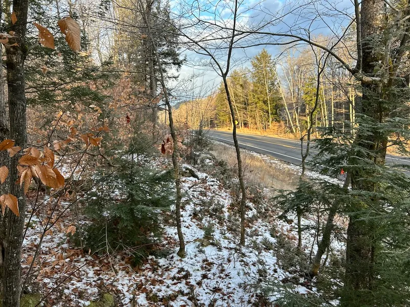
This 5-acre Oxford County parcel offers convenient access, elevation, and a setting suited for either a seasonal camp or a future year-round home. The land fronts directly on Route 26, making arrival easy in all seasons. A driveway is already in place, providing a clear starting point for site planning and walk-in access.The land sits above the highway, which provides a sense of separation and the potential for views north toward the surrounding hills. Depending on your final building height and orientation, you may also enjoy seasonal or partial views of Bryant Pond, a well-known local body of water. The elevation gives you a range of vantage points to work with as you walk the property.Several naturally flat spots offer possible building areas without requiring major groundwork. Much of the land has a gentle rise, giving structure without being difficult to navigate. Neighboring properties have been surveyed, which can aid in orientation, even if this parcel has not yet been formally surveyed.This location places you near skiing, hiking, lakes, and the broader Western Maine foothills. Whether you’re imagining a simple base camp, a small cabin site, or a year-round home as conditions allow, this tract offers flexibility without overpromising outcomes.Walk the driveway and explore the upper benches to see your options.Request the map and parcel sketch before your visit so that you can plan your approach.If you’ve been searching for accessible land with elevation and potential views, this parcel is worth considering.
From elevation to risk assessment
Search for detailed parcel information including; Elevation & Vegetation Maps, Ownership Information, Detailed Parcel Information, Crop History Map, Soil Survey Productivity Data, and more.
Research Parcel InformationDirections
GPS coords 44.3968, -70.6697 on ME Hwy 26
Resources
Land for Sale by Shane Patrick
Oxford County Properties By Type
- Lakefront Property for Sale in Oxford County, Maine
- Undeveloped Land for Sale in Oxford County, Maine
- Riverfront Property for Sale in Oxford County, Maine
- Residential Property for Sale in Oxford County, Maine
- Farms for Sale in Oxford County, Maine
- Commercial Property for Sale in Oxford County, Maine
- Hunting Land for Sale in Oxford County, Maine
- Ranches for Sale in Oxford County, Maine
- Recreational Property for Sale in Oxford County, Maine
- Timberland for Sale in Oxford County, Maine
- Horse Property for Sale in Oxford County, Maine
- Beachfront Property for Sale in Oxford County, Maine
Properties for Sale Nearby Counties
Oxford County Properties By City
- Andover, Maine Land for Sale
- Bethel, Maine Land for Sale
- Brownfield, Maine Land for Sale
- Bryant Pond, Maine Land for Sale
- Buckfield, Maine Land for Sale
- Canton, Maine Land for Sale
- Center Lovell, Maine Land for Sale
- Denmark, Maine Land for Sale
- Dixfield, Maine Land for Sale
- East Andover, Maine Land for Sale
- Fryeburg, Maine Land for Sale
- Greenwood, Maine Land for Sale
- More
- Hanover, Maine Land for Sale
- Hebron, Maine Land for Sale
- Hiram, Maine Land for Sale
- Lovell, Maine Land for Sale
- Mexico, Maine Land for Sale
- Newry, Maine Land for Sale
- North Waterford, Maine Land for Sale
- Norway, Maine Land for Sale
- Oxford, Maine Land for Sale
- Paris, Maine Land for Sale
- Peru, Maine Land for Sale
- Porter, Maine Land for Sale
- Roxbury, Maine Land for Sale
- Rumford, Maine Land for Sale
- South Paris, Maine Land for Sale
- Sumner, Maine Land for Sale
- West Bethel, Maine Land for Sale
- West Paris, Maine Land for Sale
- Byron, Maine Land for Sale
- Carthage, Maine Land for Sale
- Frye, Maine Land for Sale
- Gilead, Maine Land for Sale
- Hartford, Maine Land for Sale
- North Fryeburg, Maine Land for Sale
- Rumford Center, Maine Land for Sale
- Rumford Point, Maine Land for Sale
- South Waterford, Maine Land for Sale
- Stow, Maine Land for Sale
- Upton, Maine Land for Sale
- West Peru, Maine Land for Sale
- Woodstock, Maine Land for Sale
- Abbotts Mill, Maine Land for Sale
- Brickett Place, Maine Land for Sale
- Brimstone Corner, Maine Land for Sale
- Caldwell Corner, Maine Land for Sale
- Canton Point, Maine Land for Sale
- Chambers Corner, Maine Land for Sale
- Cobb Cove, Maine Land for Sale
- Coos Canyon, Maine Land for Sale
- Dickvale, Maine Land for Sale
- Dixfield Center, Maine Land for Sale
- Dunkertown, Maine Land for Sale
- Durgintown, Maine Land for Sale
- East Bethel, Maine Land for Sale
- East Brownfield, Maine Land for Sale
- East Buckfield, Maine Land for Sale
- East Fryeburg, Maine Land for Sale
- East Hiram, Maine Land for Sale
- East Milton, Maine Land for Sale
- East Otisfield, Maine Land for Sale
- East Peru, Maine Land for Sale
- East Stoneham, Maine Land for Sale
- East Sumner, Maine Land for Sale
- East Sweden, Maine Land for Sale
- East Waterford, Maine Land for Sale
- Fryeburg Center, Maine Land for Sale
- Gilbertville, Maine Land for Sale
- Hale, Maine Land for Sale
- Hastings, Maine Land for Sale
- Heads Corner, Maine Land for Sale
- Highland Park, Maine Land for Sale
- Houghton, Maine Land for Sale
- Hunts Corner, Maine Land for Sale
- Ketchum, Maine Land for Sale
- Liberty Corner, Maine Land for Sale
- Locke Mills, Maine Land for Sale
- Lynchville, Maine Land for Sale
- Mayville, Maine Land for Sale
- Meadowview, Maine Land for Sale
- Merrill Corner, Maine Land for Sale
- Middle Dam, Maine Land for Sale
- Middle Intervale, Maine Land for Sale
- Milton, Maine Land for Sale
- New Boston, Maine Land for Sale
- Nobles Corner, Maine Land for Sale
- North Bethel, Maine Land for Sale
- North Buckfield, Maine Land for Sale
- North Lovell, Maine Land for Sale
- North Newry, Maine Land for Sale
- North Norway, Maine Land for Sale
- North Paris, Maine Land for Sale
- North Woodstock, Maine Land for Sale
- Northwest Bethel, Maine Land for Sale
- Norway Center, Maine Land for Sale
- Norway Lake, Maine Land for Sale
- Otisfield Gore, Maine Land for Sale
- Oxford Station, Maine Land for Sale
- Paine Corner, Maine Land for Sale
- Pleasant Island, Maine Land for Sale
- Porterfield, Maine Land for Sale
- Pratt Corner, Maine Land for Sale
- Rankins Mill, Maine Land for Sale
- Rayville, Maine Land for Sale
- Redding, Maine Land for Sale
- Ridlonville, Maine Land for Sale
- Rumford Corner, Maine Land for Sale
- Slab City, Maine Land for Sale
- Smith Crossing, Maine Land for Sale
- Sodom, Maine Land for Sale
- South Andover, Maine Land for Sale
- South Arm, Maine Land for Sale
- South Hiram, Maine Land for Sale
- South Rumford, Maine Land for Sale
- South Woodstock, Maine Land for Sale
- Spurrs Corner, Maine Land for Sale
- Trap Corner, Maine Land for Sale
- Upper Dam, Maine Land for Sale
- Virginia, Maine Land for Sale
- Waterford Flat, Maine Land for Sale
- Welchville, Maine Land for Sale
- West Brownfield, Maine Land for Sale
- West Denmark, Maine Land for Sale
- West Fryeburg, Maine Land for Sale
- West Sumner, Maine Land for Sale
- Willis Mill, Maine Land for Sale
- Wilsons Mills, Maine Land for Sale
- Worthley Pond, Maine Land for Sale
- Wright Corner, Maine Land for Sale
- Yagger, Maine Land for Sale
- Waterford, Maine Land for Sale
- Otisfield, Maine Land for Sale
- Lynchtown Township, Maine Land for Sale
- Merrill, Maine Land for Sale
