Peaceful Retreat Near Upper Red Lake – 6 Acres in Beltrami County
$49,999 cash or $59,999 with owner financing
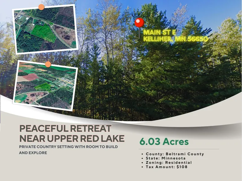
Escape to the beauty of northern Minnesota with this 6.03-acre property located on Main St E in Kelliher. This spacious lot offers the perfect balance of privacy and accessibility, giving you the freedom to create your dream retreat or build a future residence surrounded by the tranquility of nature.
Just 6 miles from downtown Kelliher, you’ll find small-town conveniences including dining, shops, and local services. For larger-city amenities, Bemidji is 41 miles south, offering entertainment, hospitals, and a regional airport. Outdoor enthusiasts will love the proximity to Upper Red Lake, only 12 miles away, one of Minnesota’s premier fishing and boating destinations. The Chippewa National Forest, with its extensive hiking, camping, and wildlife opportunities, is also just minutes from the property.
Owning land in Beltrami County means access to some of the state’s best recreational opportunities year-round, from fishing and hunting to snowmobiling and cross-country skiing. With low property taxes, natural beauty, and a prime location near lakes and forests, this parcel offers both lifestyle and investment value.
Property Details:
Parcel #: 83.00019.00
Property Address: Main St E, Kelliher, MN 56650
County: Beltrami County
State: Minnesota
Parcel Size: 6.03 Acres
Legal Description: Sect 35 Twp 152 Range 030 6.03 Ac Se1/4 Of Ne1/4 Lying S Of N'rly Bndry Of Csah 36,As Relocate In 1953 & Reconstruct In 1961,Less 3 Tracts Desc As Follows: 1)commence At Sw Corner Of Said Se1/4 Of Ne1/4; Thence N0*12'31"E,Assumed Bearing Along W Line
Land Use: Residential (Nec)
Property Type: Single Family Residence
GPS Center Coordinates: 47.94092, -94.44263
GPS Coordinates (Corners):
47.940261, -94.443833
47.941182, -94.443837
47.941183, -94.443540
47.941239, -94.443541
47.941248, -94.442929
47.941604, -94.442931
47.940722, -94.440985
47.940290, -94.440985
Tax Amount: $108
From elevation to risk assessment
Search for detailed parcel information including; Elevation & Vegetation Maps, Ownership Information, Detailed Parcel Information, Crop History Map, Soil Survey Productivity Data, and more.
Research Parcel InformationDirections
Beltrami County Properties By Type
- Farms for Sale in Beltrami County, Minnesota
- Undeveloped Land for Sale in Beltrami County, Minnesota
- Hunting Land for Sale in Beltrami County, Minnesota
- Lakefront Property for Sale in Beltrami County, Minnesota
- Commercial Property for Sale in Beltrami County, Minnesota
- Residential Property for Sale in Beltrami County, Minnesota
- Timberland for Sale in Beltrami County, Minnesota
- Recreational Property for Sale in Beltrami County, Minnesota
- Ranches for Sale in Beltrami County, Minnesota
- Horse Property for Sale in Beltrami County, Minnesota
- Beachfront Property for Sale in Beltrami County, Minnesota
- Riverfront Property for Sale in Beltrami County, Minnesota
Properties for Sale Nearby Counties
- Cass County, Minnesota Land for Sale
- Clearwater County, Minnesota Land for Sale
- Hubbard County, Minnesota Land for Sale
- Itasca County, Minnesota Land for Sale
- Koochiching County, Minnesota Land for Sale
- Lake of the Woods County, Minnesota Land for Sale
- Marshall County, Minnesota Land for Sale
- Pennington County, Minnesota Land for Sale
- Roseau County, Minnesota Land for Sale
Beltrami County Properties By City
- Bemidji, Minnesota Land for Sale
- Blackduck, Minnesota Land for Sale
- Grygla, Minnesota Land for Sale
- Hines, Minnesota Land for Sale
- Kelliher, Minnesota Land for Sale
- Pennington, Minnesota Land for Sale
- Ponemah, Minnesota Land for Sale
- Puposky, Minnesota Land for Sale
- Redby, Minnesota Land for Sale
- Solway, Minnesota Land for Sale
- Tenstrike, Minnesota Land for Sale
- Waskish, Minnesota Land for Sale
- More
- Wilton, Minnesota Land for Sale
- Becida, Minnesota Land for Sale
- Funkley, Minnesota Land for Sale
- Langor, Minnesota Land for Sale
- Nebish, Minnesota Land for Sale
- Quiring, Minnesota Land for Sale
- Saum, Minnesota Land for Sale
- Shooks, Minnesota Land for Sale
- Shotley, Minnesota Land for Sale
- Turtle River, Minnesota Land for Sale
- Andrusia, Minnesota Land for Sale
- Aure, Minnesota Land for Sale
- Birchmont, Minnesota Land for Sale
- Carmel, Minnesota Land for Sale
- Country Lane Manufactured Home Park, Minnesota Land for Sale
- Debs, Minnesota Land for Sale
- Domaas, Minnesota Land for Sale
- Four Town, Minnesota Land for Sale
- Gates Corner, Minnesota Land for Sale
- Gene Moen Manufactured Home Park, Minnesota Land for Sale
- Inez, Minnesota Land for Sale
- Island Lake, Minnesota Land for Sale
- Jelle, Minnesota Land for Sale
- Little Rock, Minnesota Land for Sale
- Malcolm, Minnesota Land for Sale
- Norway Park, Minnesota Land for Sale
- Otto, Minnesota Land for Sale
- Red Lake, Minnesota Land for Sale
- Rosby, Minnesota Land for Sale
- Scribner, Minnesota Land for Sale
- Secluded Acres, Minnesota Land for Sale
- Thorhult, Minnesota Land for Sale
- Werner, Minnesota Land for Sale