20 Acre Recreational Lot in Elko County, NV
Seller financing available for just $1999 down!
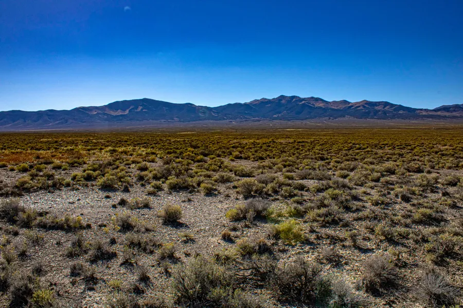
Looking for a life off the grid? Bring your RV to this 20-acre desert property. It has all the space and privacy youll want for your outdoor adventure with a stunning backdrop. Camp your RV, bring your OHV, discover wildlife or build the ranch life youve dreamed about for years. With gorgeous views of the Murdock Mountain, you cant beat this outdoor recreational escape thats all your own. The property borders public land so youll have even more space to explore.
While youll love that this rural northern Nevada property is free from crowds, dont think youll be far from opportunity. The nearby Ruby Mountains and Spruce Mountains are a playground for mountain climbing, hiking, biking, running, skiing, snowmobiling and fishing. With four mild seasons, Elko County offers something for every adventurer.
All of this opportunity comes with easy access to Interstate 80 and is just west of Wendover, NV and the Utah border. Visit West Wendover for the night life with casinos, steakhouses and a nod to cowboy life.
Want to learn more? We make owning your own land easy and affordable. Call us at (612)217-0757.
Size: 20 Acres
County: Elko, Nevada
APN: 010-36L-014
Zoning: Open Space
Rural Residential Building: Contact Elko County Planning and Zoning for details.
Terrain: Gently rolling
Power: Would require solar or generator
Water: Would require a well, catchment system, or holding tank
Septic/Sewer: Would require a septic/alternative
Access: Property can be accessed via a dirt road on the East that is bordering to a BLM Land.
HOA/POA: None
Annual Property Taxes: Approximately $42.02
Price
Cash Price: $15977
Seller Financing: $1999 down
$229 month (+20/month servicing fee) for 120 months
Total financed price: 29,479
Documentation Fee: $299 (for both cash and financed purchase)
PLEASE NOTE:
The buyer is responsible for verifying all property details and conducting all due diligence.
From elevation to risk assessment
Search for detailed parcel information including; Elevation & Vegetation Maps, Ownership Information, Detailed Parcel Information, Crop History Map, Soil Survey Productivity Data, and more.
Research Parcel InformationDirections
41.2223, -114.2387
Property can be accessed via a dirt road on the East that is bordering to a BLM Land.
Nearby recreational opportunities:
Pilot Peak
Blue Lake
Bonneville Salt Flats
Property Details
Resources
Land for Sale by Joe Schmitt
Elko County Properties By Type
- Undeveloped Land for Sale in Elko County, Nevada
- Ranches for Sale in Elko County, Nevada
- Residential Property for Sale in Elko County, Nevada
- Farms for Sale in Elko County, Nevada
- Hunting Land for Sale in Elko County, Nevada
- Riverfront Property for Sale in Elko County, Nevada
- Recreational Property for Sale in Elko County, Nevada
- Lakefront Property for Sale in Elko County, Nevada
- Commercial Property for Sale in Elko County, Nevada
- Horse Property for Sale in Elko County, Nevada
- Timberland for Sale in Elko County, Nevada
- Beachfront Property for Sale in Elko County, Nevada
Properties for Sale Nearby Counties
- Box Elder County, Nevada Land for Sale
- Cassia County, Nevada Land for Sale
- Eureka County, Nevada Land for Sale
- Humboldt County, Nevada Land for Sale
- Lander County, Nevada Land for Sale
- Owyhee County, Nevada Land for Sale
- Tooele County, Nevada Land for Sale
- Twin Falls County, Nevada Land for Sale
- White Pine County, Nevada Land for Sale
Elko County Properties By City
- Carlin, Nevada Land for Sale
- Deeth, Nevada Land for Sale
- Elko, Nevada Land for Sale
- Halleck, Nevada Land for Sale
- Jackpot, Nevada Land for Sale
- Jarbidge, Nevada Land for Sale
- Lamoille, Nevada Land for Sale
- Montello, Nevada Land for Sale
- Mountain City, Nevada Land for Sale
- Owyhee, Nevada Land for Sale
- Ruby Valley, Nevada Land for Sale
- Spring Creek, Nevada Land for Sale
- More
- Tuscarora, Nevada Land for Sale
- Wells, Nevada Land for Sale
- West Wendover, Nevada Land for Sale
- Arthur, Nevada Land for Sale
- Cobre, Nevada Land for Sale
- Contact, Nevada Land for Sale
- Jiggs, Nevada Land for Sale
- Lee, Nevada Land for Sale
- North Fork, Nevada Land for Sale
- Oasis, Nevada Land for Sale
- Patsville, Nevada Land for Sale
- Pequop, Nevada Land for Sale
- San Jacinto, Nevada Land for Sale
- Shafter, Nevada Land for Sale
- Wendover, Nevada Land for Sale
- Wilkins, Nevada Land for Sale
- Alazon, Nevada Land for Sale
- Brennen Ranch, Nevada Land for Sale
- Bullion, Nevada Land for Sale
- Charleston, Nevada Land for Sale
- Clifside, Nevada Land for Sale
- Coin, Nevada Land for Sale
- Decoy, Nevada Land for Sale
- Deep Creek, Nevada Land for Sale
- Delaplain, Nevada Land for Sale
- Dinner Station, Nevada Land for Sale
- Dolly Varden, Nevada Land for Sale
- Dry Creek, Nevada Land for Sale
- Eastline, Nevada Land for Sale
- Echo, Nevada Land for Sale
- Elburz, Nevada Land for Sale
- Fenelon, Nevada Land for Sale
- Henry, Nevada Land for Sale
- Hogan, Nevada Land for Sale
- Holborn, Nevada Land for Sale
- Hunter, Nevada Land for Sale
- Jack Creek, Nevada Land for Sale
- Jack Creek Camp, Nevada Land for Sale
- Loray, Nevada Land for Sale
- Melandco, Nevada Land for Sale
- Mizpah, Nevada Land for Sale
- Moleen, Nevada Land for Sale
- Moor, Nevada Land for Sale
- Ola, Nevada Land for Sale
- Old Bullion, Nevada Land for Sale
- Osino, Nevada Land for Sale
- Pilot, Nevada Land for Sale
- Point of Rocks, Nevada Land for Sale
- Proctor, Nevada Land for Sale
- Rock House, Nevada Land for Sale
- Rowland, Nevada Land for Sale
- Ryndon, Nevada Land for Sale
- Sage, Nevada Land for Sale
- Schoer Place, Nevada Land for Sale
- Scraper Springs, Nevada Land for Sale
- Shanty Town, Nevada Land for Sale
- Shores, Nevada Land for Sale
- Silver Zone, Nevada Land for Sale
- Spruce, Nevada Land for Sale
- Sprucemont, Nevada Land for Sale
- Tecoma, Nevada Land for Sale
- Tonka, Nevada Land for Sale
- Tulasco, Nevada Land for Sale
- Tyrol, Nevada Land for Sale
- Ventosa, Nevada Land for Sale
- Vivian, Nevada Land for Sale
- Welcome, Nevada Land for Sale
- Williams Cabin, Nevada Land for Sale