10 Acres in Elko County! Road Access Borders BLM $199 Monthly!
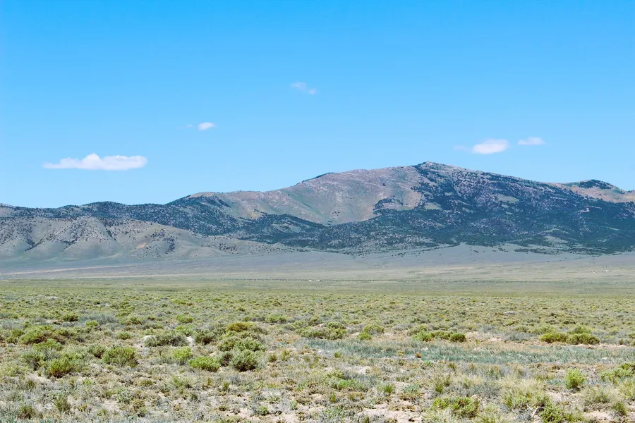
Beautiful 10 acre property located just outside of Montello. Dirt road access just off HWY 233 will make for easy winter access. No neighbors! Great access, great views and great recreation in the area. Borders BLM land on the east side.
Property Details:
Parcel Number: 010-36L-041 (24005)
Property Description: 10 Acres in Elko County, NV
Street Name: Unnamed Dirt road.
Size: 10 Acres
GPS Coordinates to Center: 41.221197, -114.239408
GPS NW Corner: 41.222094, -114.240631
GPS NE Corner: 41.222147, -114.238184
GPS SW Corner: 41.220244, -114.240631
GPS SE Corner: 41.220301, -114.238187
Elevation: 5,021 feet
County and State: Elko County, Nevada
Views From Property: Beautiful Mountain Views!
Terrain: Flat to rolling. Sage and natural grasses. Borders BLM Land!
Land Use Code: 120 Single Family Residential
Zoning Code: OS Open Space. Cannot be divided any further.
Water: A well will be needed. Water
Sewer: A septic will be needed.
Power: Solar, wind or generator.
Nearest Road: On the east side of the property
Nearest Major Freeway: 0.32 miles from HWY 233
Time Limit to Build: None
Tax Per Year: $28.38
BLM borders eastside of property, 3.43 miles from Montello, 2.10 miles from
Immigrant Creek, 3.01 miles from Montello Creek, 3.32 miles from Hoppie Creek,
11.86 miles from Dake Reservoir, 4.28 miles from Murdock Mountain, 10.95 miles
from Bald Eagle Mountain.
We have some great terms on this property!
$299 Down (Includes non-refundable $299 document fee)
$199 per month
9.99% Fixed Rate APRfully amortized
No pre-payment penalty
10% Discount off purchase price if paid off in 5 months!
30 day money back guarantee! (minus doc fee).
Total Purchase Price: $12,997.00
As always, we guarantee the property to be free from any liens or back taxes. GUARANTEED!
Please send me an email to get the complete property report with high quality photos of the property! Have a great day!
Mark #24005
From elevation to risk assessment
Search for detailed parcel information including; Elevation & Vegetation Maps, Ownership Information, Detailed Parcel Information, Crop History Map, Soil Survey Productivity Data, and more.
Research Parcel InformationDirections
Environmental Factors
Resources
Elko County Properties By Type
- Undeveloped Land for Sale in Elko County, Nevada
- Ranches for Sale in Elko County, Nevada
- Residential Property for Sale in Elko County, Nevada
- Hunting Land for Sale in Elko County, Nevada
- Recreational Property for Sale in Elko County, Nevada
- Farms for Sale in Elko County, Nevada
- Horse Property for Sale in Elko County, Nevada
- Lakefront Property for Sale in Elko County, Nevada
- Commercial Property for Sale in Elko County, Nevada
- Riverfront Property for Sale in Elko County, Nevada
- Timberland for Sale in Elko County, Nevada
- Beachfront Property for Sale in Elko County, Nevada
Properties for Sale Nearby Counties
- Box Elder County, Nevada Land for Sale
- Cassia County, Nevada Land for Sale
- Eureka County, Nevada Land for Sale
- Humboldt County, Nevada Land for Sale
- Lander County, Nevada Land for Sale
- Owyhee County, Nevada Land for Sale
- Tooele County, Nevada Land for Sale
- Twin Falls County, Nevada Land for Sale
- White Pine County, Nevada Land for Sale
Elko County Properties By City
- Carlin, Nevada Land for Sale
- Deeth, Nevada Land for Sale
- Elko, Nevada Land for Sale
- Halleck, Nevada Land for Sale
- Jackpot, Nevada Land for Sale
- Jarbidge, Nevada Land for Sale
- Lamoille, Nevada Land for Sale
- Montello, Nevada Land for Sale
- Mountain City, Nevada Land for Sale
- Owyhee, Nevada Land for Sale
- Ruby Valley, Nevada Land for Sale
- Spring Creek, Nevada Land for Sale
- More
- Tuscarora, Nevada Land for Sale
- Wells, Nevada Land for Sale
- West Wendover, Nevada Land for Sale
- Arthur, Nevada Land for Sale
- Cobre, Nevada Land for Sale
- Contact, Nevada Land for Sale
- Jiggs, Nevada Land for Sale
- Lee, Nevada Land for Sale
- North Fork, Nevada Land for Sale
- Oasis, Nevada Land for Sale
- Patsville, Nevada Land for Sale
- Pequop, Nevada Land for Sale
- San Jacinto, Nevada Land for Sale
- Shafter, Nevada Land for Sale
- Wendover, Nevada Land for Sale
- Wilkins, Nevada Land for Sale
- Alazon, Nevada Land for Sale
- Brennen Ranch, Nevada Land for Sale
- Bullion, Nevada Land for Sale
- Charleston, Nevada Land for Sale
- Clifside, Nevada Land for Sale
- Coin, Nevada Land for Sale
- Decoy, Nevada Land for Sale
- Deep Creek, Nevada Land for Sale
- Delaplain, Nevada Land for Sale
- Dinner Station, Nevada Land for Sale
- Dolly Varden, Nevada Land for Sale
- Dry Creek, Nevada Land for Sale
- Eastline, Nevada Land for Sale
- Echo, Nevada Land for Sale
- Elburz, Nevada Land for Sale
- Fenelon, Nevada Land for Sale
- Henry, Nevada Land for Sale
- Hogan, Nevada Land for Sale
- Holborn, Nevada Land for Sale
- Hunter, Nevada Land for Sale
- Jack Creek, Nevada Land for Sale
- Jack Creek Camp, Nevada Land for Sale
- Loray, Nevada Land for Sale
- Melandco, Nevada Land for Sale
- Mizpah, Nevada Land for Sale
- Moleen, Nevada Land for Sale
- Moor, Nevada Land for Sale
- Ola, Nevada Land for Sale
- Old Bullion, Nevada Land for Sale
- Osino, Nevada Land for Sale
- Pilot, Nevada Land for Sale
- Point of Rocks, Nevada Land for Sale
- Proctor, Nevada Land for Sale
- Rock House, Nevada Land for Sale
- Rowland, Nevada Land for Sale
- Ryndon, Nevada Land for Sale
- Sage, Nevada Land for Sale
- Schoer Place, Nevada Land for Sale
- Scraper Springs, Nevada Land for Sale
- Shanty Town, Nevada Land for Sale
- Shores, Nevada Land for Sale
- Silver Zone, Nevada Land for Sale
- Spruce, Nevada Land for Sale
- Sprucemont, Nevada Land for Sale
- Tecoma, Nevada Land for Sale
- Tonka, Nevada Land for Sale
- Tulasco, Nevada Land for Sale
- Tyrol, Nevada Land for Sale
- Ventosa, Nevada Land for Sale
- Vivian, Nevada Land for Sale
- Welcome, Nevada Land for Sale
- Williams Cabin, Nevada Land for Sale