Stay Awhile in Estancia! 360 of Blue Skies & Mountain Views
OWNER FINANCING AVAILABLE:
$250 down (plus the $250 doc fee)
$200/mo for 72 months
---------------------------------
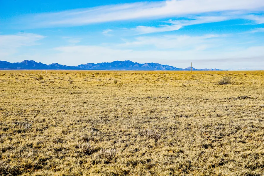
The literal English translation of the Spanish word estancia is stay. That couldnt be more appropriate, because thats exactly what youll want to do when you get to your acres of bliss in the desert terrain. Estancia is a quiet desert community in the heart of New Mexico. This property in Torrance County is located just west of HWY 41 and North of the town of McIntosh in the El Rancho Grande subdivision.
You have options when it comes to what to build or not on your lot. Since its a residential neighborhood, site built, manufactured or mobile homes are all allowed. You can camp with restrictions and RVs are allowed for up to 3 months with a permit from the planning and zoning department. Whatever you decide, youll wake up to breathtaking views every morning and end the days with gorgeous sunsets each night.
Property can be accessed via a dirt road on the Northern portion of the lot, not far from the iconic Route 66. Like they say, get your kicks on route 66. Then head right over to your new home in Estancia in Torrance County. Hurry, this area is highly sought after and this perfect one acre lot wont last long!
SUBDIVISION: ESTANCIA RANCHETTES
STREET ADDRESS: N/A, near Moriarty, NM 87035
STATE: NM
COUNTY: Torrance County, NM
ZIP: 87035
SIZE: 2.0 acres
LOT DIMENSIONS: 286 feet x 227 feet
APN: 1057053021121000000
LEGAL DESCRIPTION: Lots 17 and 18, Block 8, Unit 12 of Section 9, Township 09 North, Range 10 E, Torrance County, New Mexico.
LAT/LONG COORDINATES:
NW: 35.015708, -105.890998
NE: 35.015702, -105.890048
SW: 35.015089, -105.891004
SE: 35.015085, -105.890047
ELEVATION: 6,323 ft
ANNUAL TAXES: Approx. $90 per year
ZONING:
HOA/POA:
IMPROVEMENTS: None
ACCESS: There is a dirt road on the Western and Southern portion of the lot.
WATER: Would be a well, water haul and holding tank or other similar option
SEWER: Would be by Septic
UTILITIES: The nearest power post is about 800 feet from the lot. Power could also be by solar, wind or generator, Phone by cellular, satellite TV/Internet/Phone
From elevation to risk assessment
Search for detailed parcel information including; Elevation & Vegetation Maps, Ownership Information, Detailed Parcel Information, Crop History Map, Soil Survey Productivity Data, and more.
Research Parcel InformationDirections
ACCESS: There is a dirt road on the Western and Southern portion of the lot.
Resources
Land for Sale by Landopia
Torrance County Properties By Type
- Undeveloped Land for Sale in Torrance County, New Mexico
- Ranches for Sale in Torrance County, New Mexico
- Farms for Sale in Torrance County, New Mexico
- Residential Property for Sale in Torrance County, New Mexico
- Commercial Property for Sale in Torrance County, New Mexico
- Horse Property for Sale in Torrance County, New Mexico
- Recreational Property for Sale in Torrance County, New Mexico
- Lakefront Property for Sale in Torrance County, New Mexico
- Hunting Land for Sale in Torrance County, New Mexico
- Timberland for Sale in Torrance County, New Mexico
- Beachfront Property for Sale in Torrance County, New Mexico
- Riverfront Property for Sale in Torrance County, New Mexico
Properties for Sale Nearby Counties
Torrance County Properties By City
- Cedarvale, New Mexico Land for Sale
- Clines Corners, New Mexico Land for Sale
- Encino, New Mexico Land for Sale
- Estancia, New Mexico Land for Sale
- Mcintosh, New Mexico Land for Sale
- Moriarty, New Mexico Land for Sale
- Mountainair, New Mexico Land for Sale
- Torreon, New Mexico Land for Sale
- Willard, New Mexico Land for Sale
- Lucy, New Mexico Land for Sale
- Progresso, New Mexico Land for Sale
- Tajique, New Mexico Land for Sale
- More
- Abo, New Mexico Land for Sale
- Alexander Place, New Mexico Land for Sale
- Anderson Place, New Mexico Land for Sale
- Antelope Springs, New Mexico Land for Sale
- Benson Place, New Mexico Land for Sale
- Bermadez Place, New Mexico Land for Sale
- Brizendine Place, New Mexico Land for Sale
- Broncho, New Mexico Land for Sale
- Brown Place, New Mexico Land for Sale
- C Davis Place, New Mexico Land for Sale
- Candelaria Place, New Mexico Land for Sale
- Carnero, New Mexico Land for Sale
- Chato, New Mexico Land for Sale
- Chaves Place, New Mexico Land for Sale
- Chupadera, New Mexico Land for Sale
- Culebra, New Mexico Land for Sale
- D Candelaria Ranch, New Mexico Land for Sale
- Danvik Place, New Mexico Land for Sale
- Derramadero, New Mexico Land for Sale
- Dummoor, New Mexico Land for Sale
- Dunn Place, New Mexico Land for Sale
- E Davis Place, New Mexico Land for Sale
- El Gato, New Mexico Land for Sale
- Glover Place, New Mexico Land for Sale
- Gran Quivira, New Mexico Land for Sale
- Hewitt Place, New Mexico Land for Sale
- Hyde Place, New Mexico Land for Sale
- Jarett Place, New Mexico Land for Sale
- Johns Place, New Mexico Land for Sale
- King Place, New Mexico Land for Sale
- La Cienega, New Mexico Land for Sale
- Maez Place, New Mexico Land for Sale
- Manzano, New Mexico Land for Sale
- Martin Place, New Mexico Land for Sale
- Martinez, New Mexico Land for Sale
- McKinley Place, New Mexico Land for Sale
- Moorehead Place, New Mexico Land for Sale
- Negra, New Mexico Land for Sale
- Nelson Place, New Mexico Land for Sale
- North Lucy, New Mexico Land for Sale
- Palma, New Mexico Land for Sale
- Pedernal, New Mexico Land for Sale
- Pine Springs, New Mexico Land for Sale
- Punta de Agua, New Mexico Land for Sale
- Riley Place, New Mexico Land for Sale
- Romero Place, New Mexico Land for Sale
- Saiz Place, New Mexico Land for Sale
- Scholle, New Mexico Land for Sale
- Silio, New Mexico Land for Sale
- Stockton Place, New Mexico Land for Sale
- Thompson Place, New Mexico Land for Sale
- Thunderbird, New Mexico Land for Sale
- Torrance, New Mexico Land for Sale
- Varney, New Mexico Land for Sale
- Witt, New Mexico Land for Sale
