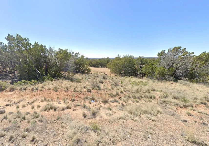
1.25 Acres in Saint Johns, Arizona
Owner Financing Available - This 1.25 acre lot is located in Saint Johns, Arizona and the address is N7218, Saint Johns, AZ 85936.
Saint Johns is the county seat of Apache County, Arizona, United States. It is located along U.S. Route 180, mostly west of where that highway intersects with U.S. Route 191. As of the 2010 census, the population of the city was 3,480.
Features: Close to Highway 191
Only $500 Down and $150/month for 37 months = $6050 or Discounted Cash Price: $4997
PROPERTY DETAILS
APN: 205-11-333
Address: N7218, Saint Johns, AZ 85936
County: Apache
State: Arizona
Size: 1.25 Acres
Dimensions: 167' x 326'
Legal: Subdivision: Witch Well Ranches Unit 4 Lot: 333
Terrain: Flat
Access: Dirt Road
Power: Power in the Area (Power Company: Navopache Electric Co-Op: 928-337-4414 )
Water: Water in the Area (Arizona Water Co: 928-535-4469 ) (Well: SUNBELT DRILLING: 602-376-1123) (Water Haul: White Mountain Water Hauling: 928-240-1165)
Sewer: Sewer or Septic in the Area (Septic: B C Septic: 928-337-2764)
Taxes per Year: $6
HOA Fees per Year: No HOA/POA
GPS Coordinates (center) at the road: 34.901982, -109.268103
--- Northwest Corner: 34.902231, -109.268654
--- Northeast Corner: 34.902226, -109.267557
--- Southwest Corner: 34.901777, -109.268659
--- Southeast Corner: 34.901770, -109.267559
Elevation: 6177
BUILDING INFORMATION
Zoning: AZ-Navajo-A-General
Time Limit to Build: No time limit to build
Site Built Homes Allowed: Allowed. 174 min sqft
Modular Homes Allowed: Allowed. 174 min sqft
Manufactured Homes Allowed: Allowed
Mobile Homes Allowed: Allowed
Tiny Homes Friendly: Allowed. 174 min sqft
ALLOWABLE USES
Full-Time RV Living Allowed: Not Allowed
RV on the Property While I build: Not Allowed
Camping in a RV Allowed: Not Allowed
From elevation to risk assessment
Search for detailed parcel information including; Elevation & Vegetation Maps, Ownership Information, Detailed Parcel Information, Crop History Map, Soil Survey Productivity Data, and more.
Research Parcel InformationDirections
From Sanders Unified District
Arizona, USA
1.Head northeast on I-40 E
2.Take exit 339 for US-191 S toward St Johns
3.Turn right onto US-191 S
4.Turn right onto N7200
5.Turn right onto N7218
6.Lot is on the right
Resources
Land for Sale by Benjamin Davis
Apache County Properties By Type
- Undeveloped Land for Sale in Apache County, Arizona
- Ranches for Sale in Apache County, Arizona
- Farms for Sale in Apache County, Arizona
- Residential Property for Sale in Apache County, Arizona
- Horse Property for Sale in Apache County, Arizona
- Recreational Property for Sale in Apache County, Arizona
- Hunting Land for Sale in Apache County, Arizona
- Lakefront Property for Sale in Apache County, Arizona
- Timberland for Sale in Apache County, Arizona
- Riverfront Property for Sale in Apache County, Arizona
- Beachfront Property for Sale in Apache County, Arizona
- Commercial Property for Sale in Apache County, Arizona
Properties for Sale Nearby Counties
- Catron County, Arizona Land for Sale
- Cibola County, Arizona Land for Sale
- Graham County, Arizona Land for Sale
- Greenlee County, Arizona Land for Sale
- McKinley County, Arizona Land for Sale
- Montezuma County, Arizona Land for Sale
- Navajo County, Arizona Land for Sale
- San Juan County, Arizona Land for Sale
- San Juan County, Arizona Land for Sale
Apache County Properties By City
- Alpine, Arizona Land for Sale
- Chambers, Arizona Land for Sale
- Chinle, Arizona Land for Sale
- Concho, Arizona Land for Sale
- Dennehotso, Arizona Land for Sale
- Eagar, Arizona Land for Sale
- Fort Defiance, Arizona Land for Sale
- Ganado, Arizona Land for Sale
- Greer, Arizona Land for Sale
- Houck, Arizona Land for Sale
- Lukachukai, Arizona Land for Sale
- Lupton, Arizona Land for Sale
- More
- Many Farms, Arizona Land for Sale
- Mcnary, Arizona Land for Sale
- Nazlini, Arizona Land for Sale
- Nutrioso, Arizona Land for Sale
- Rock Point, Arizona Land for Sale
- Round Rock, Arizona Land for Sale
- Saint Johns, Arizona Land for Sale
- Saint Michaels, Arizona Land for Sale
- Sanders, Arizona Land for Sale
- Springerville, Arizona Land for Sale
- Teec Nos Pos, Arizona Land for Sale
- Vernon, Arizona Land for Sale
- Window Rock, Arizona Land for Sale
- Concho Valley, Arizona Land for Sale
- Cornfields, Arizona Land for Sale
- Greasewood, Arizona Land for Sale
- Klagetoh, Arizona Land for Sale
- Mexican Water, Arizona Land for Sale
- Red Mesa, Arizona Land for Sale
- Richville, Arizona Land for Sale
- Rough Rock, Arizona Land for Sale
- Salado, Arizona Land for Sale
- Salina, Arizona Land for Sale
- Steamboat Canyon, Arizona Land for Sale
- Sunrise Springs, Arizona Land for Sale
- Tahchee, Arizona Land for Sale
- Toyei, Arizona Land for Sale
- Adamana, Arizona Land for Sale
- Allentown, Arizona Land for Sale
- Boneyard, Arizona Land for Sale
- Bonita Trading Post, Arizona Land for Sale
- Burnside, Arizona Land for Sale
- Chetco, Arizona Land for Sale
- Correjo Crossing, Arizona Land for Sale
- Cove, Arizona Land for Sale
- Coyote Springs, Arizona Land for Sale
- Crosby Crossing, Arizona Land for Sale
- Del Muerto, Arizona Land for Sale
- Diamond Fields, Arizona Land for Sale
- El Tule, Arizona Land for Sale
- Emmanuel Mission, Arizona Land for Sale
- Feaster, Arizona Land for Sale
- Flat Rock, Arizona Land for Sale
- Green Spot, Arizona Land for Sale
- Greer Place, Arizona Land for Sale
- Hawley Lake, Arizona Land for Sale
- Heap Place, Arizona Land for Sale
- Hunt, Arizona Land for Sale
- Hunters Point, Arizona Land for Sale
- Junction Overlook, Arizona Land for Sale
- Kinlichee, Arizona Land for Sale
- Kinney Junction, Arizona Land for Sale
- Los Burros, Arizona Land for Sale
- Lower Wheatfields, Arizona Land for Sale
- Maverick, Arizona Land for Sale
- Mexican Water Trading Post, Arizona Land for Sale
- Milkwater, Arizona Land for Sale
- Navajo, Arizona Land for Sale
- Northwoods, Arizona Land for Sale
- Oak Springs, Arizona Land for Sale
- Paulcell Place, Arizona Land for Sale
- Pine Springs, Arizona Land for Sale
- Pinta, Arizona Land for Sale
- Potter Place, Arizona Land for Sale
- Rosebud, Arizona Land for Sale
- Sand Springs, Arizona Land for Sale
- Sehili, Arizona Land for Sale
- Steamboat, Arizona Land for Sale
- Tanner Springs, Arizona Land for Sale
- Tes Nez Iah, Arizona Land for Sale
- Three Forks, Arizona Land for Sale
- Totacon, Arizona Land for Sale
- Troweek, Arizona Land for Sale
- Tsintaa Yiti Ii, Arizona Land for Sale
- Twin Falls, Arizona Land for Sale
- Upper Wheatfields, Arizona Land for Sale
- Wheatfields, Arizona Land for Sale
- White Clay, Arizona Land for Sale
- Wide Ruins, Arizona Land for Sale
- Wood Springs, Arizona Land for Sale
- Woodspring Trading Post, Arizona Land for Sale
- Yazzi, Arizona Land for Sale